Top Tweets for #bcwind

#BCStorm #BCwx #BCStormWatch #BCWind
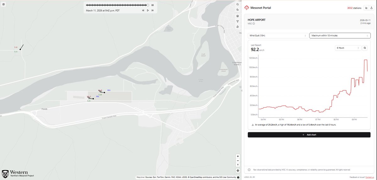
In Hope, gusts as high as 116 & 139 kmh have been recorded at the ECCC & NavCanada WX Stations, respectively.
Willing to bet the latter reading is at least slightly erroneous (overdone), but nonetheless, the winds are, as usual, exceeding expectations in Hope!

#BCStorm #BCwx #BCStormWatch
https://t.co/pTmmPKxg4T
https://t.co/ooLH9XILHN
https://t.co/IUF2mEsqND
https://t.co/lDRaAKQprK
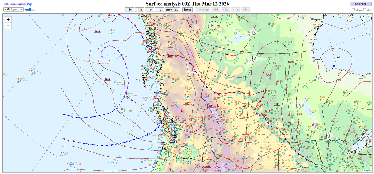
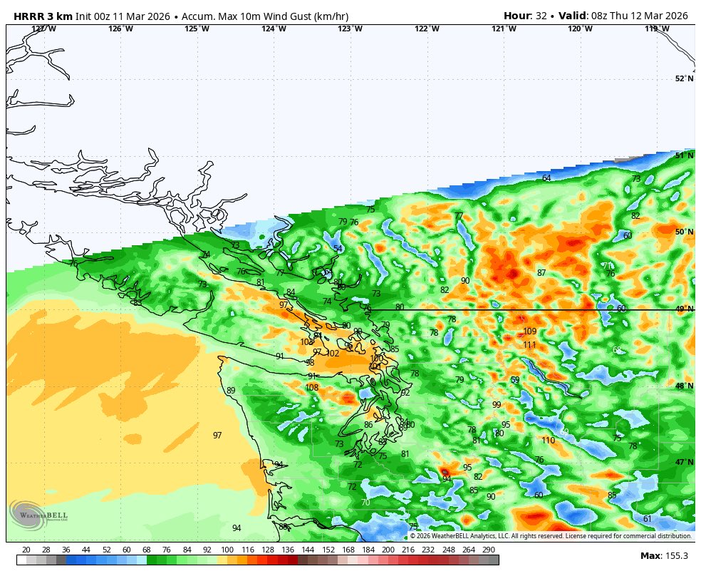
So far, thanks to the low & related frontal system/CF, 30-55 mph/~50-90 kmh gusts have been seen since this afternoon in many parts of the coast, with Hope very recently reporting wind gusts of up to around 110 kmh/70 mph(!). Meanwhile, most of the Interior continues to sit & wait, while some others have experienced or continue to experience gusts up to 25-45 mph/~40-75 kmh. (As anticipated)
Patchy-widespread precip has also been impacting most of Southern BC as well since this afternoon.
(Forecast has been provided in the links above, w/ any necessary changes noted in the reply section of the forecast posts 🙂)


Meteorological Service of Canada observation station at #YHE showing a wind gusts to 116km/h at 9:40p PDT — the NAVCanada site showing a gust to 139km/h (which seems sus)
Anyone in #HopeBC?? @PopShopRadio1??
#BCstorm #BCwind #BCstormwatch #YHEwx @ThierryGooseBC @50ShadesofVan

#BCStorm #BCwx #BCStormWatch #BCWind
As the wind event, thanks to our low w/ associated CF/frontal system & strong winds aloft, continues/begins to get underway, here is a complete look at the current alerts...
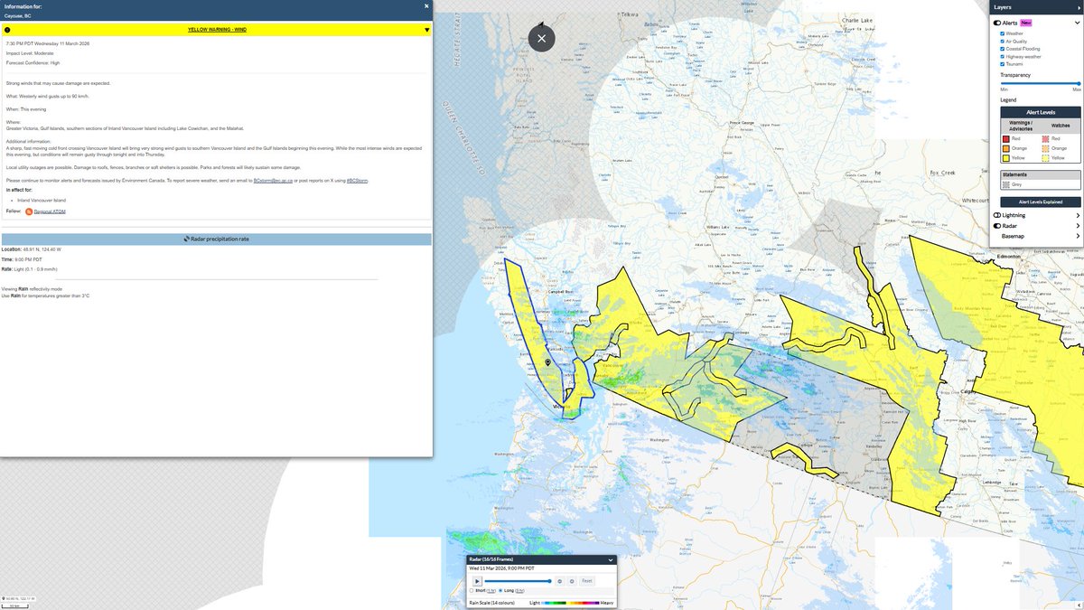
- Wind Warning for the Greater Victoria, Gulf Islands, southern sections of Inland Vancouver Island including Lake Cowichan, and the Malahat for the potential for up to 90 km/h gusts this evening, w/ lingering elevated winds possible for the rest of tonight into Thursday.
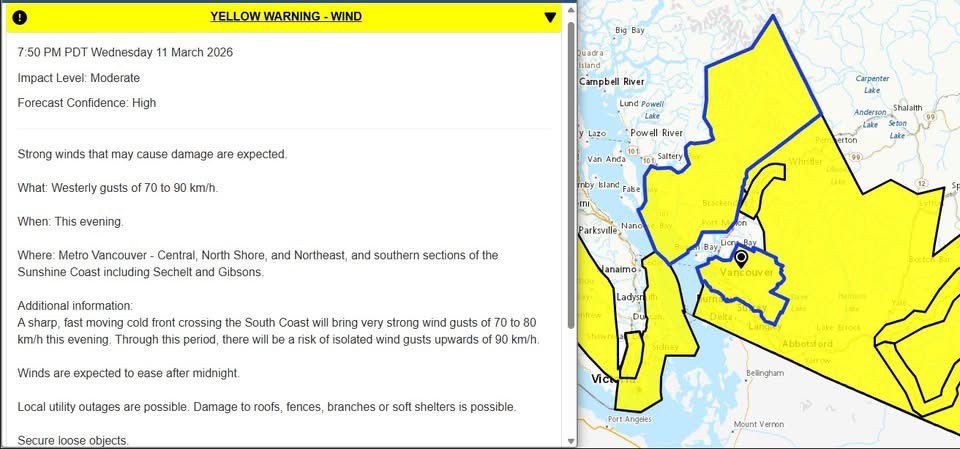
- Wind Warning for Metro Vancouver - Central, North Shore, and Northeast, and southern sections of the Sunshine Coast including Sechelt and Gibsons for the potential for up to 70-90 km/h gusts this evening.
- Wind Warning for the Fraser Valley & Metro Vancouver - Southwest and Southeast for the potential for up to 90 km/h gusts (up to 90-100 km/h for the East FV) this evening, w/ lingering elevated winds possible for the rest of tonight into Thursday.
- Snowfall Warning for the Sea to Sky Highway north of Squamish, and Whistler for the potential for up to 15-25 cm of snow.
- Wind Warning for the Fraser Canyon - south including Lytton, Manning - Skagit Valley, Similkameen, Nicola, Central and South Okanagan - including Kelowna and Penticton, & Coq - Kamloops to Merritt for the potential for up to 90 km/h gusts tonight.
- Winter Storm Warning for the Coquihalla Highway - Hope to Merritt for the potential of up to 50 cm of snow by Thursday morning, w/ wind gusts up to 100 km/h & blowing snow-blizzard conditions possible tonight, changing to the possibility of blowing snow & gusty winds Thursday morning. (Rapidly-changing conditions are expected, see alert below for further details)
- Winter Storm Warning for Highway 3 - Hope to Princeton & Okanagan Connector - Merritt to Kelowna for up to 15 cm of snow possible by Thursday morning, w/ wind gusts up to 100 km/h & blowing snow-blizzard conditions possible tonight, changing to the possibility of blowing snow & gusty winds Thursday morning. (See alert below for further details)
- Special Weather Statement for the North Okanagan - including Vernon and the Kootenays for the potential for up to 80 km/h late this evening to Thursday morning.
- Snowfall Warning for the West Columbia, Golden/East Columbia, and Yoho Park - Kootenay Park for up to 10-15 cm of snow possible by tmrw morning, w/ blowing snow possible.
- Snowfall Warning for the Trans-Canada Highway - Eagle Pass to Rogers Pass for up to 25 cm of snow possible for tmrw morning, w/ blowing snow possible.
- Snowfall Warning for the Elk Valley for up to 25-35 cm of snow possible by Thursday morning, w/ blowing snow-blizzard like conditions possible.
- Winter Storm Warning for Highway 3 - Paulson Summit to Kootenay Pass for up to 35 cm of snow possible by Thursday morning, w/ wind gusts up to 80 km/h & blowing snow-blizzard like conditions possible tonight, changing to the possibility of blowing snow & gusty winds Thursday morning. (See alert below for further details)

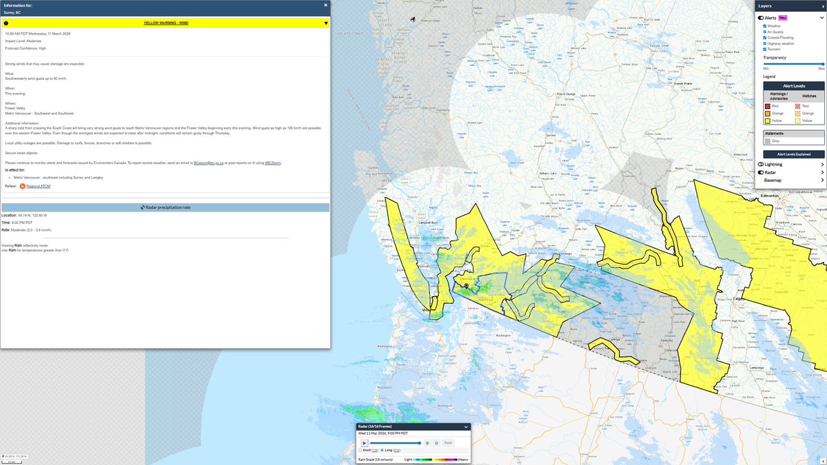

Yellow Warnings for Wind Expanded to cover All of Metro Vancouver!!
Strong westerly winds 70 gusting to 90km/h that may cause damage are expected this evening. Winds, tho delayed, should ramp up in the next hour or two!
#BCstorm #BCstormwatch #BCwx #BCwind

Strong wind storm likely Tomorrow PM.
100km (60mph+) likely over puget sound and Eastern Vancouver Island. 60-90km/hr (35-55mph) other areas.
#bcstorm #wawx #windstorm #storm #bcwind

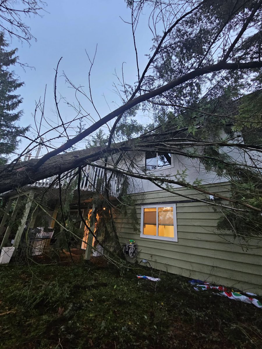
While BC Hydro crews continue their cleanup, local homeowners in the BC Lower Mainland, inclg my friends, await their insurance adjuster as a large tree fell on their house overnight. Thankful they were unharmed.
H/T 📸: Anita & Kristina
#BCStorm #BCwind #BCwx #PortCoquitlam


#BCStorm #BCwx #BCStormWatch #BCWind
WIND STORM UPDATE
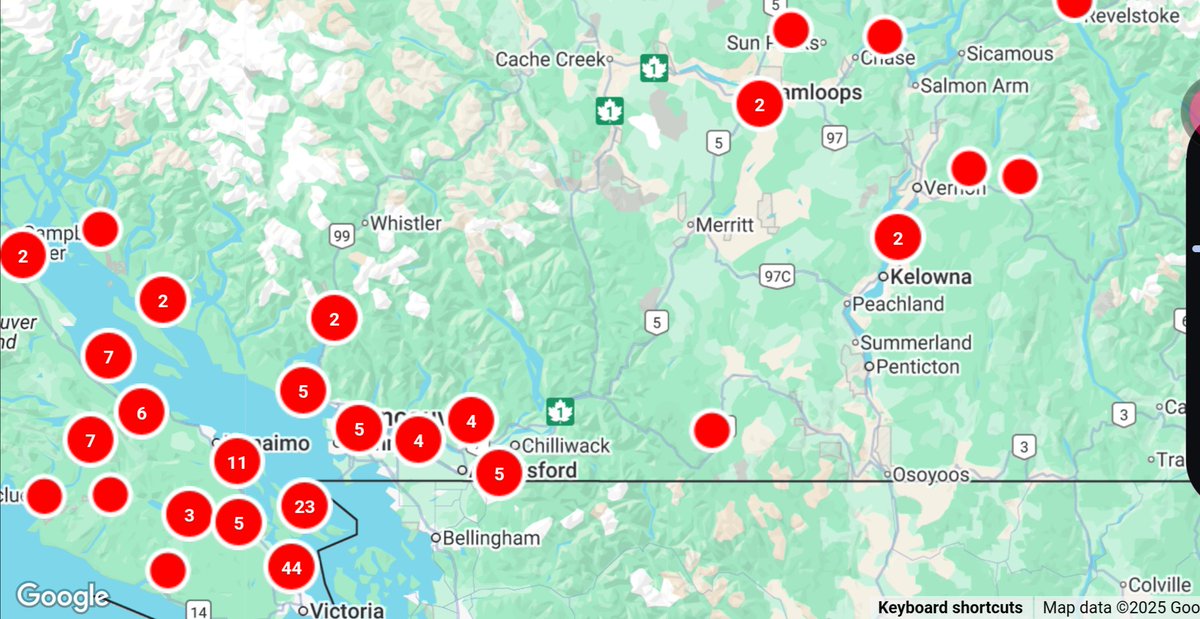
Progress is being made, but tens of thousands remain without power on the coast after last night's-this morning's wind storm!


That pails in comparison to the southern BC coast, where just under 100 thousand remain in the dark after strong winds (up to 50-90 km/h, a few isolated areas at or above 100 km/h) slammed the region earlier today, causing extensive wind damage!
#BCStorm #BCwx #BCStormWatch


#BCStorm #BCwx #BCWind
**EARLY MORNING UPDATE**
*Late eve/Early overnight to early-mid this morning, 50-90 km/h gusts are ongoing, but are expected to continue to gradually wane, in the southern coastal regions, w/ higher gusts (up to 100+ km/h) remaining possible in higher elevations.
However, up to 100-110 km/h gusts ended up occurring in the far South Island & East FV!
Meanwhile, the winds are performing just as expected down on the coast, strong (gusts between 50-90 km/h) & damaging, with over a hundred thousand without power across the Lower Mainland & South Island!
#BCStorm #BCwx #BCStormWatch #BCWind


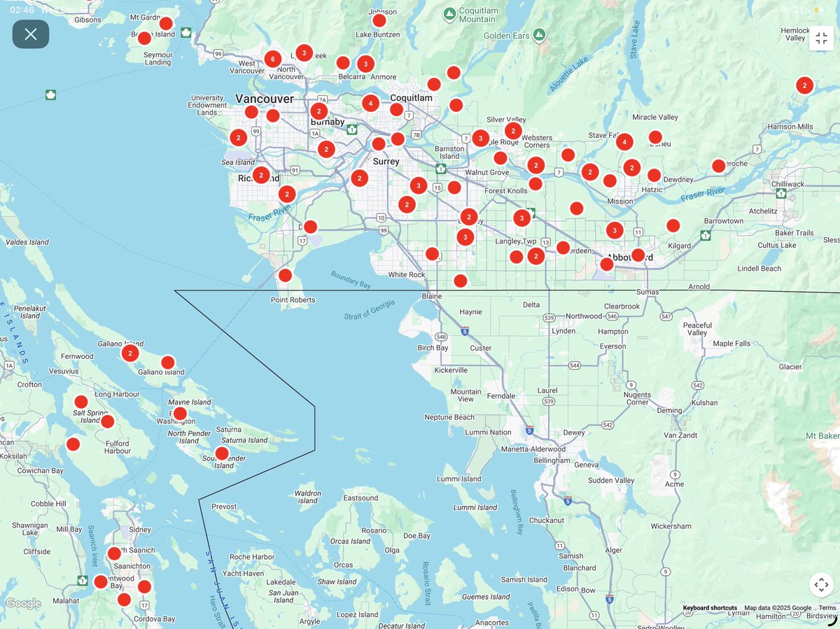
Fallen Hemlock tree taking down @bchydro power lines in downtown Vancouver w/ police on scene— over 140 outages w/ 105,500+ customers affected in just the Lower Mainland, & Sunshine Coast alone.
Remember to stay 10m+ away from downed lines. 420a
#BCStorm #BCStormWatch #BCWind
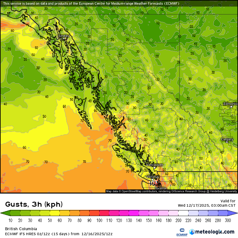
A look on radar at that secondary front barreling through the BC Lower Mainland with another bout of very gusty winds and wind driven rain. Temps continue to drop as denser, colder air moves in.
CASAG - Super-Res Reflectivity 1 03:59 #BCStorm #BCstormwatch #BCwx #BCwind
A second front coming through the Lower Mainland with another round of winds gusting to 80km/h and heavy rain.
Temps now down to 4°C and occasionally “chunky rain” in downtown Vancouver — 3:55a PT
#BCSTORM #BCSTORMWATCH #BCWX #BCWIND #YVRWX
At 1am we were around 20k @bchydro customers without power… At 2:41am we are at just under 83000 customers without power on the Lower Mainland and S Vancouver Island.
Winds are easing but this will take time for crews to fix!
#BCstorm #BCstormwatch #BCwind #BCwx #PowerOutage
Winds howling at English Bay beach 1:30a — the temperature dropping 4°C (now 7°C) with the passage of the cold front. Feels so cold after our 16°C just yesterday!
#BCStorm #BCStormWatch #BCWind #BCWX
Just under 20000 @BChydro customers without power at 1am | 17 December 2025 | Let’s see how that looks in an hour or two!
#BCstorm #BCstormwatch #BCwind #BCwx

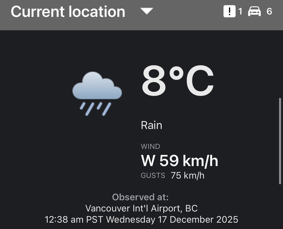
Wind shift, now gusting to 75 km/h at YVR!
Winds were ESE at 10 km/h at YVR at 12AM, now W gusting to 75km/h at 12:38AM — the vigorous cold front now making its way across the Lower Mainland
#BCStorm #BCStormWatch #BCWX #BCWind 
Front incoming… Heavy rain and gusty winds to start affecting western sections of Metro Vancouver before 1am | 17 December 2025
#BCstorm #BCstormwatch #BCwind #BCwx
#BCStorm #BCwx #BCWind
Not like its needed, but once again, these winds, on top of some help from the overly saturated soils due to the recent rainfall, are anticipated to cause extensive tree damage & related power outages.
As for elsewhere, 30-60 km/h gusts will be possible, w/ higher gusts (up to 70-90 km/h) possible in higher elevations.
However, winds for southern coastal regions will gradually wane during the morning.
Eventually, by late morning tmrw, & continuing through the rest of the day tmrw, generic 30-60 km/h gusts will be expected for some-most of the coast.


Last Seen Hashtags on Sotwe
Trends for you
Most Popular Users

Elon Musk 
@elonmusk
240.2M followers

Barack Obama
@barackobama
119.3M followers

Donald J. Trump
@realdonaldtrump
111.6M followers

Cristiano Ronaldo
@cristiano
109.4M followers

Narendra Modi
@narendramodi
106.9M followers

Rihanna
@rihanna
97.4M followers

NASA
@nasa
92.1M followers

Justin Bieber
@justinbieber
90.7M followers

KATY PERRY
@katyperry
87M followers

Taylor Swift
@taylorswift13
80.9M followers

Lady Gaga
@ladygaga
72.4M followers

Kim Kardashian
@kimkardashian
69.5M followers

Virat Kohli
@imvkohli
68.9M followers

YouTube
@youtube
68.6M followers

Bill Gates
@billgates
63.5M followers

The Ellen Show
@theellenshow
62.5M followers

CNN
@cnn
61.9M followers

Neymar Jr
@neymarjr
61.5M followers

X
@x
60.9M followers

Selena Gomez
@selenagomez
60.1M followers