I developed a tutorial on Google Colab for using #Python (esp. @xarray_dev) for geospatial / climate data analysis🧵 1️⃣/5
🔗 Link to the code: https://t.co/fjLT3WmAJn
🔗 An article I wrote explaining the details:
https://t.co/eW8u6JSsBT
📢 I’ve started a new newsletter–GeoAI Unpacked–to share deep dives and insightful analyses on AI & geospatial / climate-tech industry.
🛰️ For the 1st issue, I've explored EO foundation models. Check it out and subscribe to stay tuned:
https://t.co/xQOMPmmFgc
@KellyHereid @geosmx Thanks for the shout out :) Much appreciated! Lots of opportunities now available at the intersection of climate, insurance, and AI.
@Keiko_geo The article implies financial reasons for the layoff. Yet they had hired scientists even two months ago (who are now laid off). Maybe they were in the midst of fundraising and things didn’t go as planned? Still, not cool to join and let go a few weeks afterwards 😐
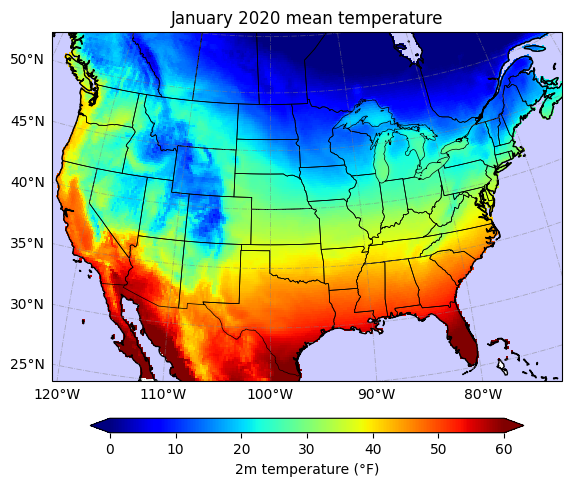
I've also shared the code to generate high quality plots using Cartopy:
+ Visualize in a desired geographic projection
+ Add features like state boundaries
+ Customize the colorbar
📎 Link to notebook on Github: https://t.co/w9PBhTD1Dv
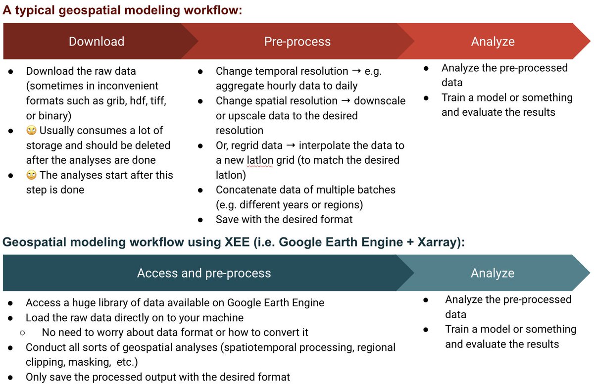
I’ve developed a new #python tutorial that combines the power of Google Earth Engine and @xarray_dev for geospatial data analysis. The combo seems really powerful and convenient to use!
🔗 Here's an article I wrote to explain the details:
https://t.co/sM51K2BmJT
@hagertynw@pazjusticiavida@Tuholske @paul_d_bates Here's the free access link to that paper: https://t.co/9bg4j7fTyj
(from this tweet https://t.co/hydVAlS5e5)
@aravindEO@mouthofmorrison Sorry to hear about the layoffs. Happy to help (and possibly refer) those who are impacted. Planet has hired a lot of top notch talents over the past years.
3 weeks of California storms visualized in 30sec. ~30 trillion gallons of water! I shared a few points about the event here: https://t.co/BCiVhqJgg4
Data: MRMS (by NOAA) on AWS S3 (hourly, 1km spatial resolution)
Tools: Python (mainly xarray & cartopy)
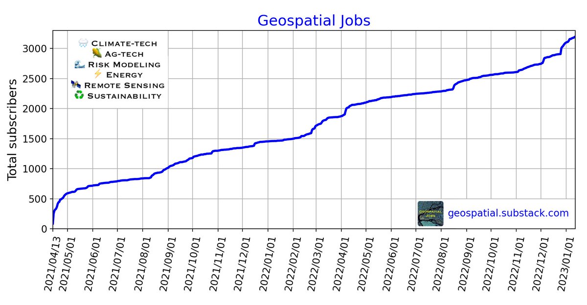
I've been sharing a newsletter focused on technical & data science jobs in geospatial (i.e. 🌧climate-tech, 🌽ag-tech, 🌊risk modeling, ⚡️energy, 🛰remote sensing, & ♻️sustainability).
If that sounds interesting, check it out & I hope you find it helpful: https://t.co/XOH9I1MaPX
Here's my conversation with Abbas Amanat, a historian at Yale specializing in the modern history of Iran. We talk about the Iran protests, the death of Mahsa Amini, abuses of power, nuclear weapons, and the history & future of Iran and the Middle East. https://t.co/lder9TW90t
@melliott_water It's a shame that many of our Iranian-American faculty (& students) have been silent & ignorant in the public & on social media (not even liking any posts about #IranProtests2020). Thank you Mark for being our voice! ❤️👏👏
Career update: This Monday was my first day at Google[X] @Theteamatx. I'm super excited to work on ML & geospatial applications for environmental extreme events. Climate change has been an integral part of my career & I'm glad to now work on it in a highly technical environment🚀
I was interviewed by @BusinessInsider to elaborate on my experience in the climate-tech industry. Here's a summary of my conversation: https://t.co/MLVEIzp9Xc
Worth mention: Get comfortable w/ rejections. If you’re not being rejected, you’re not pushing beyond your comfort zone.
@benatoms This article explains some issues of CAT models: https://t.co/jxu1KrAi4O
Several startups are working w/ insurance & financial institutes, partly due to the shortcomings of CAT models (though GCMs are problematic too). Thus I'd say there should be a market for "better" data.
@benatoms I think RMS has some info about CAT modeling: https://t.co/jYmNfF3TPj
I suggest you to take a look at these too:
1. Cat models and climate risk models: friends or foes? https://t.co/mwt2W0xJMs
2. Why climate models struggle with acute physical risks: https://t.co/lVpWAy5pOi