من كانتِ الآخرةُ هَمَّهُ
1- جعلَ اللَّهُ غناهُ في قلبِهِ
2- وجمعَ لَه شملَهُ
3- وأتتهُ الدُّنيا وَهيَ راغمةٌ
ومن كانتِ الدُّنيا همَّهُ
1- جعلَ اللَّهُ فقرَهُ بينَ عينيهِ
2- وفرَّقَ عليهِ شملَهُ
3- ولم يأتِهِ منَ الدُّنيا إلَّا ما قُدِّرَ لَهُ
صدق رسول الله صلى الله عليه وسلم
🌧️أواخر نوفمبر وبدايات ديسمبر- توقّعات الحالة المطرية شرق المتوسّط
حالة مطرية ثانية في اواخر الشهر الجاري محتملة بعد الحالة المتوقعة نهاية الاسبوع الجاري .
تشير خوارزميات التحليل المركّب وخرائط الانحرافات المطرية (1991–2020) إلى عودة نشاط مطري واضح على منطقة شرق البحر المتوسّط خلال الثلث الأخير من شهر نوفمبر، مع احتمال امتداد الفعالية إلى الأيام الأولى من ديسمبر.
🌦️ أهم الإشارات من الخرائط:
🔹 المناطق ذات التلوّن الأزرق والبنفسجي مرشّحة لتلقّي كميات أمطار أعلى من المعدل الموسمي.
🔹 اللون البنفسجي الداكن يشير لاحتمالية هطولات غزيرة قد تصل لحدّ السيول والفيضانات.
🟪 المناطق داخل المربّعات البنفسجية (المُظلّلة على الخرائط):
تشير الإشارات التحليلية إلى أنّ المناطق المحاطة بالمربعات والتي تُظهر انحرافات مطرية بنفَس بنفجسي قوي قد تكون ضمن نطاق:
سوريا (الغربية والجنوبية)
لبنان
فلسطين
شمال ووسط الأردن
أجزاء من جنوب تركيا
العراق
قبرص
اجزاء من الاناضول و البلقان .
وتُظهر هذه المناطق أعلى معامل خطورة نتيجة:
✔️ غزارة الهطول خلال فترات قصيرة
✔️ احتمالية الجريان السطحي القوي (Runoff)
✔️ زيادة فرص السيول المفاجئة
✔️ وفي بعض السيناريوهات: خطر الفيضانات المحلية
⚠️ المخاطر المحتملة ما بين 22–30 نوفمبر (وقد تمتد لبدايات ديسمبر):
سيول محلية في الأودية والمناطق المنخفضة.
جريان سطحي سريع نتيجة تشبّع التربة.
احتمال فيضانات حضرية في المدن ذات البنية التصريفية الضعيفة.
اضطرابات مرورية وانخفاض الرؤية.
📌 خلاصة:
الثلث الأخير من نوفمبر يبدو نشطاً مطرياً بشكل لافت شرق المتوسّط، مع بروز نطاقات بنفجسية تُنذر بأمطار غزيرة وسيول واحتمال فيضانات. حاليا النماذج الرقمية لا تظهر سوى اشارات على هذه الحالة و التحليل الحالي هو استباق لها . وتمتد هذه المؤشرات إلى الأيام الأولى من ديسمبر وفق آخر الخرائط التحليلية و هي احتمالية ليست حتمية بالظرف الحالي .
الانتباه للمناطق الموشحة بلون وردي لمخاطر السيول.
مزيد من الصور في التعليق الاول .
والله أعلم
تم من قبل قسم الاحصاء التطبيقي موقع الهدهد , اربد الاردن
✍️ @Statisticizer
#مبدئي
العامل المميز في منخفضات الشتاء القادم سيكون كثرة الغيوم المنخفضة Low clouds system بدءا من يناير خصوصا في المناطق شبه المدارية. هذه الغيوم (ارتفاع ٣.٢ كم) يرافقها قي العادة تشكلات خلايا السوبر سيل و امطار فيضية و بروق شديدة تشبه الألعاب النارية .
تم حساب ارجحياتها بمحاكاة عوامل الغيوم و الأشعة الكونية cosmic rays influx و اظهر زيادة ف ينسبت حدوثها عن المعتاد.
قريبا انشر خرائط الشتاء بتحليل مؤشرات كيب للخلايا العملاقة سَوبرسيل supercell CAPE index
و غالبا تكون ملحوظة في شهر يناير تزيد بشهري فيبراير و مارس . و الله اعلم.
#SSW Polar Vortex Sudden Stratospheric Warming SSW Watch – December 2025 Outlook.
Based on a set of 33 autumn analogs for 2025, the following assessment provides a probabilistic, not deterministic, interim view of stratosphere–troposphere dynamics heading into early winter. Signals at 10 hPa show a marked wave-1 disturbance with strong polar-cap warming beginning in the first December dekad, intensifying sharply into the second dekad (10–21 Dec). The 10hpa Geopotential height anomalies climb over Siberia and Greenland while zonal winds weaken and flip easterly—hallmarks of a major possible polar vortex displacement-type SSW. By late December, the cold pool shifts toward Asia, confirming the vortex may will be pushed off the pole rather than a polar vortex split .
At 500 hPa, tropospheric coupling may begin to emerge: early December favors troughing across the North Atlantic and eastern North America, see comments section, followed by deeper negative heights over Canada and Greenland by mid-month, and a pronounced low-height center over Hudson Bay by late December.
This evolution suggests colder, stormier conditions may prevail for central and eastern North America, while Europe trends toward ridging and relative mildness, especially in the east and southeast.
In summary, the analogs point to a high probability of an early Polar Sudden Stratospheric Warming SSW onset around mid-December 2025, with downward influence most likely to manifest more fully in late December into January . This outlook remains interim and probabilistic, but the early-season disruption of the polar vortex is a key feature to watch closely.
🔴 Update on Europe & East Mediterranean Heat Patterns
As anticipated statistically, after the recent cool down over Central & Eastern Europe, a new Heat DOME is materializing over SE Europe (Balkans) as we move into early September.
📊 Today’s statistical analog outlook (Sept 1–12) shows strong positive anomalies over the Balkans, in agreement with NWP model trends. This suggests the development of a persistent heat dome, which may extend further south toward the northern Middle East / Levant countries if it intensifies. Milder conditions are expected for SW Europe and western parts of the continent .
🌡️ This pattern highlights a bounce back from late August’s cool phase into potentially #prolonged September heat across SE Europe and neighboring regions. Close monitoring is warranted for its duration and expansion. This heat may become #persistent for North Black Sea and South Urals even during second decade of September-well according to my statistical analogous modelling .
The statistical analogous outlook for 1-12 September is attached along other previous warnings!
⏳ A kind reminder to friends in the Balkans & Italy 🌍
Each statistical forecast I post takes significant time & effort. Without your shares, feedback & interaction, I may have to stop covering your region, just as I did earlier for the Levant & North Africa due to low engagement. Noting that I come from Jordan and I stopped covering my own country due to the same reasons and I DO NOT care stopping covering the region. Time is #GOLD do Not waste it .
Your interaction keeps these forecasts for your region alive. 💡
#Balkans #Italy #Forecast
#Europe #Balkans #HeatDome #Climate #Forecast
🔴#August_September
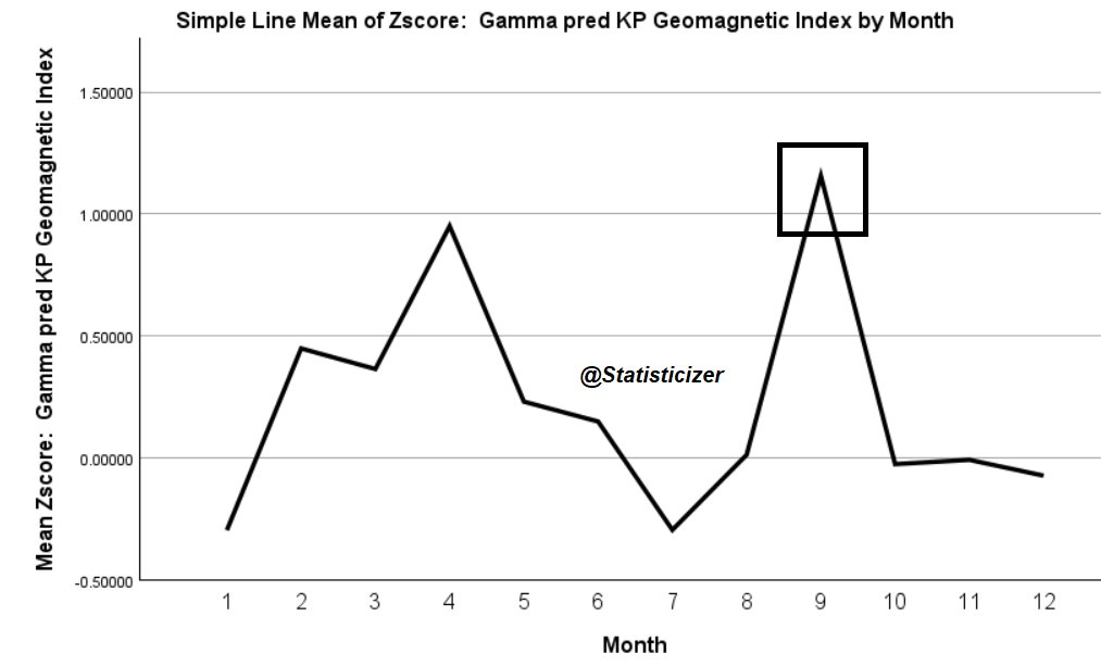
Planetary ephemerides analog analysis and gamma-regression-based #KPI predictions indicate a marked uptick in geomagnetic indices during September. Historically, similar upticks in KPI (and corresponding rises in solar flux and proton flux) have coincided with periods of heightened lithospheric activity.
In past analog years, such geomagnetic and solar activity surges often preceded or accompanied by:
⚠️*Increased silica-rich #volcanic #activity — particularly from subduction zone stratovolcanoes.
⚠️*Elevated #seismic #activity ( earthquakes ) , especially in tectonically active belts such as the Pacific Ring of Fire, Mediterranean–Middle East zone ( Turkey) , and other high-strain regions.
Historically- Delays between KPI rise or fall and such phenomena may occur in some instances .
This relationship is not deterministic but is supported by multiple observational correlations in historical datasets linking solar–geomagnetic variability with geophysical responses in the lithosphere. Close monitoring of both space weather parameters and geophysical alerts is advised through transition between August- September-October.
The #KPI index is a geomagnetic activity indicator derived from, or closely related to, the NOAA/NGDC Kp index. It represents planetary-scale geomagnetic disturbances caused mainly by variations in the solar wind and interplanetary magnetic field interacting with Earth’s magnetosphere.
نشرة اولية لفصل الخريف -الجزيرة العربية . السعودية و الخليج العربي .
باستخدام عوامل الاتصال المناخي و تاثير الجبال Mountain Torque-MT و تذبذب عوامل مادين جوليان ( الموجة الباردة) اضافة لمؤشرات تذبذب الصيف BSISO1.2 الحالية تم تحديد على الاقل 36 موسم خريفي مشابه ( او مقارب) للموسم الجاري بطرق و تطبيقات الذكاء الاصطناعي و الحساب المتقدم .
بناءا على المخرجات و هي اولية احتمالية من المرجح ان نشهد تزايد بفرص الهطول المطري على اجزاء كبيرة من الجزيرة العربية تشمل كل من ( #السعودية , غرب #اليمن , غرب #عمان , منطقة الخليج العربي #الامارات و عمان و #قطر اضافة لبعض مناطق وسط و شمال غرب السعودية ) باشهر الخريف بين سبتمبر و ديسمبر . تتزايد فرص الهطول المطري تدريجيا بمشيئة الله بدخول شهر سبتمبر و تقوى نسبيا باكتوبر و نوفمبر ثم تتراجع من ناحية الشمولية بديسمبر . شهر ديسمبر يوجد به تباين مكاني كبير بالهطولات بشكل عام لكن اضعف بالعموم من بقية اشهر الخريف .
بالورقة المرفقة المناطق الموضحة بلون اصفر و برتقالي مناطق تشهد فرص تشكل الغيوم و الهطول ألمطري المتوقع تشكلها على شكل convective rain ,و الله اعلم .
هذه النشرة مجموع لمجمل الامطار بشهور الخريف مجتمعةو هي احتمالية ليست حتمية . قريبا ارفق نشرات مفصلة لكل شهر من اشهر الخريف بذاته ملحوق بتحليل اسبوعي لنفس الشهر -ان شاء الله .
*تم حساب مؤشر تاثير تفاعل الرياح و الجبال mountain torque لغرب السعودية لطبقة الغلاف الجوي 850 هيكتوباسكال لسلسلة زمنية تفوق 175 عام, و هو مؤشر جيد بالمناسبة بعد تجريبه احصائيا في توقع الامطار ضمن البيانات- خصوصا فصلي الربيع و الخريف .
فضلا #نشرها لاجل ان تعم الفائدة و الاستمرار بتغطية المنطقة, اي نشرة مثلها تحتاج مني قرابة اربعة ساعات من الحساب و البرمجة -مع جزيل الشكر .
اللهمَّ قد ضَاقت القُلوب حُزناً على الأهل في غزَّة
اللهمَّ كُن لِغزَّة عوناً و مُعيناً
اللهم إنا لا نملك لغزه وأهلها إلا الدعاء فلا ترد لنا دعاء ولا تُخيب لنا رجاء وأنت أرحم الراحمين.
اللهُم كُن لاهل غزة عونًا ونصيرًا، وبدّل خوفهم أمنًا وبدل جوعهم شبعا اللهم كن لهم خير نصير