(1 of 6) What started as a quickie response to a troll of the outfits who trash CPC sub-seasonal forecasts for obvious salesmanship reasons, became a deeper look into @NWSCPC's day 6-10 and day 8-14 forecast biases for the extended winter (NDJFM).
Whether we see a HH #natgas gap up on Sunday evening will be indicative of speculator sentiment, and whether that sustains on Monday will show whether real market participants think a more likely year-end cool-down still matters for this winter.
@KHome1990 Transition between phase 6 and 7 is what seems to help trigger the -NAO. There is variable, but ca. 10 day lag between the MJO trigger and the impact in the N. Atlantic, which is why -NAO usually lives through phase 8. See for ex. https://t.co/KC6sM7y5Kr
@KHome1990 The 12Z EPS and 18Z GEFS start the -NAO episode ca. Dec 21-22, and it seems consistent to me with +10 days after MJO entered solid phase 7. CFS returns MJO to its avg. speed. I feel the -NAO might be over by New Year's.
This is one of the more insightful papers I've read lately.
QBO-MJO relationship is unique to MJO b/c it's more active wrt equator, more vertically coherent than other equatorial waves, & most active when the TTL is climatologically coolest/most unstable
https://t.co/kconMw886n
@KHome1990 It seems that no pattern can persit long over N. America this winter. Even the current SER was supposed to stay until around x-mas, and now the -NAO episode might start earlier -- but then also not last more than a week or so...
@BenNollWeather Sooo... I see: a bee, a teddy-bear, the statue of liberty, a tree, two planes, some kind of gremlin, a crown, a tap with water, your sweetheart's face? an M, an old-fashioned TV, a finger pointing left...
Snow Squall warning for Calgary - not that common (more common downwind of the Great Lakes). Actually only light-to-moderate intensity here, just South of Nose Hill #ABStorm
CHECK THIS OUT! Current satellite shows the fresh snow fall from yesterdays storm 🛰. You can see the snow beginning to melt on the southern side as temperatures warm to above freezing in Iowa and Nebraska. ❄
What a waste of energy, for something that would be so deflationary (and therefore destructive) if broadly adopted as a currency, that it can only be a niche speculation #Bitcoin $BTC
BTW, I am sure California dam operators and people depending on them will be relieved at seeing all that snow come to finally start replenishing come snowmelt season...
Phew. Who said only Texans do things on a grand scale when they do it? In California, when it snows, it pukes. Does not look like an atmospheric river - but more like an atmospheric dam breach!
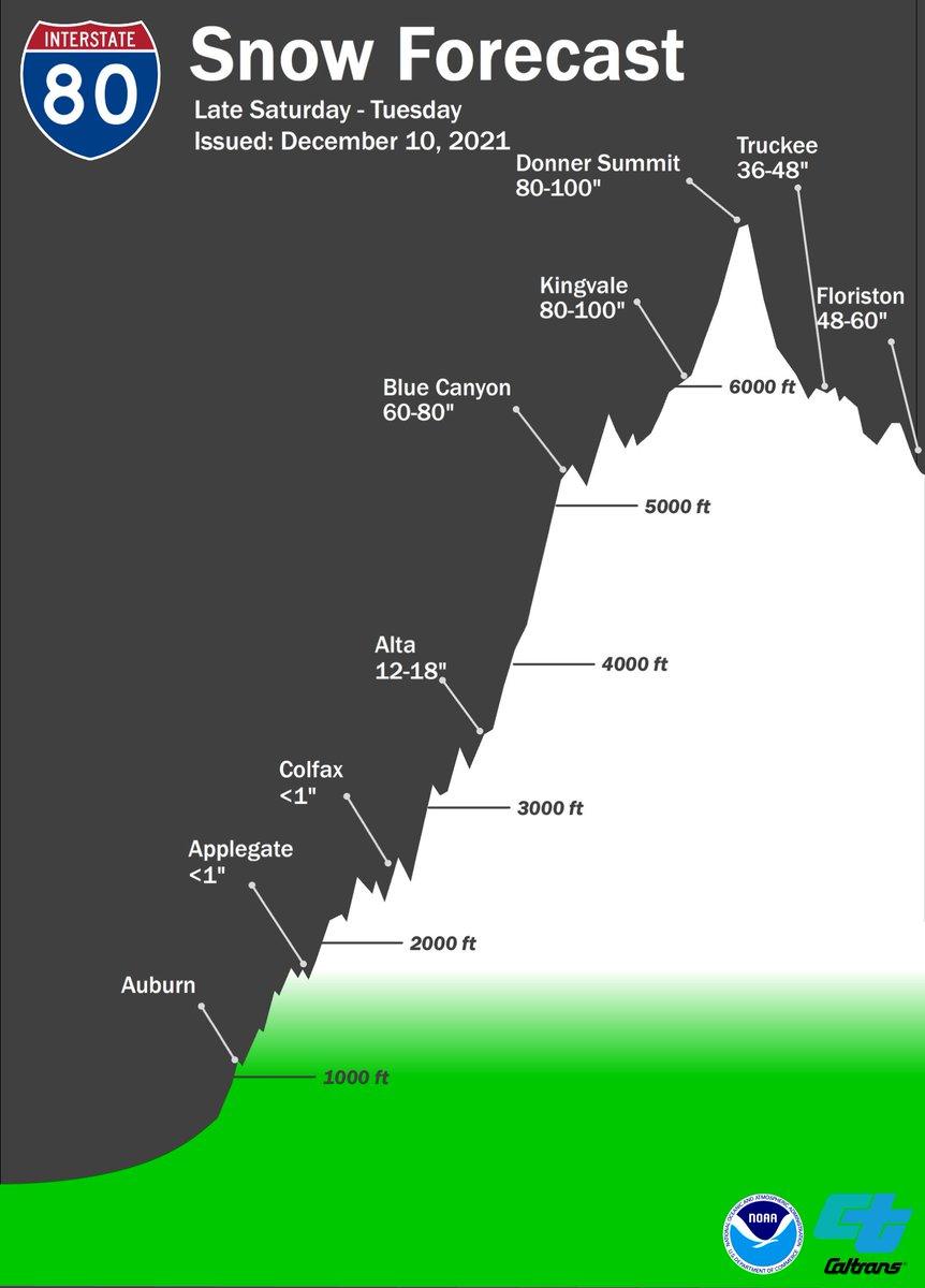
Our friends @NWSSacramento have just issued new snow forecast graphs for the upcoming weather system: 80-100 inches at Donner Summit on I-80 and 60-80 inches at Echo Summit on U.S. HWY 50 🥶😱 We highly advise limiting travel to before or after the storm!!
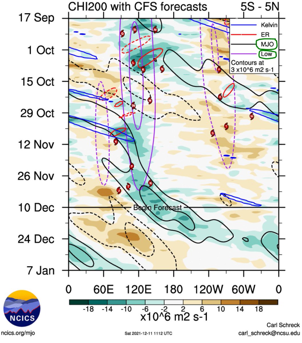
As several have already pointed out already, the #MJO is about to finally break through into the Pacific and resume normal progression. Looking at upper-level divergence, it seems to be able to do so as the #LaNina standing wave ("Low") weakens, and MJO takes over.
@Bubblespotting I am not sure you understand the meaning of @judah47's phrase "supersonic #PolarVortex". Put mildly, it's not exactly bullish for #natgas! Such polar vortex keeps all the cold - near the pole. Nothing to do with the 2013 "Polar Vortex" winter, when the PV was out of place...