LIFTOFF OF ARTEMIS II
Carrying the hopes and dreams of millions as four of humanity’s bravest ride a great pillar of fire destined for the Moon, carrying the pride of nations.
📸 - @NASASpaceflight
The agency is looking at “testing new approaches and really being able to think outside of the box” to claw back improper payments, according to CMS COO Kim Brandt.
https://t.co/iBRa3us4rX
Severe Weather and Schools
🏫 I have had a lot of questions about what schools may do with the high risk for storms and possible tornadoes Monday.
😀 Be Prepared, Not Scared.
⛈️ 🌪️ Dangerous Weather is
‘Possible’ - NOT Promised!
🫡 Respect the power of weather and have a plan. That is the premise for my school program: STORM SMART
🤷🏻♂️I Do Not Know what each district may do with schedules.
⭐️ AACo in MD announced 2 hour early close just as I posted this.
👍🏻 What I do know:
👉🏻 Faculty are trained to keep kids calm and safe.
👉🏻 School buildings are mostly made with brick, concrete, and steel. THESE ARE SAFER than most homes.
🚌 Busses: May hold at school when specific alerts are in that area to keep kids safer.
🔔 In the past schools have closed early for extreme winds in addition to other high risks.
📣 ALERT TYPES: Know the difference:
⚠️ Watches will be issued when conditions are possible.
‼️ Warnings are issued when it is actually happening and tracked with specific towns in the path.
💨 🌲 Falling Trees are a concern in strong winds.
🔌 Power Outages are possible.
⚡️ 🔥 Live wires can spark brushfires.
🚒👩🚒 Jackie’s company ran two different calls for that this weekend.
📻 Weather Radios are still a great way to get warnings.
📱 I know my posts here and app alerts do lot always reach in school or at work.
🙏 Please know where you will get warnings and backup.
😀 Do NOT let fear take over. If you have a plan and know where info is coming from.
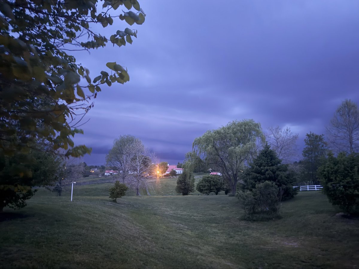
Good morning it's Sunday March 15
🚨 🙏 PLEASE THIS SERIOUSLY:
📝 Lots of maps and animations in my Full Report
🌀 ❄️ Blizzard in the Great Lakes Today will ALSO help Develop Severe Storms
⚠️ ⛈️ 🌪️ SEVERE STORMS PEAK MONDAY
❄️ May End With Snow Inland At Night
📍 Right Here In The Mid Atlantic
⏰ Focus Timeline
🏔️ Mountains Noon to 4 PM
💁🏻♂️ Metro Areas 4 PM to 8 PM
🌪️ Multiple Tornadoes
🧊 Large Hail 1” to 2”+
💨 Damaging Winds 60 to 75 mph
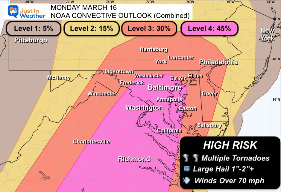
SERIOUS SEVERE WEATHER: The Storm Prediction Center has UPGRADED to a rare Level 4 out of 5 severe weather risk for Monday in the Mid-Atlantic. This includes Washington D.C., Richmond, Raleigh, Charlotte and part of South Carolina!
In the red zone, there is an increasing concern for a couple supercells that could produce an isolated EF2+ tornado, and given fast storm motions, we can't rule out a longer-track tornado as well.
This risk tier happens 3 times per decade on average in our area; the last times in D.C. were August 7, 2023 and April 19, 2019. These risk tiers are reserved for only the most substantial, higher-impact severe weather events that are somewhat reminiscent of what I chase out west.
Dangerous storms, some of which may produce 60-75 mph wind gusts, are likely. A few rotating supercells with tornado potential could crop up, and we'll also likely see a few brief spin-up tornadoes within the main squall line that should come through during the evening hours.
School districts – use Sunday to plan. Multiple rounds of potentially dangerous storms, including with some tornado risk, are likely in some spots.
HIGHER RISK MONDAY March 16 2026
🧵 1 of 4
‼️ LEVEL 4️⃣ of 5: This has been raised AGAIN and Is A Big Deal.
🌪️ ❄️ Multiple Tornadoes (possible) AND may end with Snow (again)
Lots of info here: This is Very Possible AND Not Promised.
🙏 Please know this is not hype. I would not do that.
My goal is to Make You Aware So You Can Prepare
AND NEVER TO SCARE!
WHY NOW?
🌀 A Blizzard in the Northern Plains/Great Lakes on Sunday will spark a line of severe storms in the Central US. This will peak in our region on Monday!
WHEN:
🪟 Time Window Noon to 8 PM
🏫 Schools: I do not make the call for them. In the past I have seen both staying in for shelter OR dismissing Early, even for damaging wind forecast.
👀 Stay on the lookout for official word for your place.
‼️ ALERTS:
WATCHES are Issued when the conditions are present for these storms to form. They cover a broad areas and often time window about 6 hours.
WARNINGS are issued when a storm with these conditions is actually happening. Then tracked through counties and specific towns in a shorter window of time.
🌪️ Multiple Tornadoes are possible
🧊 Hail OVER 1" diameter is standard criteria for a storm to be considered 'Severe'
💨 Winds OVER 58 mph is standard criteria for a storm to be considered 'Severe'
⚡️ Lightning can be dangerous in any thunderstorm, even if not severe.