I can compile all the wrong tweets you have posted, even if you have deleted them, and expose the truth. Don't make me do that.
If you love blogging, post whatever you want about the weather and let the public benefit from your insights.
But when all your posts are nothing but potshots at someone else, driven by jealousy, it reflects poorly on you. The more jealous you get, the deeper you dig your own pit.
Can you boldly predict whether it will rain or not before the event? Instead, you keep saying, “Let’s track it in real time.” Even the common public knows how to track rainfall in real time!
Once the event is over, you come forward with potshots and criticism. The real test of a weather blogger is to make a forecast before the event and not to analyse everything in hindsight.
And the cup goes to Person A from Vadakupatti
Person A: One guy predicts sorry he does nowcasts only of no rain for all 365 days. Even when it rains, he never predicts it. He is technically correct on around 300 days.
Person B: Another guy predicts rain on 60 out of 365 days. He gets those 60 days right but misses around 5 rainy days.
The winner is Person A, because he is right on 300 days vs 60 days of Person B, so winner cup ungalukku thaan vadakupatti sir !!!
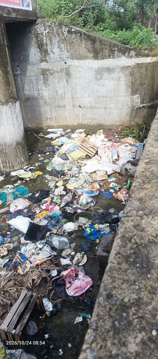
வடகிழக்குப் பருவமழை அதிகாரப்பூர்வமாகத் தொடங்கி, அதன் தீவிரம் படிப்படியாக அதிகரித்து வருவதால், பீர்க்கங்காரணை ஏரி நீர்வரத்து மற்றும் நீர்வெளியேறும் பகுதியின் நிலையை உங்கள் உடனடிக் கவனத்திற்குக் கொண்டு வர விரும்புகிறேன்.
@Tambaram_Corp
TWM Weather Watch - CYCLONE ARNAB vs ARABIAN SEA LOW — Nature's own Prime Time Fight Night !!
=================
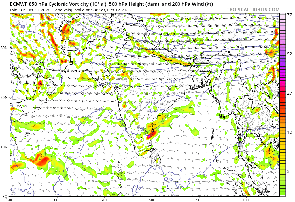
Bay of Bengal la irundhu Arnab entry kudukkararu! Arabian Sea la irundhu Low Pressure counter attack pannudhu!
THE FIGHT: Arnab wins the battle! He drags the Arabian Sea Low towards him and finally swallows the low pressure system.
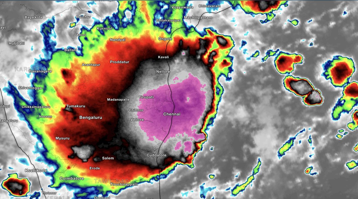
OUTCOME: Tamil Nadu ku adutha 2–3 days semma weather action days ku irukka pogudhu. Just look at the images to understand why the next 2–3 days could be massive for Tamil Nadu!
This post is purely for educational purpose for common man to understand how two systems both sides play out.
Heavy Rain Batters KTCC
---------------------------
Once again many centuries across #Chennai with Chennai City scoring 107mm and Chennai AP 120mm. This Lpa turns out to be really good with widespread heavy rains in most parts of the city. City reached its October normal with yesterday's spell and a good start to NEM 2026.
Forecast for today
--------------------
On and off moderate rains to continue over the city. Rains will reduce gradually from tonight or tomorrow morning. Pls do carry an umbrella ☔ or a raincoat if you are going out.
South TN will get heavy to very heavy rains today. Coastal TN and adjoining interiors will get moderate to Heavy rains.
Rains Stats across Chennai
-----------------------------
Vadapalani 135mm
Saidapet 128mm
Kolapakkam 125mm
Alandur 122mm
Madipakkam 116mm
Valasaravakkam 115mm
Anna nagar 107mm
Adyar 106mm
Icf 95mm
Korattur 92mm
Pws
-----
Kk nagar 127mm
Pammal 114mm
Neelangarai 107mm
Kws nunga 96mm
Chromepet 90mm
Royapettah 89mm
Ayapakkam 88mm
West Tbm 78mm
#ChennaiRains #TNRains #NEM2026
What a joke!! Unnecessary panic created among common public today when the real threat was yesterday.
The red alert is frequently misused across media outlets to generate hype and gain traction. When genuine rain arrives, no one bothers to alert.
#Chennairains#Monsoon2026 #SWM2026
It’s funny how few people attempt to explain that this was not a 'CLOUD BURST' when the reasoning is quite simple.
Here are some figures from yesterday’s thunderstorm event:
Kathivakkam: 149.1 mm between 9:30 PM and 10:30 PM
Sathangadu: 106.4 mm between 5:30 PM and 6:30 PM
KK Nagar (Private) - 101.3 mm between 11:30 PM and 12:30 PM
Parrys: 98.3 mm between 6:30 PM and 7:30 PM
Many more private AWS stations recorded close to 100 mm of rainfall in an hour. If this isn't a cloudburst, I don't know what is.
#Chennairains #Monsoon2026 #NEM2026
Reviewed the sounding values logged at Meenambakkam Airport in Chennai yesterday at 12Z.
CAPE: 3043 J/kg indicates very high instability, promoting strong updrafts and persistent thunderstorms.
CIN: -8 J/kg suggests storms may develop readily with minimal inhibition.
PWAT: 68.1 mm suggests the atmosphere held substantial moisture.
Combined with indicators such as the Lifted Index, K index, and SWEAT index, conditions were favourable for such a robust environment. All these real-time, localised atmospheric readings, together with mid-level cyclonic circulation over north Tamil Nadu and upper-level trough influence, produced such an imaginable downpour!!
In short: the atmosphere was primed for heavy thunderstorms. High instability, extremely high moisture, and larger-scale weather systems across the north TN belt combined.
#Monsoon2026 #NEM2026 #Chennairains #Tamilnadu #Thunderstorms
Aduvana thappu solli solliyae munarum nenaikkum jeevan naan illai. I already have enough on my plate, with elderly parents to take care of and a job that is as hectic as it gets. All these posts, data compilation all done during my free time. Before passing judgmental comments, please remember that.
I am minding my own ways and choosing to ignore the negativity. I don't seek recognition, nor do I want to be the face on TV during heavy rainfall events. All the major news channels know this. I rarely accept TV interviews; only when they persistently request and it happens to be a leave day do I agree.
But I won't lie, a few encouraging and kind words from people keep me going. That's why I still try to read the comments.
To be honest, weather blogging isn't as enjoyable as it was in 2015. Those who have known me for a long time understand what is in my heart. Jealousy, the race to be the first to post, arguments over who is right, things have changed. The joy and spirit that once made this space special seem to be fading.
I would rather work behind the scenes, sharing my interpretations and making sure people and the Government can use them to the best of their ability. That is what matters to me, not publicity or recognition.
Regarding yesterday's rains: Yes, we had predicted that it was an ideal day for rainfall across North Tamil Nadu and Chennai. But if you had asked me yesterday morning whether Chennai could receive 300 mm of rain, I would have said there was a 0% chance. The broad setup was favourable, but the sheer magnitude of the rainfall was beyond what I expected.
Weather will always have its surprises. I will continue to share my interpretations honestly, acknowledge what I get right and what I don't.
It's incredible how this weak cyclonic circulation located directly over north Tamil Nadu has created extremely favourable conditions for severe storm activity, resulting in very heavy to extreme rainfall across most parts of Chennai right now. The attached chart is a 700 mb wind chart showing strong vorticity over the KTCC zone. This usually leads to sustained storm development and severe downpours. You can actually see the spin occurring right above us. These are the situations where models often struggle to make accurate predictions, as real-time atmospheric conditions play a crucial role.
In the meantime, Parrys in North Chennai has recorded 197 mm in just 3 hours. This is severe on every level. Radar images show that more storms are developing all around Chennai. Avoid travelling outside in these situations.
#Chennairains #Monsoon2026 #NEM2026 #Tamilnadu
Parrys 175 mm
Sathangadu 140 mm
Kargil Nagar 121 mm
Thiruvottiyur 115 mm
Kathivakkam 92 mm
Tondiarpet 88 mm
Just insane!! One storm can change the tables completely.
#Chennairains#Monsoon2026#NEM2026#Tamilnadu