Snow is falling across the Parklands and Interlake this morning, but just a few flurries are occurring farther south. It looks like the bulk of the snow will end up a bit farther north than expected, giving only light amounts for most of southern Manitoba today and tomorrow.
There is a slight chance of reaching 20c in Winnipeg tomorrow. Upper teens for sure.
It is not unusual to reach 20c in April historically. From 1991-2020, average date of first 20c in Winnipeg is about April 22. In fact, on average 3 days in April reach 20c.
Satellite image over Wpg shows lots of mid level cloud but some brighter patches to the south and southeast. The flow is from the southeast generally. #Eclipse2024
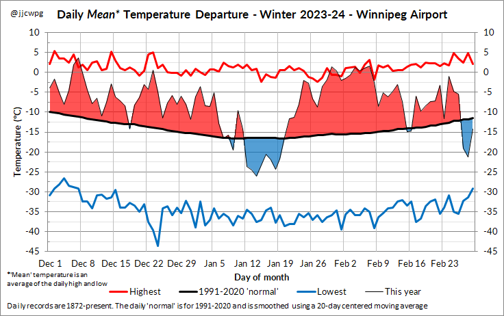
It was the 2nd warmest winter on record in Winnipeg (December to February). Only 1877-78 was warmer, 146 years ago. It may be a while before we experience a winter like this one again.
- Fewest days below -20°C (tied with 1877-78)
- Only 1 day below -30°C
- 6.3°C above normal
January was another very warm month in Winnipeg:
🌡️ Mean temperature: -12.1 C (4.2 C above normal)
❄️ Total snowfall: 29.8 cm (4.2 cm above normal)
This winter currently ranks as the 3rd warmest on record, but it's still well shy of 1877 which holds the title for warmest ever.
Winnipeg just missed today's daily record. The high was 4.7 C at the airport, 0.3 C shy of the 5.0 C record. The provincial hotspot was McCreary again, with a high of 12.1 C. #mbwx
13 C in Grand Forks today and 17 C in Fargo. Winnipeg’s high was 8.6 C which is the 8th warmest December day since 1872 and a daily record high. There have been 4681 December days since records began, so 8th out of 4681 is pretty impressive!
“What they hate in you is missing in them. Keep shining” @global_leslie You are beautiful inside and out, and that’s what bothers them most. Love watching you and love seeing all the great things you do for our city. ❤️