The Japan Meteorological Agency warns of an increased risk of a magnitude 8.0+ earthquake within the next week and is urging people to evacuate now. #tsunami
A #tsunami warning has been issued for Iwate and Hokkaido downgrade following a powerful earthquake off the northeastern coast of Japan, triggered off the east coast of Honshu.
Super #Typhoon#Sinlaku slams Saipan with destructive winds and blinding rain.
Conditions are rapidly deteriorating as this powerful storm batters the Northern Mariana Islands.
#Typhoon#Sinlaku is beginning to lose some of its punch, weakening to a Category 4 storm as it moves past the Northern Mariana Islands. Satellite imagery shows a fading eye and warming cloud tops—but it remains a large and dangerous typhoon.
#Typhoon#Sinlaku is tracking generally west-northwest toward the Northern Mariana Islands at landfall, where significant impacts are expected, including destructive winds, heavy rainfall, storm surge, and dangerous seas with 145mph and a central pressure of 930 mb.
#TyphoonSinlaku is currently located east-southeast of Guam and is moving generally northwest toward the Mariana Islands. It has reached super typhoon strength, featuring a well-defined eye surrounded by intense deep convection and a tightly organized CDO structure.
#SuperTyphoonSinlaku rapidly intensified into a powerful Category 5-equivalent system, with sustained winds of around of 150 knots (175mph) and a central pressure of approximately 902mb.
🌬 China acaba de registrar la ráfaga de viento más fuerte del año. Una supercélula arrasó el condado de Daishan, en la provincia de Zhejiang. Los vientos máximos alcanzaron la asombrosa cifra de 54,8 m/s (122 mph).
📹 @yangyubin1998
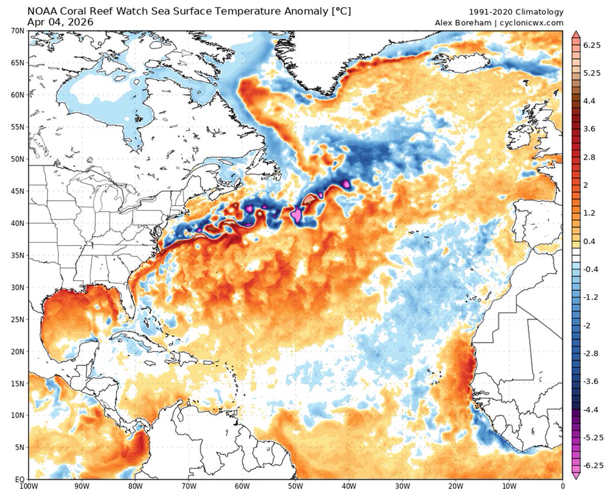
The Caribbean is slightly warmer than normal, while the eastern and central tropical Atlantic are slightly cooler than normal. This pattern of Atlantic sea surface temperatures provides mixed signals regarding the potential for an above- or below-normal Atlantic #hurricane season
New maps causing meteorologists to lose their minds in disbelief at massive heat build-up in the Equatorial Pacific
The oceans will not literally be boiling red 🔴 in the early autumn, but the Super El Niño will drive unprecedented global extreme weather events.
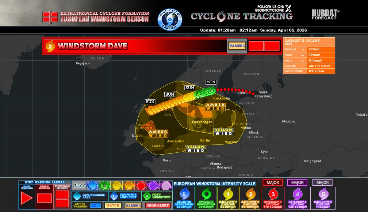
Post-#StormDave Final Advisory 9
Winds: 60mph
EWSIS: ex-WS
MSLP: 981mb
#Dave is currently located near or over the coast of Rexvågen, affecting southern Sweden, and has become a post-windstorm tonight. This is the last advisory. More details on image description...
#StormDave Advisory 8
Winds: 80mph
EWSIS: C1
MSLP: 980mb
#Dave is currently moving towards Dalarna County, Sweden, with strong winds affecting central and southern regions. More details on image description...
#StormDave Advisory 7
Winds: 80mph
EWSIS: C1
MSLP: 979mb
Dave is currently affecting the region, with the storm system expected to gradually weaken as it moves northeastward across Rudssætra, Norway...
#StormDave Advisory 6
Winds: 85mph
EWSIS: C1
MSLP: 979mb
#Dave is currently classified as a Category 1 cyclone, is making its way across Europe and is headed towards Buskerud and Innlandet in Norway...
#StormDave Advisory 5
Winds: 90mph
EWSIS: C2
MSLP: 978mb
#Dave is currently moving toward Norway, bringing damaging gusts, heavy rain, snow, and coastal flooding to areas in southern Norway and northern Denmark today, with the storm expected to gradually weaken later...
#StormDave Advisory 4
Winds: 100mph
EWSIS: C2
MSLP: 972mb
#Dave is currently tracking toward the northeastern coast of Europe. The storm is moving toward the North Sea and is likely to affect the coastal regions of northern Germany, Denmark, and possibly the Netherlands...
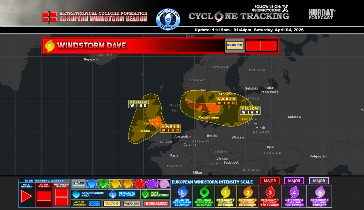
#StormDave Advisory 3
Winds: 90mph
EWSIS: C2
MSLP: 974mb
#Dave is expected to track across North Sea, strengthening as it moves toward Scandinavia. Increasing winds & coastal impacts are likely from late Sunday into Monday, particularly across southern Norway, Denmark, and Sweden
#StormDave Advisory 2
Winds: 85mph
EWSIS: C1
MSLP: 978mb
#Dave is expected to move northeast across Northern Scotland tonight, bringing moderate to strong winds, especially across the UK and parts of northern mainland Europe from Easter Sunday into Monday...
Overall, this windstorm represents a moderate to high-impact event, with conditions gradually improving as the system tracks further into northeastern Europe.
#StormDave is impacting parts of northern and western Europe, bringing widespread strong winds and hazardous conditions from Saturday night into Easter Sunday.