I used to❤️Twitter as a place to genuinely connect & learn from others. It's not that place anymore. I uninstalled Twitter in April'22 & have decreasingly used it. Other platforms haven't worked as a replacement; hoping Bluesky will be diff. Join me here: https://t.co/AwTonaZbb8
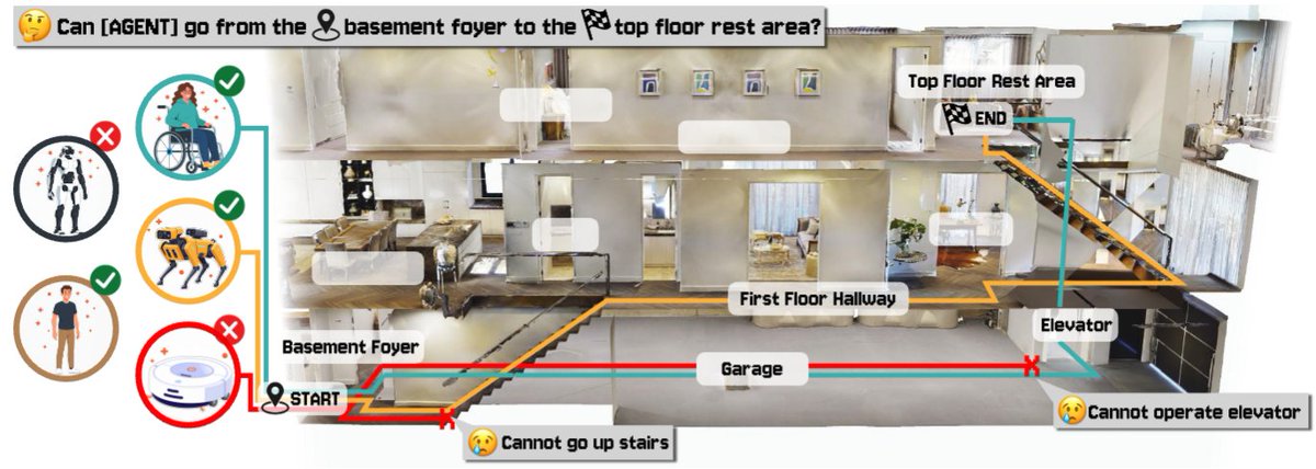
🚀 Excited to share that our paper “CapNav: Benchmarking Vision Language Models on Capability-conditioned Indoor Navigation” has been accepted to #CVPR2026 (main track)!
📄: https://t.co/ZdSpsMPBJY
💻GitHub: https://t.co/1XkvpxywEY
🤗Hugging Face: https://t.co/LzQ77EykX4
(1/4)
StreetReaderAI leverages context-aware AI to solve a critical accessibility barrier, making immersive street-level imagery interpretable by screen readers. This work is the path to fully inclusive digital exploration.
Delighted that our work is being featured. This was an incredible team effort by a set of hugely talented, passionate Googlers: @shaunkane, @AlexFiannaca, Victor Tsaran, Nimer Jaber, & Phil Nelson. An accessible street view has enormous potential for blind travel planning and O&M
Introducing StreetReaderAI: A new and more accessible street-level imagery prototype using context-aware, real-time AI and accessible navigation controls. We're redefining immersive streetscape experiences to be inclusive for all with multimodal AI. More: https://t.co/CRlZH3Svhh
I have had the incredible privilege to sabbatical at Google Research. What have I been up to? Attempting to make Street View accessible to all! 🌍✨
StreetViewAI is a new, accessible street view prototype using context-aware AI & voice interaction.
https://t.co/VwpK2YKJe7
On a personal level, this project was like a sabbatical dream 🦄, I got to reunite with @shaunkane
(we first worked together in 2006), collaborate with some incredible Googlers like Alex Fiannaca, Nimer Jaber, & Victor Tsaran, and even write (lots of) code in Google's monorepo 🧑🏽💻
We're launching RampNet, an open-source AI that helps detect curb ramps with near-human accuracy. The most amazing part?
The entire project was conceived of and led by high school student John O'Meara.
🧵 A thread on what we built and why it matters.
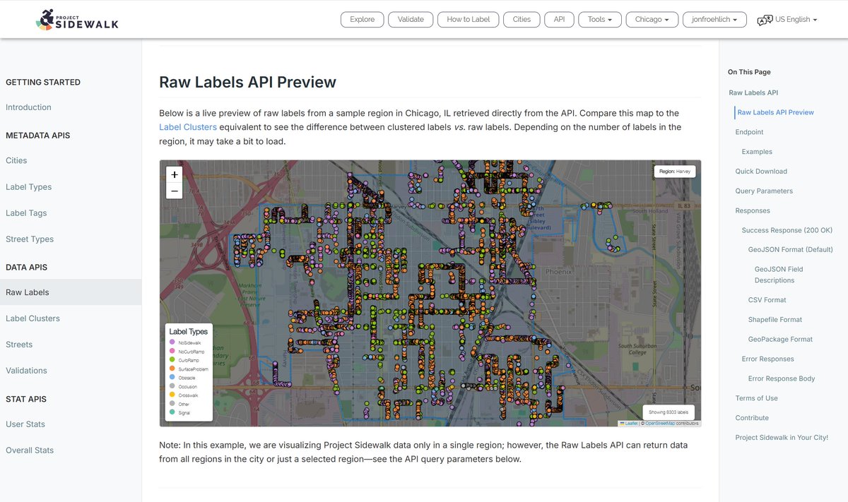
📢We've completely redesigned our API pages! It's never been easier to:
✔️ Download data in CSV, GeoJSON, or Shapefiles.
✔️ Access data programmatically through our revised API.
✔️ Build tools that champion accessibility & improve urban mobility.
https://t.co/b7Ge1JSiYE
Can your robot vacuum do this? Researchers in @UW@uwengineering#UWAllen’s @makeabilitylab adapted one to create MobiPrint, a 3D printer on wheels that maps a room and prints objects on location, on demand based on a user's needs. #UWinnovates#NSFfunded https://t.co/u7p59MzAv4
Thrilled to be heading to #ASSETS24 to present “Engaging with Children’s Artwork in Mixed Visual-Ability Settings”, done with my wonderful collaborators and advisors @wobbrockjo and @jonfroehlich! I will be presenting on Mon, Oct 28 as a part of Session 1A: Creativity 🖼️🎨 (1/7)
Chu Li is a fantastic, multi-talented PhD student seeking an internship for Summer'25. She will level-up any group that she joins. See: https://t.co/FoXNZBeYFp
For the last decade+, my group has developed new interactive tools to advance understanding of the accessibility of the physical world for people with disabilities—projects like AccessScore, AccessVis, and Sidewalk Equity.
One step towards this future is Chu Li's (@Chimichurrichu) new VIS'24 tool AltGeoViz, which attempts to provide interactive high-level spatial analytic summaries verbally via screenreader I/O controls.
https://t.co/GWwOXcYtqg