More severe storms are likely in the Great Plains tomorrow, mainly centered from Denver to just north of OKC. There, potential for significant severe wind and severe hail exists from afternoon storms. Tornado potential will be concentrated around Cheyenne and Denver where a small 2% has been issued. Supercells are possible in this area before they congeal into messy segments capable of significant wind primarily.
Approximately 110 million people are under threat for severe storms today from Billings, MT to NYC. A three headed slight risk is in place. One for the Central high plains where giant hail and isolated tornadoes are possible from supercells growing into li ear clusters later on today.
Wind is a much bigger threat for the eastern half of the risk, including the small sliver of slight risk in Texas and Arkansas. Two small areas of tornado potential exist. One from South TN, northern Mississippi and northern Alabama and another in the northeast including Maryland, all of New Jersey and east Pennsylvania. Today shouldn’t be nearly as busy tornado-wise as yesterday was!
When looking at tornado reports so far for 2026, one state in particular stands out.
Illinois has a total of 196 tornado reports right now, which blows its previous record of 139 set in 2024 out of the water. This also destroys the annual average number of tornado reports which sits at 54.
More tornadoes are likely to be confirmed across the next few days which will likely push this number over 200, and it’s only June 😳 .
As a country, the US is currently above average for this time of year on tornado reports, despite a relatively quiet year in the plains. This is because of the Midwest and especially Illinois having so much tornado activity.
The active season is likely to continue through the summer as we approach a typically active timeframe for severe weather in the Midwest. Illinois may see more severe storms beginning late this week. Attached is the tornado probability forecast verification for yesterday. We could have verified much higher probabilities! Maps via SPC
Tornado Warning for... North Central Weld County in northeastern Colorado...
* Until 815 PM MDT.
* At 735 PM MDT, a severe thunderstorm capable of producing a tornado was located 11 miles northwest of Pawnee Buttes, or 50 miles north of Fort Morgan, moving east at 25 mph.
HAZARD...Tornado and half dollar size hail.
SOURCE...Radar indicated rotation.
IMPACT...Flying debris will be dangerous to those caught without shelter. Mobile homes will be damaged or destroyed. Damage to roofs, windows and vehicles will occur. Tree damage is likely.
* Locations impacted include... Mainly rural areas of North Central Weld County.
We’ve had a marathon of live coverage over the past couple of weeks, reaching over 12 MILLION people on live streams alone!
I’m incredibly grateful that we’re able to help so many people with life-saving weather information when it matters most. Thank you to everyone who has shared our mission, our story, and our coverage with your friends and family.
It truly makes a difference, and your support helps us continue improving our live coverage so we can reach even more people during dangerous weather.
From the bottom of my heart, thank you.
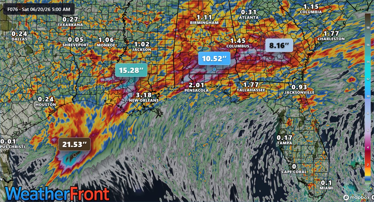
Tropical Storm #Arthur is the first named storm of 2026 in the Atlantic Basin.
The main impacts from this storm will be dangerous flooding from heavy rainfall along the Gulf Coast. Several hi-res models paint isolated totals over a FOOT of rain through the end of the week.