SeminoleSAFE (a.k.a. KeepFSUSafe) is your source for safety information, preparedness education, crime prevention tips and more from Florida State University.
7 AM ET 6/1 - We're not expecting widespread showers & storms today like we've seen over the last few days. This will allow afternoon temps to remain hot, increasing our heat risk with minor to moderate impacts likely. Take precautions to prevent heat-related illness. ☀️
5:30 AM ET 5/28: A messy, unsettled pattern continues through early next week. Keep the umbrellas and raincoats handy as rain chances remain very high into early next week. Some heavy rain, frequent lightning, and gusty winds are possible in the stronger storms. #ALwx#FLwx#GAwx
🤔 Caught in a #RipCurrent?
⚠️ DO NOT PANIC!
🌊 Relax & float to conserve energy
🏊 Good swimmer? Swim parallel to shore until you clear the rip current
🤷 Not a skilled swimmer? Flip on your back & float.
📣 WAVE & YELL to get the lifeguard's attention
🌟 Be #BeachSmart
👀 See someone caught in a #RipCurrent?
⚠️ Beachgoers that attempt a rip current rescue by themselves or as a human chain may end up needing to be rescued
🏊 Rip currents can be deadly - even for the most advanced swimmers
📞 Instead - Call 911 and throw them a flotation device
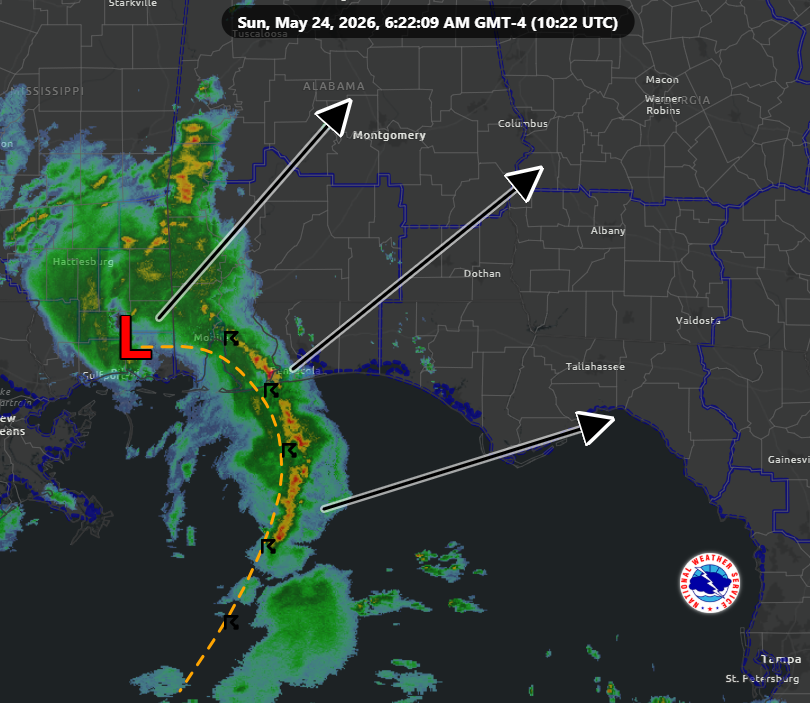
Another round of showers & storms today. A loosely-organized complex moving in from the Gulf will track NE across the tri-state area. Widespread severe weather isn't expected, but isolated damaging winds up to 60 mph & small hail are possible. ⛈️ #FLwx#GAwx#ALwx
May 21, 2026
We are entering a warmer and wetter pattern. Heat Indices (feels-like temperatures) will be in the upper 90s to 100°🌡️. Rain chances⛈️ also increase heading into the holiday weekend.
#FLwx#GAwx#ALwx
5/11 630am ET - A few strong thunderstorms are expected today, bringing familiar hazards such as gusty winds, dangerous lightning, small hail and brief torrential downpours. Head indoors when storms approach. #FLwx#ALwx#GAwx
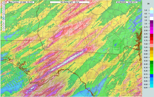
5/9 5:30a ET - Inland areas received hearty rainfall over the last 2 days. In contrast, coastal communities and the SE Big Bend have come up short. Here's a map of radar-estimated rainfall and a table of observed amounts for Thursday and Friday combined. #FLwx#GAwx#ALwx
5/8, 615 am ET: There's a Marginal Risk (Level 1 of 5) of severe thunderstorms each day through Sunday. Be ready to head indoors when storms approach. Main threats are strong gusts, lightning, torrential downpours, and hail. #FLwx#GAwx#ALwx
A Severe Thunderstorm Warning has been issued for the FSU Tallahassee campus. Stay inside. If caught outside, take shelter in a sturdy enclosed building or hard top automobile immediately. Avoid open spaces, isolated objects, high ground and metallic objec https://t.co/8AiSXFSHHk
5/7 2 AM Update:
Slight Risk (Level 2 of 5) across the area today. Damaging winds are the primary concern, but a tornado or two & hail are also possible. The timing is generally this morning into the afternoon before the storms weaken as they head southeast.
#flwx#gawx#alwx
5/7/26 3 AM EDT UPDATE:
Tornado WATCH now in effect for all of southeastern Alabama, the Florida Panhandle, western Florida Big Bend, and much of southwestern Georgia until 10 AM EDT/9 AM CDT.
#alwx#flwx#gawx
4/27/26 8AM ET 🔮⛈️
The next 3 days will feature warm/dry wx Mon-Tue with increasing (beneficial) rain chances ahead of a front on Wed. Thunderstorm potential also jumps - some may be strong to locally severe. Stay tuned.
#FLwx#GAwx#ALwx
4/24/26, 6 am ET. Although some rain is returning to the forecast this weekend, the forecast amounts are generally under an inch. This will do very little to alleviate our ongoing significant drought, although the rain will be welcome in areas that see it. #FLwx#GAwx#ALwx
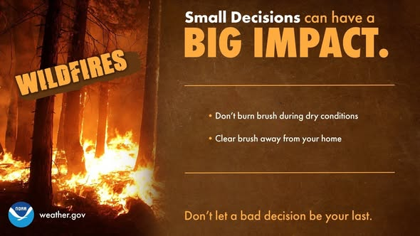
4/18/26 8AM ET 🔥🚩⚠️ #FLwx#GAwx#ALwx
Record-near record high temps, ongoing significant drought, and low humidity will make for high fire danger today.
A Red Flag Warning has been issued for parts of the FL Big Bend & SW GA. Outdoor burning is highly discouraged!
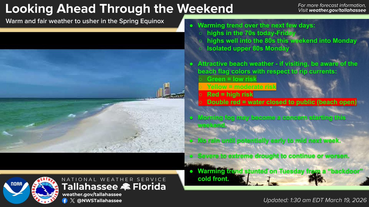
3/19/26 6AM EDT 🥶🌡️📈🫗🏖️🌫️
Notable warming trend to follow a chilly and frosty morning. Fair weather prevails thru at least this weekend. Somewhat fitting way for the Winter Solstice to give way to the Spring Equinox. 🫴
#FLwx#GAwx#ALwx
🍀 When it comes to your pets & livestock, don’t leave it up to luck — be prepared.
🐶 Include your animals in your disaster plans & make sure you have a safe way to transport them if evacuation becomes necessary.
➡️ Visit https://t.co/1pVy3rfrS9 to get started.
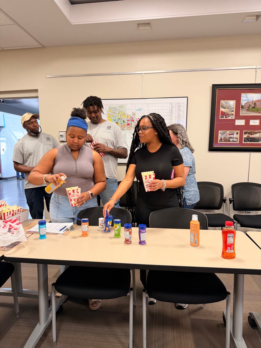
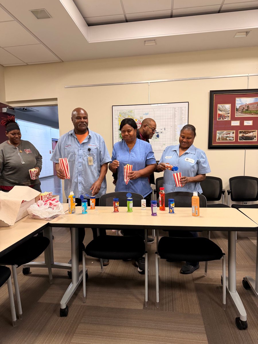
A little popcorn, a lot of appreciation 🍿
Facilities HR hosted a popcorn pop-up to thank the hardworking teams who keep the campus running every day. It’s a small gesture to recognize the big impact the Facilities staff makes across FSU!
#FSU
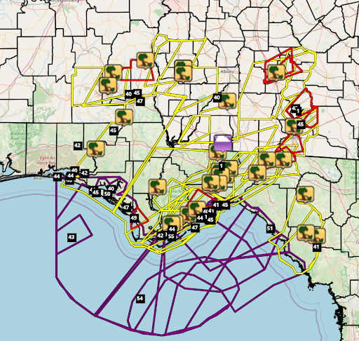
3/16/26 955PM EDT ⛈️⚠️📋
Scattered to numerous storms produced severe wx and some heavy rain today. Many Warnings were issued. A flurry of storm reports came in: downed trees, 40-50+ mph gusts. There was at least 1 radar-confirmed tornado in Madison Co., FL.
#FLwx#GAwx#ALwx
Starting at 9 a.m. on Tuesday, March 17, through Thursday, March 19, at 5 p.m., weather permitting, there will be a road closure of Old Bainbridge Road between Westbury Dr. and Trevor Ct. This closure is to replace a crossdrain. For more information, visit https://t.co/W50eAIxfBZ