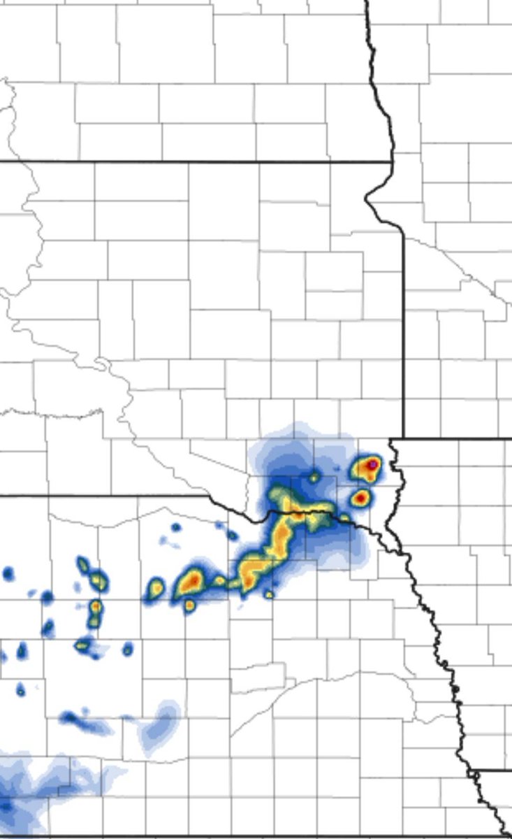
Severe storms remain possible on Tuesday.
These storms will push into the area Tuesday evening and persist into the night.
Large hail to 2 inches+, damaging winds to 75 mph, and an isolated tornado are all possible.
Make sure to have multiple ways to receive warnings!
Strong to severe thunderstorms will be possible late this afternoon into the evening. The better chances will be near highway 14. Heavy rain will also be a threat with these storms.
⚠️ Another round of severe weather (area in green), is possible later today into the nighttime hours. We are tracking storms expected to develop across Nebraska between 5–6 PM, then push northeast toward the Sioux Falls area around 10 PM.
The primary threats with these storms will be heavy rainfall, hail, and strong winds. At this time, there is no tornado risk outlook with this system.
As storms begin to develop and warnings start to be issued, remember — Tea Storm Chasers will be here tracking it every step of the way to help keep you informed and weather aware. Stay tuned and keep those notifications turned on! ⛈️🌩️
#TeaStormChasers #SDwx #WeatherAware
🚨🚨🚨ALERT🚨🚨🚨
Lyon County Urgent Missing Person Alert: BOLO 92-year-old FEMALE, GERTRUDE VANDENTOP, last seen 2:15 pm today, may be lost, has dementia, Does NOT have a cell phone, last seen driving WHITE 2009 BUICK LUCERNE with Iowa plate NQG605 in the HULL area. If located call the Lyon County Sheriff’s Office.
⚠️ SEVERE WEATHER PREP TIME: The time to prepare is NOW. Sunday and Monday could bring impactful weather across parts of the region, and waiting until storms are already developing is too late.
Make sure you and your family have multiple ways to receive warnings. Don’t rely only on outdoor sirens — stay ahead of the storm with alerts that go directly to you. ⛈️🌪️
📞 NOW is the time to sign up for our call alert system!
Get critical weather alerts sent directly to you.
Sign up today: https://t.co/dRjV7MgN6O
A few minutes of preparation now can make all the difference later. Stay weather aware and be ready. #SevereWeather #WeatherReady #TeaStormChasers
It's that time of year!!! GARAGE SALE season!!!
Didn't sell everything you were hoping to sell? Don't worry, we got you covered!!
We are launching our first ever garage sale pickup service!!!
Confidence continues to increase in showers and thunderstorms returning by Thursday. A few storms could become severe mainly east of I-29. With this in mind, make sure to monitor your local forecast and have multiple ways to receive warning information.
One person is dead and another two remain unaccounted for after a seven-story parking garage under construction in Philadelphia partially collapsed on Wednesday, officials said. https://t.co/X6ltek6WEL
POTENTIAL SYSTEM THURSDAY
We are watching a potential disturbance that could bring rain and snow to the region on Thursday! This is NOT expected to be a big system, but there could be some mixed precip. This will be something we will continue to monitor so stay tuned for updates!
Next round of rain and wintry mix spreads into the area late tonight, continues thru the day Friday, and gradually tapers off Friday night into early Saturday.
Slick roads are likely north of Interstate 90 into Friday.
Most icing will occur on bridges, overpasses, and trees.
‼️‼️MISSING SIOUX FALLS TEEN‼️‼️
EZRA HOWARD
Missing Since 2/13/2026
Age Missing: 17
Agency: Sioux Falls Police Dept
Phone: 605-367-7000
Race: White
Sex: Male
Eyes: Brown
Hair: Blond or Strawberry
Height: 5'6"
Weight: 125
Remarks:
Ezra's hair is dyed blond with some purple in it. Ezra was last seen wearing a sweatshirt, black jeans and a mask
All Missing person reports are directly from the Attorney General Missing Database, via the law enforcement agency listed.
https://t.co/o9UYJiXNgF
Shared by South Dakota Missing and Unidentified Persons
https://t.co/9RwqavXNZr
Post are updated when law enforcement has made contact and removes the individual from the missing database ONLY
Here’s an updated look at overall amounts for our area. While a couple inches of wet snow will be possible along the highway-14 corridor, the main concern continues to be in the potential for icing accumulations across southwestern MN and east-central SD.
While most areas won’t start seeing precipitation until mid-morning, it will likely come in the form of rain or snow depending on surface temperatures. However, a transition to wintry mix by tonight could lead to some ice accumulations so make sure to monitor your local forecast!
While some spotty light precipitation is likely to start forming near Highway 14 late this afternoon, the main snowfall will occur tonight from later evening into the early overnight. Greatest snowfall in SW MN, but light accumulations will be seen most areas.