One thing I've seen people misunderstand: this isn't just a problem for the areas missing balloon launches. Those observations help initialize the forecast models, and any missing data can degrade forecasts far downstream as the model evolves. If you're in Ohio, you should care just as much about a missed launch in Montana as someone who lives there.
Flash Flood Emergency in Madison County, Kentucky. 3 to 7 inches have already fallen and flooding is happening right now. Get to higher ground immediately, and do not drive into any water on the road.
Water rescues are already happening in McKee, Sandgap, and Clover Bottom, Kentucky. This is a Flash Flood Emergency. Get to higher ground right now, and do not get in a car unless you are fleeing.
WPC has a Moderate flood risk on the map today, their second-highest, for parts of Missouri, Oklahoma, and Kansas.
The core sits near the Springfield area down toward Rogers and over by Stillwater. Storms keep parking over the same towns, and after this week the ground just can't soak up any more, so it runs straight to the roads.
If you're in there today, give yourself extra time and never drive into water across a road. You can't tell how deep it is.
FLASH FLOOD EMERGENCY for Wichita, Kansas! Between 3 and 5 inches of rain have already fallen, with an additional 1 to 3 inches expected! Get to higher ground NOW!
Flash Flood Emergency for Wichita, Derby, Andover, Haysville, and Mulvane. 3 to 5 inches already down with more coming. Get to higher ground right now, not in a minute. I'm live on this: https://t.co/GG1wJZhsqx
FLASH FLOOD EMERGENCY for Wichita, Andover, Derby, Haysville, and Mulvane until 4 AM CDT. CATASTROPHIC, life-threatening flooding ongoing now; 3-5" already down with more coming. SEEK HIGHER GROUND IMMEDIATELY. Ryan's tracking LIVE: https://t.co/Fsv9FWPFpH
Flash Flood EMERGENCY for WICHITA, ANDOVER, HAYSVILLE, MULVANE, AND DERBY.
Southwestern Butler County in south central Kansas...
Southeastern Sedgwick County in south central Kansas...
* Until 4:00 AM CDT.
Turn around and DON'T DROWN.
* Tornado Warning for...
Central Collingsworth County in the Panhandle of Texas...
Northeastern Donley County in the Panhandle of Texas...
* Until 10:45 PM CDT.
Tornado threat has been UPGRADED for tomorrow across Illinois, Indiana, Kentucky, and Missouri!
A few tornadoes are possible tomorrow afternoon and evening. Live stream is possible!
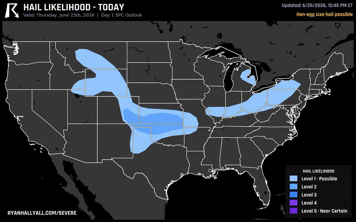
Hen-egg-size hail, 2 inches and up, is the early threat with the storms going up across the southern Plains today.
The best shot at it is around Anthony, Dodge City, and Kingman, Kansas. That's stones big enough to crack a windshield, so anything parked outside out there is worth tucking away. The strongest lone storms drop the worst of it before they clump together this evening.
You wanted more. We delivered.
🟡 FREE METAR Station Plots.
⭐ Storm Highlight + Draggable Popups (Plus).
⚡ And 15+ more improvements/additions.
Check out the graphic, then jump into the app and come back to tell us what you're lovin'!
Oh... and we're already working on the next update. 😉
📲 Find WeatherWise on the Apple App Store, Google Play, or use our web app (link in bio).
A Level 3 of 5 severe risk is up again today across Wyoming, Colorado, and Nebraska.
The big story is hail. Storms fire off the high ground this afternoon from southeast Wyoming into northeast Colorado, and the strong winds up high are lined up to build true supercells. We're talking stones 3 to 4 inches across, baseball size and bigger. A quick tornado or two is on the table, and once these clump into a line later they can throw down damaging gusts.
If your car's out in the open out there, get it covered before this afternoon.
A Level 2 of 5 severe risk covers two very different setups today.
Out on the High Plains in northeast Colorado, storms fire off the high ground this afternoon on their own, and that's where the very large hail comes. A tornado or two is possible there too.
The bigger area runs across Virginia and North Carolina. Storms roll off the mountains this afternoon and push toward the coast, with damaging wind the main worry. Beyond that, near the warm front up around DC and Baltimore we flagged yesterday, a couple of quick tornadoes are still possible.