If ancient civilizations built the Seven Wonders thousands of years ago with primitive tools, why does modern civilization struggle to create monuments that inspire the same awe today?
Bronze and crystal sword from China, dated to 450–250 BCE. Its handle was crafted from rock crystal, turquoise, and gold, while the bronze blade has developed a naturally formed greenish-blue patina over centuries of aging.
🚨 Graham Hancock talks about Mind-blowing Great Pyramid engineering puzzle:
"Above the king's chamber... are five further chambers... roofed and floored with granite beams that weigh about 70 tons each... hundreds of them." 😱
Context hits hard: "A 70 ton beam is equivalent in weight to 35 large SUVs."
Elevated insanely high: "These 70-ton Granite beams... have been elevated to a height of more than 350 feet above the ground and carefully and precisely placed."
The physics problem: "It is very hard for archaeologists to explain how that was done using purely leverage and mechanical advantage... You can't haul a stone weighing tens of tons up a slope that exceeds 10 degrees."
Ancient Egyptians defying basic ramp physics with massive granite? Lost tech, advanced methods, or something mainstream archaeology can't explain?
What do YOU think—how DID they lift and place those 70-ton beams so precisely? Aliens, forgotten machines, or just underrated ancient genius? What's your favorite pyramid mystery? Drop theories below! 🏛️🪨🔍
#AncientMystery #GreatPyramid
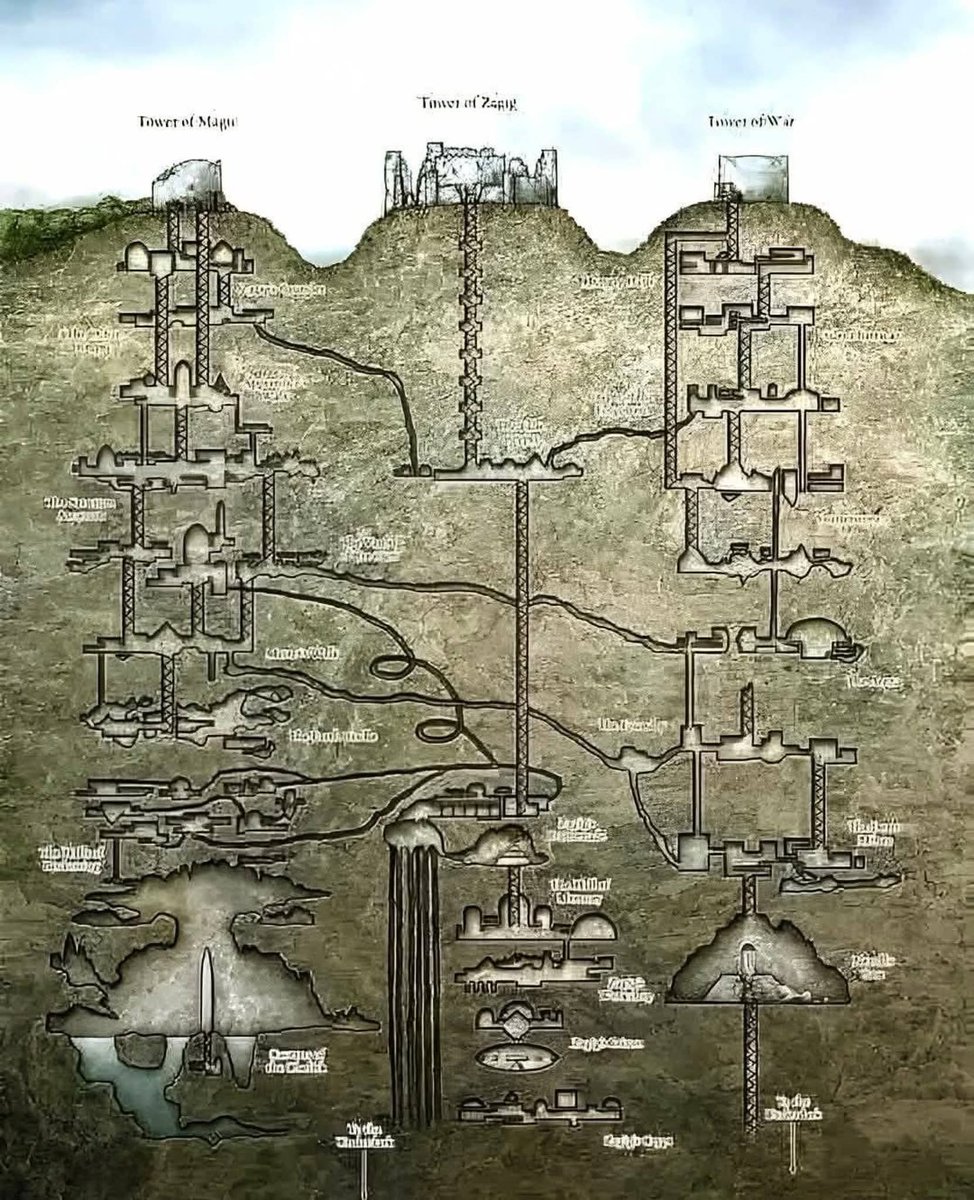
The diagram illustrates the astonishing vertical layout of Derinkuyu Underground City, the deepest known subterranean settlement in the world. First expanded around the 8th–7th centuries BCE (with later Byzantine modifications), Derinkuyu descends over 60 meters and contains 18+ levels carved directly into volcanic tuff. The cutaway reveals an advanced urban system: living quarters, kitchens, wineries, stables, chapels, schools, storage rooms, and massive circular stone doors that could seal corridors from invaders.
A central ventilation shaft—also serving as a well—supplied fresh air and water to every level, while narrow passages and elevation changes enhanced defense. This was not a cave, but a fully planned underground city capable of sheltering thousands for extended periods, demonstrating sophisticated engineering, ventilation science, and crisis architecture long before modern bunkers.
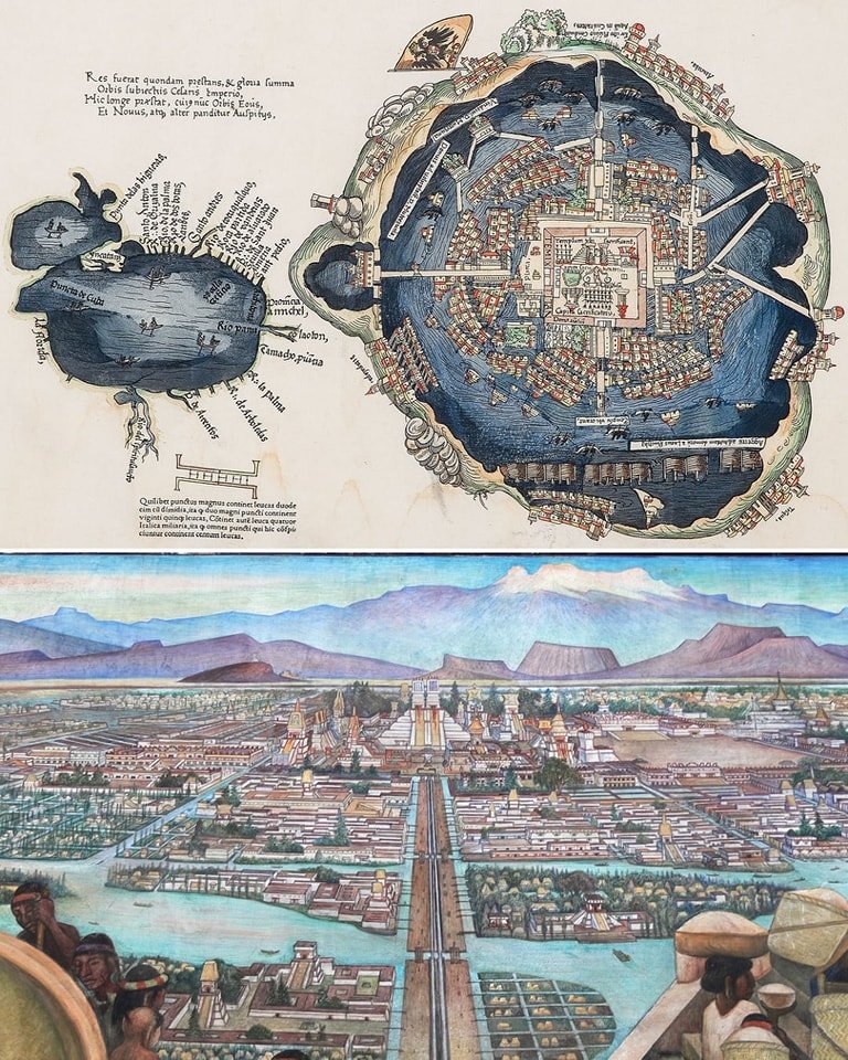
The 1524 AD, map of Tenochtitlan, published in Europe, a significant depiction of the Aztec capital, likely based on the sketches by Hernán Cortés and indigenous sources. This map, appearing in Venice and Nuremberg, showcases the city's layout, including its temples, palaces, canals, and causeways, while also referencing Aztec practices like human sacrifice...
The map of Tenochtitlan, published in 1524 AD, one of the earliest European visual representations of the Aztec capital. It was included in a letter written by Hernán Cortés to the Holy Roman Emperor, Charles V, and gave Europeans their first glimpse of the magnificent city. The map depicts a city of remarkable urban planning, built on an island in the middle of Lake Texcoco and connected to the mainland by causeways. It shows the city's grid-like layout, its temples, and the central ceremonial precinct, providing a visual testament to the awe-inspiring sophistication that Cortés and his men described.
In stark contrast, Diego Rivera's 1945 mural, "The Great City of Tenochtitlan," offers a vibrant, indigenous perspective of the same city before the Spanish conquest. As part of his larger work "Epic of the Mexican People" at the National Palace in Mexico City, Rivera's mural is a powerful piece of historical and political art. It depicts Tenochtitlan as a bustling, thriving metropolis filled with market scenes, agricultural activities, and a flourishing cultural and religious life. Rivera's work aims to reclaim the pre-Hispanic history of Mexico, portraying the Aztec capital not just as a marvel of engineering, but as the heart of a complex and rich civilization that was tragically destroyed.
Together, the 1524 map and the 1945 mural provide two distinct yet complementary views of Tenochtitlan. The map, while a tool of a conqueror, highlights the city's impressive structure and organization. The mural, created centuries later by a Mexican artist, celebrates the life, culture, and power of the civilization that built it. Both works underscore the scale of the city that left the Spanish so astounded they questioned if they were "dreaming."
#archaeohistories
2,000-year-old frescoes in the Room of the Frescoes in the Villa dei Misteri, Pompeii. Buried by the eruption of Mount Vesuvius in 79 AD, it was rediscovered in 1909.
Using this aerial photo to deny the incredible precision of the Giza Pyramids is disingenuous 💯
- They were significantly quarried for centuries
- They endured countless earthquakes over 5 millennia, including one so massive it knocked the casing stones off
Precision engineering is there for all who have eyes to see 💥