🧵 El verano de 2026 (junio-julio) es el más cálido de la serie histórica en España, que arranca en 1961.
➡️ Con una temperatura media de 24,5 ºC, supera en 0,7 ºC a los bimestres junio-julio más cálidos, los de 2022 y 2025. Es 2,9 ºC más cálido que el promedio 1991-2020.
🦺🚨A Wetter-than-Normal Autumn Could Materialize Across Southwestern Europe,2026.
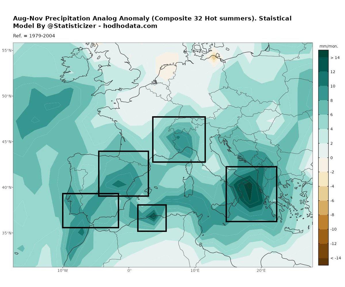
The map below presents my August–November precipitation analog composite, developed using a statistical analog approach based on late spring and summer thermal gradients for SW Europe In particular . In this methodology, exceptionally warm May–July periods are used as analogs to estimate the subsequent autumn precipitation patterns across Southwestern Europe, the Mediterranean Basin, and parts of the United Kingdom. The yielded findings converge on other prior forecasts and on early Numerical weather predictions models forecasts (GFS, ECWMF) .
Therefore, this analysis is not based on a Super El Niño composite. While some Super El Niño years (from the historical archive spanning 1640–2006) may be included among the selected analogs, they are incorporated solely because they share similar large-scale atmospheric and oceanic structures—not because they are Super El Niño events. Just as no two individuals are identical, no two El Niño episodes produce exactly the same rainfall distribution . However, the historical record does contain seasons with remarkably similar large-scale climatic structures, and these structural analogs form the foundation of this forecasting methodology.
The composite analysis consistently points toward a wetter-than-average autumn across large portions of the #Iberian_Peninsula 🇪🇸🇵🇹, Southern UK 🇬🇧 , southeastern #France 🇫🇷, northwestern and southern #Italy 🇮🇹, Greece 🇬🇷, and neighboring Balkan regions.
Although rainfall distribution is expected to vary from month to month, the wettest phase is most likely between September and early November, with October currently emerging as the month exhibiting the strongest signal for above-normal precipitation.
The dark green shaded regions highlight areas with the highest statistical likelihood of above-normal precipitation, increasing the potential for flash flooding, river flooding, and torrential rainfall events during the season. Based on the composite analysis, the areas of greatest concern include:
The #Ionian and #Adriatic Seas and their surrounding coastlines
Southeastern France
Northwestern Italy
Eastern Spain and the border regions with southern France
Southern UK
Parts of North Africa.
As with all long-range seasonal outlooks, these maps represent probabilistic climate anomalies rather than deterministic weather forecasts. They identify regions with an elevated likelihood of wetter-than-normal conditions, while the timing, location, and intensity of individual weather events will continue to depend on shorter-term atmospheric developments.
Methodology: Statistical analog forecasting, composite analysis, multivariate climate pattern matching, and artificial intelligence-based pattern recognition.
If you find this analysis useful, please consider sharing♻️ it and subscribing for future updates.
Early warnings save lives, reduce economic losses, and help communities prepare for high-impact weather events.
Prior later summer and early autumn forecasts:
https://t.co/CBzDpIjC0r
https://t.co/Lk8BokuK0J
Prepared by:
Mr. Mohammad Alkhateeb ( @Statisticizer )
The Chief Data scientist at Hodhod Data – Statistical Research & Long-Range Forecasting
https://t.co/4PftHqD0mL
🚨#HeadsUp How likely is Western Europe to experience another early spring heat dome in 2027?
This is an interim probabilistic outlook covering approximately the next 10 months (August 2026–June 2027).
The forecast is based on 20 candidate analog years, selected according to the current evolution of oceanic, atmospheric, ocean–atmosphere coupling, astronomical, and calendar-related (calendricity) factors. The analog ensemble suggests that the ongoing El Niño event may gradually weaken between December 2026 and April 2027, before showing signs of strengthening thereafter.
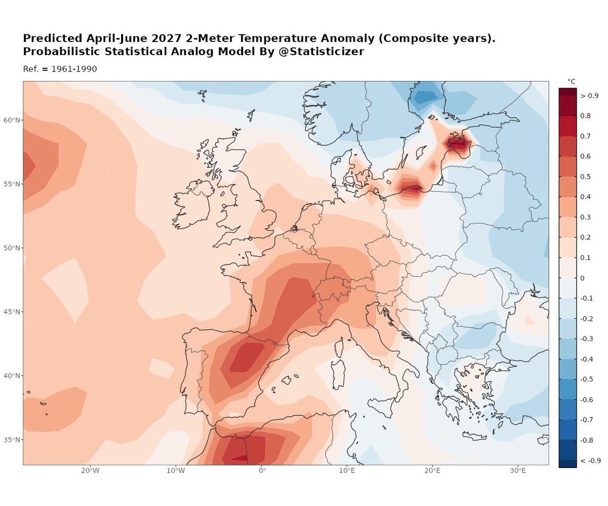
The resulting composite of 2-meter air temperature anomalies indicates that an early spring heat #dome, similar to the one we've experienced this year, could re-emerge during spring #2027, with the strongest signal extending from April into June, followed by gradual weakening toward late May and early summer .
In the attached map, the composite is based on 27 analogue seasons out of 34 examined, with red shades indicating a tendency toward warmer-than-normal conditions during April–June .
🩲Bottom line
Based on this empirical analog approach, there appears to be a modest to moderately high probability that southwestern Europe and parts of western Europe could once again experience an unusually warm spring, potentially leading to an early-season heat surge during April–June #2027.
Double-Dipped and Triple-Dipped Hot Spring and Summer seasons do exist , indeed , in the climatic archive of Europe , going back to 400 years ago .
📊 Historical analogs indicate that successive warm springs and hot summers have occurred repeatedly between 1640 and 2026, although not in every case. Within my analogue database, I identified at least 32 candidate seasons in which warm spring and summer conditions persisted for two consecutive years , and in some instances three consecutive years, albeit with differences in the geographical distribution of the heat anomalies. Overall, back-to-back hot summers appear to have occurred more frequently than consecutive hot springs.
As with any long-range probabilistic forecast for Spring season 2027 , this outlook should be interpreted as an assessment of risk rather than a deterministic prediction.
🔄 This outlook is preliminary and should be taken with a grain-of-salt for now. The forecast will be updated in December 2026 as new atmospheric, oceanic, and solar observations become available, allowing the signal to be reassessed in the model and either strengthened or revised.
Kindly share ♻️♻️ the outlooks. Early warnings save lives and protect property!
__
Climatic downscaling and Statistical Modelling by the chief data scientist " Mr. M. " @ https://t.co/4PftHqD0mL .
@Statisticizer
Buenos días, el incendio de Orés sigue evolucionando favorablemente pero mientras todo el país celebraba con la selección reconozcamos a los héroes que siguen luchando en el #ifLaMierla
Imagen izquierda nuevos focos de esta noche, derecha todos los focos desde el comienzo del 🔥
A la espera del nuevo informe de la emergencia anunciado por Copernicus para esta tarde, el sensor de detección de incendios de la NASA en la última pasada muestra las áreas más activas al O y SO lo que guarda relación con el viento de N y NE que ha soplado esta noche #IFOrés
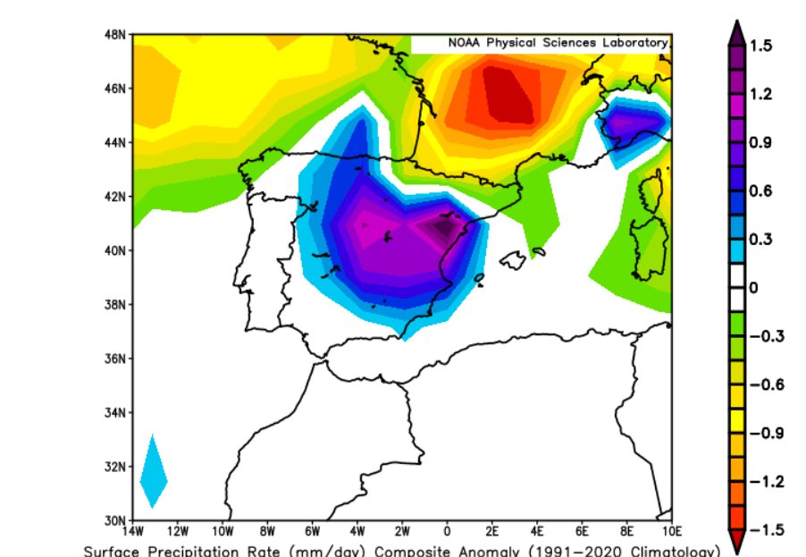
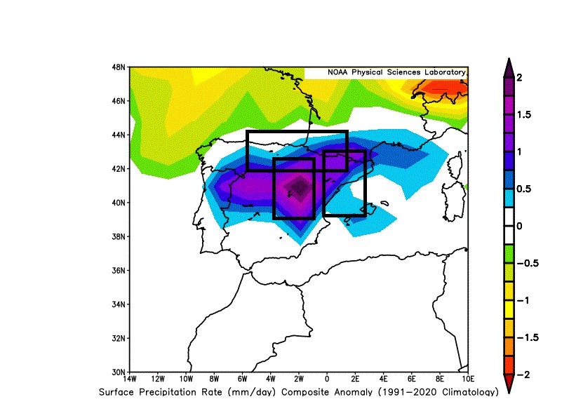
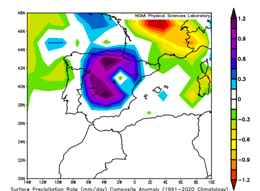
🚨There is tentative agreement between the European ECMWF and the American GFS numerical weather prediction models that the last week of July may become wetter than normal across many parts of Iberia.
My analog analysis suggests that rainfall could become even more widespread and intense than is currently depicted by the numerical models. In the maps, purple shading indicates the highest rainfall anomalies, while blue-shaded areas and the regions enclosed by black boxes represent hotspots where recurrent episodes of heavy to torrential rainfall may develop from late July into August. The deeper the purple anomaly, the greater the probability of above-normal rainfall.
The regions within black boxes are predicted for recurrent rainfall and or torrential rainfall events during August in Particular, according to the statistical analog analysis.
This outlook remains probabilistic and preliminary. However, if the analog pattern continues to verify, I expect the numerical weather prediction models to gradually strengthen the rainfall signal over the coming days, bringing their forecasts into closer agreement with the analog guidance ( hopefully) .
🇪🇸🇵🇹 Pronóstico especial para mis amigos de España y Portugal
Con mucho cariño para mis amigos de España y Portugal, les comparto este análisis estadístico basado en técnicas de modelización por análogos atmosféricos.
Para agosto, el modelo sugiere una mayor probabilidad de precipitaciones por encima de lo normal en amplias zonas del norte y noroeste de la Península Ibérica, especialmente en Galicia, el norte de Portugal y la costa cantábrica. Los tonos verdes más intensos del mapa indican una mayor propensión a lluvias superiores a la media climática.
En el resto de la Península Ibérica y el norte de África, las anomalías previstas son más débiles, por lo que se esperan condiciones cercanas a la media, aunque con la posibilidad de episodios aislados de lluvia asociados al paso de sistemas atlánticos. Si este patrón atmosférico se confirma, el riesgo de tormentas localmente intensas y lluvias abundantes será mayor en el noroeste de la Península, mientras que el resto de las regiones mantendría un comportamiento más variable.
Como siempre, este mapa representa un pronóstico estadístico probabilístico de las anomalías medias del mes y no debe interpretarse como una predicción determinista del tiempo diario.
Un cordial saludo desde Jordania.
Mr. M. (@Statisticizer)
🌐 https://t.co/4PftHqD0mL
Seguimos con gran preocupación el incendio declarado hoy en las altas Cinco Villas en Orés y que ha obligado al desalojo preventivo de varias poblaciones
Mucho ánimo
🌍 🚨August–September 2026 Analog Synoptic and Weather Outlook
🩲Brief summary :
Based on 41 statistical analog years (1638–2026) selected using Artificial Neural Networks (ANN), Latent Factor Analysis and Entropy-based modelling, the large-scale atmospheric pattern continues to favor a more unsettled and wetter late summer into early autumn across parts of southern and central Europe, while relatively warmer and drier conditions are more likely toward northeastern Europe.
The composite circulation is characterized by below-normal MSLP and 500-hPa geopotential heights extending from the eastern Atlantic into western, central and parts of southern Europe, supporting more frequent Atlantic troughs and frontal passages. At the same time, cooler-than-average 2-m temperatures are projected across much of central Europe, the Balkans, northern Italy and parts of Iberia, consistent with enhanced cloud cover and recurring rainfall episodes rather than persistent heat.
🌧️ Regions with an elevated risk of above-normal rainfall and occasional flooding include:
🇫🇷🇨🇭 Eastern France, Switzerland and the Alpine region – strongest positive rainfall anomalies in the composite, increasing the likelihood of repeated heavy rainfall episodes and localized flash flooding.
🇩🇪🇦🇹🇨🇿 Southern Germany, Austria and Czechia – enhanced Atlantic disturbances may bring frequent rainfall and periods of hydrological stress.
🇵🇱🇸🇰🇭🇺🇷🇴 Poland, Slovakia, Hungary and Romania, extending into 🇺🇦 western Ukraine, show a broad wet signal that could support multiple heavy-rain events.
🇮🇹 Northern and central Italy, especially the Alpine foothills, Po Valley and parts of the northern Apennines, display a consistent positive precipitation anomaly with cooler temperatures, suggesting a more unsettled late summer than average.
🇪🇸🇵🇹 Northern and eastern Spain, together with parts of Portugal, also lean wetter than normal. While the signal is weaker than over the Alps, repeated Atlantic lows and locally intense convective storms could produce episodes of heavy rainfall and flash flooding, particularly in northern Iberia and mountainous terrain.
🇸🇮🇭🇷🇧🇦🇷🇸 Slovenia, Croatia, Bosnia & Herzegovina and Serbia may also experience recurrent thunderstorm activity and locally heavy rainfall.
From a teleconnection perspective, the analog composites broadly resemble a combination of:
➕ SCAND (Scandinavian Pattern), helping maintain higher pressure over northern Europe Vs. N. Italy .
➕ North Sea–Caspian Pattern (NCP), supporting troughing over western and central Europe.
➕ East Atlantic–West Russia (EA/WR) configuration, reinforcing cooler and more unsettled conditions across parts of central Europe.
Near-neutral to slightly positive NAO, allowing Atlantic systems to continue affecting Europe without a persistent blocking regime over Southern and Western Europe .
As always, these are probabilistic seasonal outlooks, intended to highlight the most likely large-scale atmospheric tendencies rather than the timing of individual storms. Deterministic weather forecasts issued closer to each event remain essential for local forecasting.
In general, a wet to very wet autumn awaits southern Europe and Mediterranean as well as #Iberia and North African regions this coming autumn season-2026. This rainy signal pattern may start earlier in late summer.
🚨If you live in or have family in the highlighted regions, please share♻️♻️ official weather warnings and early alerts whenever severe weather threatens. Timely information helps protect lives, property and communities.
Thank you for your continued support, for sharing these outlooks, and for following the updates.
Statistical modelling & climatic downscaling By:
The chief data scientist Mr M. (@Statisticizer)
🌐 https://t.co/4PftHqD0mL
__
#EuropeWeather #SeasonalForecast #Climate #FloodRisk #HeavyRain #Storms #Meteorology #SynopticMeteorology #LongRangeForecast #AnalogForecast #WeatherResearch #EarlyWarning #DisasterRiskReduction #Hodhodata #Statisticizer
@globerourdiales Voy a tirar a hacer tesis doctoral sobre cambio climático, intentaré mezclar tema de meteo, riesgos naturales, estratigrafía, ciclos de milankovitch, etc.
Tiempo al tiempo (nunca mejor dicho)
Ya iré contando
‘A KNIGHT OF THE SEVEN KINGDOMS’ has been nominated for 9 Emmys.
• Best Drama Series
• Best Cinematography
• Best Sci-Fi/Fantasy Costumes
• Best Production Design
• Best Sci-Fi/Fantast Hairstyling
• Best Music Composition
• Best Sound Editing
• Best Special Visual Effects
• Best Stunt Performance