LOWELL IMPACTS 🌀: FOX Weather Storm Specialist Mike Seidel was about to go live on air when a powerful wave swept through, nearly knocking him and the camera operator to the ground. Mike will be live from Kaua'i, Hawaii throughout the day covering the impacts of powerful Hurricane Lowell. Stick with FOX Weather for all the latest.
FLORIDA LABOR DAY WEEKEND! 🥵🌦️
Hot, humid with more scattered storms. Extra humidity will make it feel like 105 - 110. If you'll be heading to the beach or pool to cool off, be on the lookout for storms. Have a great holiday weekend!
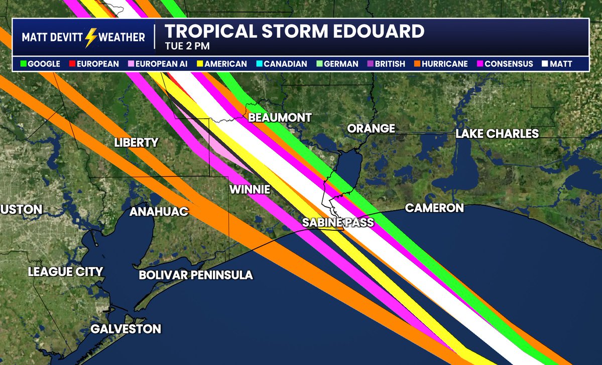
NEW: 00z models (most recent) are in for the landfall of Tropical Storm #Edouard on Tuesday. My model takes it pretty much right into Sabine Pass and the TX/LA border. Google is green.
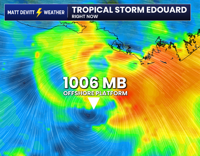
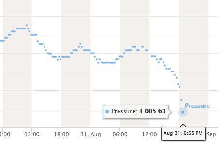
Tropical Storm #Edouard appears to be strengthening. NHC reported a pressure of 1010 mb at 8 PM ET and an hour later an offshore platform close to the center is reporting 1006 mb and falling. Wind is also sustained at 47 mph and gusting to 58 mph (elevated, height near 100 ft). More: https://t.co/V7OH838Dzb
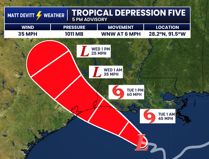
NEW ADVISORY: Remains a Tropical Depression as of 5 PM, but peak strength was increased from 45 mph to 60 mph before landfall Tuesday.
Storm Surge Watch issued for High Island, Texas, to the Vermilion/Cameron Parish Line, Louisiana. Surge forecast increased to 2 - 4 feet. #Edouard
NEW: Tropical Storm Warning is in effect for Southeastern Texas into Southwestern Louisiana, specifically Port Bolivar to the Vermilion/Cameron Parish Line shown below (blue). #Edouard
#BREAKING: First cone is out for Potential Tropical System #5. Tropical Storm Warning issued for parts of the Upper Texas Coast and Southwestern Louisiana Coast. #Edouard
Tropical Storm Watches and/or warnings will likely be issued for the southwestern Louisiana and Upper Texas coasts later today for the small area of low pressure in the northwestern Gulf.
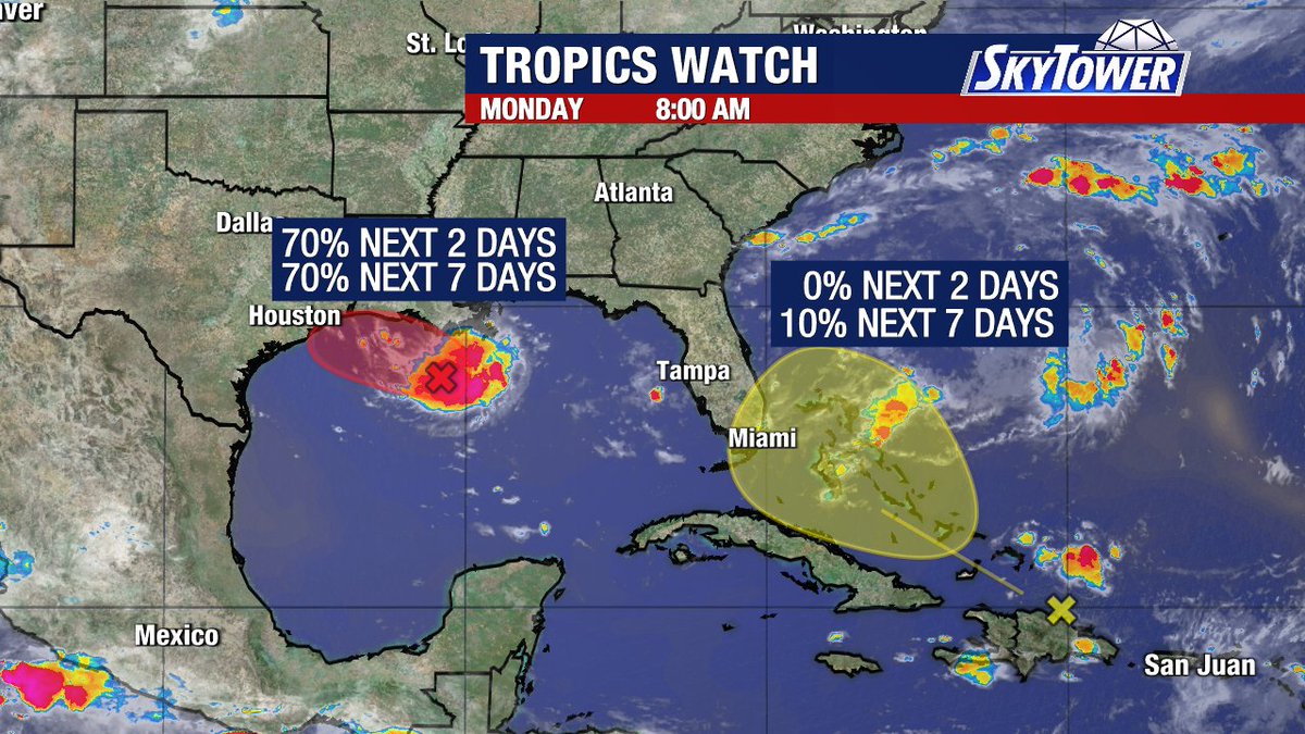
Meanwhile, the remnants of Tropical Storm Dolly are producing showers and thunderstorms from Hispaniola eastward to the northern Leeward Islands. This system continues to encounter unfavorable upper level winds as it moves quickly to the west northwest at 20-25 mph. Not expecting significant local impacts from this system except for enhanced rainfall as the moisture heads our way later this week. #Skytower
#BREAKING: Potential Tropical System #5 has been designated in the Gulf. Its first cone along with tropical weather alerts will be coming at the top of the hour. More to come…#Edouard
NEW: NHC increases chances to 70% now for Invest #97L to become a short-lived Tropical Depression or Tropical Storm #Edouard briefly in the Gulf. Could have a cone as early as tonight into Monday. I'll keep you posted.
FLORIDA SUNSET! 🌅⚡️ Check the colorful and electric scene this evening along Duval Street in Key West. What a shot! Have a great weekend everyone. Credit: Kristen McNamara @stormhour
TROPICAL UPDATE: New models out for the remnants of #Dolly. I know the lines can initially appear ominous, but we need to put things into perspective first. These are tracks for the leftovers of Dolly, which includes extra tropical moisture and additional rain chances for the area it heads toward. Florida still needs the rain! I still can't rule out tropical development, the NHC has slightly bumped up those odds to 20%. I'll keep you posted regardless.