🎉#LatestPaper
A Multifaceted Approach to #Developing an Australian National #Map of Protected #Cropping Structures
✍ by Andrew Clark, Craig Shephard, Andrew Robson, Joel McKechnie, R. Blake Morrison and Abbie Rankin @unetweets
👉https://t.co/7KPNkkWCO3
#greenhouses#satellite
@richc117 @SamA_Btown @Esri@gischatbot@richc117 Yes, I edit (alot) using the attribute editor. When I select multiple features in the map, I need the editor to assume I'll be making edits to all features selected. Shouldn't have to click the top of the tree to apply to all... a click saved is another edit made 👌
AARSC starts its search for nuts in South Africa🌍🛰
Crop mapping technologies by @UniNewEngland's AARSC research team sought internationally https://t.co/4quTXN4uji
#research#remotesensing#biosecurity
New year, new job?!
We're hiring a Spatial Analyst based in Brisbane!
For all the details and how to apply see here: https://t.co/R4Zy8MRmmW (Reference Number 222005)
Using the Australia Tree Crop Map: Severe Weather App two storm cells were detected over Lewiston, SA yesterday. https://t.co/sDFQaZNVuY
The first at 9:14am and again at 10:49am.
The potential impacts area for olive groves was 555ha and 355ha.
@Hort_Au#AustralianOlives
NSW stats have been updated in the Australian Tree Crop Dashboard:
🥑 Avocado Orchards 2,270 ha
🍌 Banana Plantations 880 ha
🍊 Citrus Orchards 16,325 ha
🌰 Macadamia Orchards 15,058 ha
🥭 Mango Orchards 171 ha
🍸 Olive Groves 5,507 ha
Something missing? https://t.co/NDVMhJJl2X
We are Spatially Enabling the Nation’s Protected Cropping Industries 🛰💪
New project announcement! https://t.co/oGS91Tgtx6
Lead by our team at AARSC with the support of @Hort_Au@FutureFoodCRC@UniNewEngland@llsnsw and Protective Cropping Australia
#remotesensing#research
🌏 AARSC put *on the map* with *FIRST PLACE* in global conference.
🏆 Congratulations to our very own @joel_mckechnie and @megdog77 who have been awarded FIRST PLACE at the global Esri User Conference for their Australian Tree Crop Map Dashboard: https://t.co/XpBFjO8GU6
🌰Pictured is the potential impact zone of a storm cell (oval shape) to 943ha of macadamia! #thatsnuts
⛈Captured via our Australian Tree Crop Severe Weather App, one of yesterdays many storm cells racing across QLD.
Track storm cells past and present https://t.co/xZGzr86xFZ
South Australia’s stats from the Australian Tree Crop Dashboard (as of 06/05/2021)
🥑 Avocado Orchards 327 ha
🍌 Banana Plantations 0 ha
🍊 Citrus Orchards 6,559 ha
🌰 Macadamia Orchards 0 ha
🥭 Mango Orchards 4 ha
🍸 Olive Groves 6,020 ha
Discover more https://t.co/b9BfYoUgTp
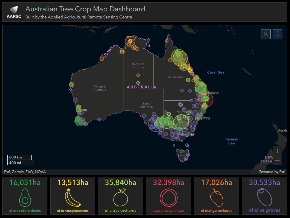
Horticulture tree crops... how much and where??? Launch and interact with the Australian Tree Crop Map in our Dashboard app and find out! For the best experience we recommend viewing on your desktop. @EsriAgriculture @ArcGISApps@esriaustralia#GIS
Exciting #PhD#scholarships for Aus students on #remotesensing and field sensors (dendrometers, sap flow, soil moisture, weather) in tree crops for irrigation, stress, yield, mapping with @une_aarsc https://t.co/wr9Y2kubfq
@esriaustralia@EMSINAGroup Thankful for great work of EMSINA to create the national burnt area feature service layer. A map (updated in near-real-time) of potential impact critical to response and recovery. Well done.