INCREDIBLE: A Saildrone penetrated the eye of Hurricane #Isaias on Friday, measuring wind gusts topping 100 mph and waves over 30 feet!
Video credit: Saildrone & NOAA
Hurricane Nolo has become Typhoon Nolo...
As Nolo reaches the 3-week mark since it first formed, it has become one of the few tropical cyclones to form in the Eastern Pacific and make the journey into the Western Pacific.
After crossing the International Date Line, Nolo is now referred to as a typhoon rather than a hurricane. “Hurricane” and “typhoon” describe the same type of tropical cyclone, just that the terminology simply changes depending on which region of the world the storm is in.
Nolo is also the first storm since Genevieve in 2014 to cross from the Central Pacific into the Western Pacific while at major-hurricane strength.
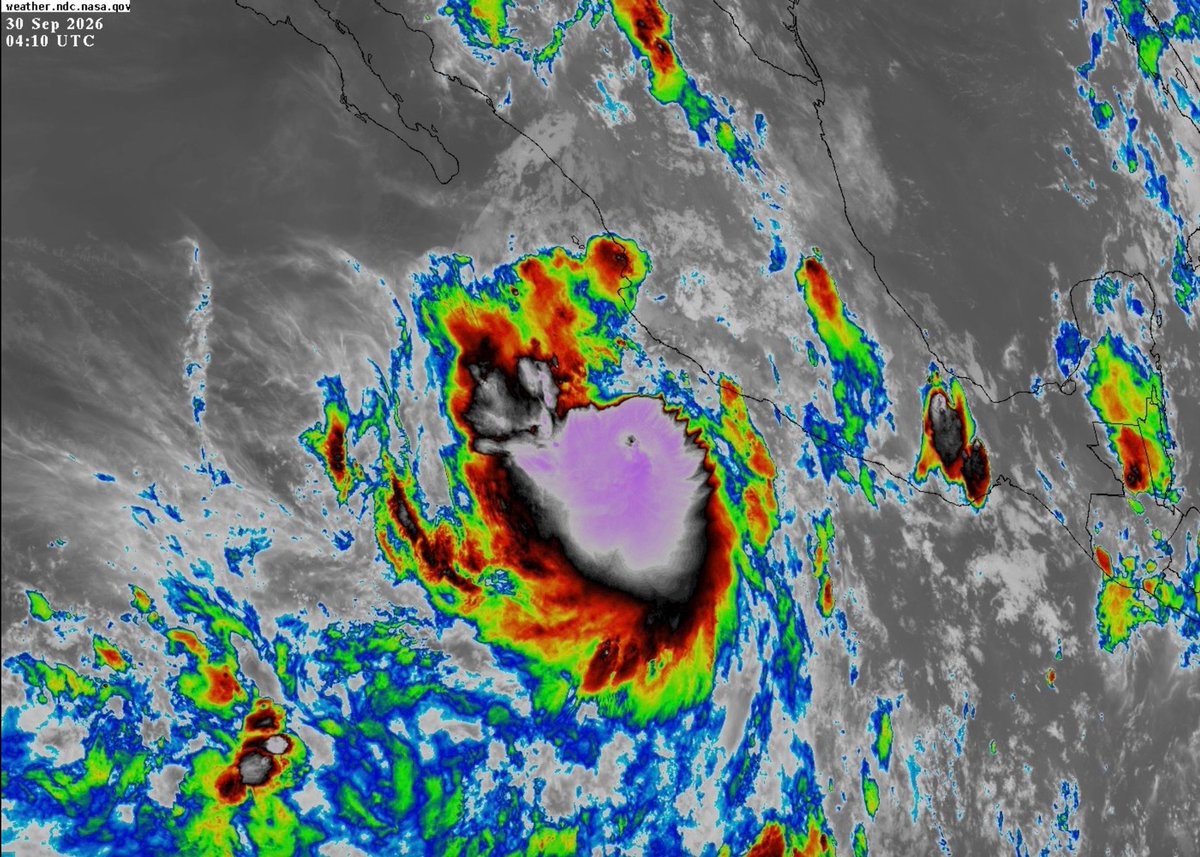
This is not a satellite image of Polo last week. This is yet ANOTHER storm just off the coast of Mexico, intensifying right now as we speak.
While she is no threat to land, Tropical Storm Rachel here has consistently been consumed in incredibly deep, icy convection today. Some of the coldest you’ll see for an East Pacific storm.
With such a glacial overflow of thunderstorms so early in her life cycle, the only thing that is going to restrain this storm is the fact that she is tracking through almost the exact same path Hurricane Polo just took, where upwelled ocean waters have been considerably cooled.
THIS IS WILD! Hurricane Nolo has the "stadium effect" and mesovortices, and is nearly a Category 5 Hurricane about 350 miles Southwest of Hawaii...
@WxFront
It’s very rare for a Hurricane to reach 180 MPH winds at all. It’s almost unheard of for one to reach it TWICE.
That’s what Hurricane Polo just did today. Two distinct, completely separate 180 MPH peak intensity phases during completely different stages of the cyclonic life cycle.
What we’re seeing take place near Mexico’s Pacific coast this week is nothing short of the meteorologically exceptional.
The MOST INTENSE storm pressures ever recorded in Earth’s Western Hemisphere:
🇲🇽 872 mb in Hurricane Patricia
🇲🇽🇺🇸 882 mb in Hurricane Wilma
🇯🇲🇲🇽 888 mb in Hurricane Gilbert
🇯🇲🇨🇺 892 mb in Hurricane Melissa
🇺🇸 892 mb in the Labor Day Hurricane
🇲🇽 892 mb in Hurricane Polo
The 2026 Atlantic hurricane season has the lowest accumulated cyclone energy to date...
While we have seen 5 named tropical storms this year, all of them have been weak and short-lived, with 0 storms reaching hurricane strength. This leads to why Accumulated Cyclone Energy (ACE) matters: ACE is a metric used by meteorologists to measure the total wind energy output of a season by factoring in both the maximum intensity and the duration of every named storm.
Because ACE is calculated by taking the square of a storm's maximum sustained winds every six hours, weak tropical storms that quickly dissipate barely make a dent in the overall seasonal total. Through September 8, the 2026 season has generated an incredibly low ACE of just 4.40, undercutting the previous record low of 4.80 by this point in 1984.
For context on just how historically dormant the Atlantic basin has been, the long-term average ACE through this exact date is 45.91.
DC Forecast
Sunday Forecast:
🌤️ Sunday Brightens Up in the DMV
Sunshine returns with highs in the mid 60s in DC, breezy conditions at times.
🌡️ Monday Warm-Up:
Temperatures climb into the mid 70s with a mainly dry day for most.
#DC#Virginia#DMV#Maryland#Weather#Forecast
Tomorrow begins Hurricane Preparedness Week. Stay tuned for daily posts on the best ways to get ready for #Hurricane Season. #HurricaneStrong#HurricanePrep https://t.co/fJwXQ0wTo5
From the 80s to FREEZING?
It's 30 to 40 degrees colder today (Sunday) than yesterday (Saturday).
The drop in temperatures is setting the stage for freezing temperatures in parts of the D.C. area Monday night into Tuesday morning.
The National Weather Service has issued a freeze watch for areas west of I-95 from 2 to 10 a.m. Tuesday for temperatures as low as 29 to 32 degrees. In some areas, this freeze is coming up to 10 days later than the typical last freeze. “Many areas are ahead of schedule from a growth stand point so this freeze could be rather impactful,” the Weather Service wrote in a discussion. Sensitive plants should be brought inside or covered, if possible.
Areas inside the Beltway and to the east will probably remain above freezing, but some scattered frost is possible, with lows in the mid- to upper 30s.
Posted 1035a Sunday
Super Typhoon Sinlaku is now a 175 MPH (280 kph), 902 MBAR CATEGORY 5 megastorm per the JTWC. She is officially the world’s most powerful cyclone of 2026.
Her scorching eye has carved out one of the sharpest and cleanest Stadium Effects I can ever recall, and her CDO is a superchilled whirlpool of the scariest storm conditions imaginable. We are witnessing meteorological insanity.
11-seed VCU shocks 6-seed UNC 😱
VCU head coach Phil Martelli Jr. joins SportsCenter after his Rams pulled off a thriller in the first round of the NCAA tournament 🤩
Latest snowfall total projection from Kaitlyn McGrath @wusa9 !! Has definitely been a tricky forecasts with the GFS going bonkers with the projected totals. ONLY way that gets close to checking out is if this were an all snow event. Which it will most likely not be!
Late night model watchers-- it's kinda crazy, but we're less than 30 hours from the start of this storm and here are the projected snowfall totals for DC from the two models you hear most about:
European: 3-4 inches
American: 17-20 inches
(These numbers assume all snow sticks, but some will be lost to melting)
Agonizing forecast. We lean toward the Euro but stay tuned for updates Saturday.