Did you feel that earthquake near San Diego?
Plan ahead & prepare for aftershocks!
Visit https://t.co/8xWNbjcIcY for FREE resources in multiple languages to help you make a disaster ready plan.
Critical fire weather conditions continue across southern California through late Friday, but
a storm system will bring increasing coverage of rain and mountain snow for much of
central and southern California Saturday through Monday. Here is an update from @NWS
🔥 Critical Fire Weather Alert
Much of Southern California is facing critical fire weather beginning Monday at 10 a.m. and lasting through Tuesday at 10 p.m.
Strong winds and low humidities are expected to increase the risk of fire danger. One less spark means one less wildfire.
State, local, federal, and tribal resources - including assistance from out-of-state and international partners are still mobilized in the region and stand ready to respond to new initial attack fires.
Activate the “Red Flag” layer of the CAL FIRE incident page at https://t.co/672BA88S7T for the most up-to-date warning areas.
Stay prepared. Stay safe. For fire prevention tips and emergency planning, visit https://t.co/xAsi7kicHn.
#RedFlagWarning #CAwx
Moderate to locally strong Santa Ana winds return Monday-Thursday to parts of SoCal, meaning more PSPS de-energizations. Watch as @LACOFD Chief Anthony Marrone explains how these shutoffs are crucial to preventing new fire starts and helping save lives. https://t.co/BDUw4GFIQg
Our community needs us. Your time can make a life-changing impact — volunteer today: https://t.co/40C3dY0ASE 💙🧡
Let’s rebuild, heal, and support our neighbors. For resources, visit https://t.co/uazuzeIkzw.
More of the same incoming 🔁 Here is our latest prediction for peak Santa Ana wind gusts through tomorrow evening. Elevated to critical fire weather conditions expected for inland areas. There will be a brief lull Sunday night before the winds pick back up again Mon-Wed.
No major changes in today's forecast. Santa Ana winds will begin to return today and be with us well into next week. Nothing as bad as a few days ago, but conditions are exceptionally dry across the region and new fires will remain possible. Remain alert!
Recent @ReadyLACounty alert to evacuate was sent in ERROR. Evacuation orders have not changed. See map for actual @LACity evacuation orders for some selected areas, ONLY! https://t.co/qRYmG0qWS7
Critical fire-weather concerns will continue across the LA Basin and southern CA through Friday morning. Santa Ana winds will begin to tapper off midday Friday and into Saturday. Continue to take precautions and avoid activities that could start fires. See https://t.co/QMmU4tBZDt
Winds are finally letting up this morning but high fire danger still remains across SoCal! Winds will finally settle down tomorrow and we get a bit of a break through the weekend. Another potentially moderate #SantaAnaWind event is possible early next week so STAY ALERT!! #CAwx
In response to power outages, Central Park (11200 Base Line Rd.) is now open as a Windstorm Resource Center. You will be able to charge devices, access to free Wi-Fi, and bring small pets in carriers. Open Jan 8, 4:30 pm – Jan 9, 12 p.m. For more info https://t.co/zHyAACAW2X.
Particularly Dangerous Situation (PDS) Red Flag Warning is now in effect for Inland Orange County into parts of the N/W Inland Empire and foothills 🔥
Please see our quick update below and stay safe out there 🙏 #CAwx
Winds up to 80 mph and low humidity will continue to develop overnight into Wednesday morning. #SBCoFD has prepositioned strike teams, hand crews, and dozers in high risk areas.
✅ If you are asked to evacuate, please go immediately
✅ Sign up for emergency alerts
👉 https://t.co/fhWssz2mZq
✅ Create a #ReadySetGo plan
👉 https://t.co/ca6nAbxRig
Remain vigilant with any flammable or combustable materials. Any fire can spread rapidly in these conditions.
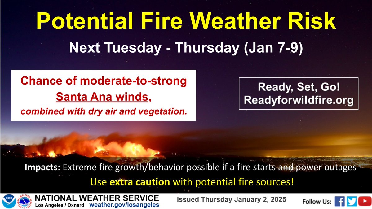
A strong Santa Ana event is still on tap for Tuesday through Thursday of this week. Another Santa Ana event may occur next weekend or early next week, but computer models show less of a chance today compared to previous days.
A strong Santa Ana wind event is possible beginning Tuesday next week. Still several days away so things may change, but a high end fire weather event is possible. If the forecast remains consistent with the way it looks now, SAWTi values will increase. Stay aware! #CAwx
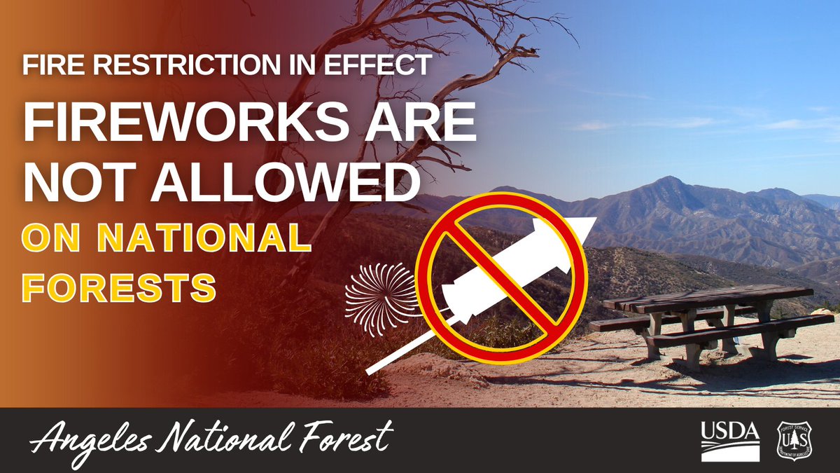
🚫Fireworks Prohibited in Angeles National Forest🚫
As New Year’s Eve approaches, remember: ALL fireworks are illegal in the forest, including sparklers and other pyrotechnics.
🔥EXTREME Fire Danger: The forest is at EXTREME fire danger, meaning conditions are highly conducive to wildfires. Fireworks are a leading cause of wildfires, and with dry conditions, the risk is too high to take chances.
Let’s ring in the New Year without risking lives, wildlife, and the beauty of our forest.
Elevated to critical fire weather conditions across portions of LA and Ventura Co due to the combination of gusty Santa Ana winds, very low humidities, and dry fuels. A Red Flag Warning has been issued for Santa Ana wind prone mtns, where winds are strongest. #firewx#cawx