#mplswx looking like our streak of days without snow cover is coming to an end. Models showing about an inch for metro starting around 3 pm Thursday. Worst possible timing for evening commute.
@NWSTwinCities how do I make it on the snowfall report map? I submitted it as an official report too but don’t see it. This has happened to me before several times with snow reports. I submit them, and they don’t show up.
@NWSTwinCities 5 inches through 11:15 AM at 817 Main St NE Minneapolis, MN 55413. I took several measurements due to drifting. All were between 4.5-5.5 inches.
Cold front is through Minneapolis. Just bought the Raddy N75 on Amazon. Great personal weather station. Only $45 and comes with app connectivity. I am going to also buy the more expensive version with a rain gauge and anemometer I like the temp/humidity version so much.
Wow I have never seen a worse poll in retrospect than the garbage the @DMRegister put out to stir up pro-Kamala headlines late last week. They were only off by 17%….
Well I make weather forecasts…. So might as well try an election one too. This is probably worst case scenario for Trump, and I expect him to still win pretty handily. I don’t see how Kamala can beat him when Hilary was a far stronger candidate and lost in 2016. #Election2024
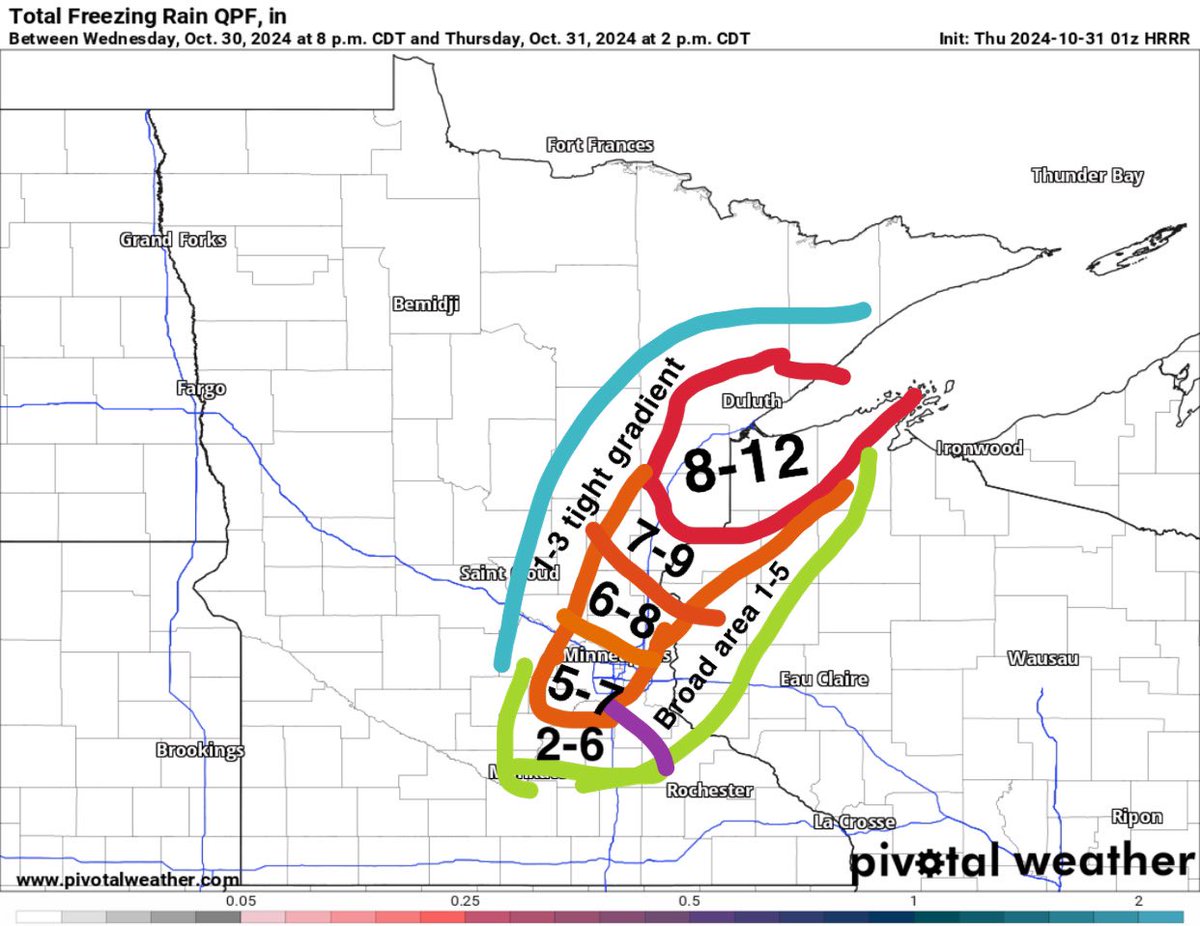
Sometimes my forecasts do ok… temps a bit too warm for the totals to come to reality at the ground but I bet that much snow will “fall” before melting.
Created my first ever personal snowfall forecast for today’s event after the 10/31 0z models came out last night. Maybe would move my graphic 25 miles west if I had to redo it now.
Now basing my forecast off 10:1 vs. Kuchera. I expect Kuchera is wrong and snowfall ratios will be >10:1. Very rare to see lower than 10:1, and if there is a sharp rain/snow transition, like I expect for tomorrow, you will see 20:1+ liquid to snow ratios right along it.
A MAJOR early season snowstorm is going to impact the MSP metro tomorrow morning for the Halloween commute.
NAM snow totals are trending up big time. The NAM is year over year the best winter wx model for MN. The HRRR is also showing remarkable run to run consistency for a convection allowing severe wx model attempting to forecast snow.
Tomorrow’s snow will be convective in nature. Thunder snow is possible⚡️❄️
I expect 2-4 inches for the metro. Local totals above 6 inches possible. Full whiteout from 7-9 AM. A high of 40 should melt most snow by trick or treating time.
Latest model runs, snow totals for Nov 1st
NAM, snow total history for Nov 1st
HRRR, snow total history for Nov 1st
#mn #mnwx #winterwx #msp #mpls #minneapolis #snow #halloweenblizzard
#mnwx#minnesota#mn#msp History doesn't repeat but it rhymes... back to back years with potential Halloween snow. Could be a rough AM commute on Thursday. Models seem to be trending towards a stronger low pressure solution. Honestly... do not know much about dynamic cooling, FGEN snow, winter cyclogenesis, etc. I DO know how to interpret NBMs and this event is trending up. I expect some white ground for MPLS on Halloween AM.
I was down on Lake and Hiawatha when it was happening, I am aware. I place the blame squarely on Walz, as once the National Guard finally showed up, the looting died down. Frey is not in control over the National Guard. He should not have to ask Walz to call it in. That is part of being the governor of a state, you are the commander in chief. I question his leadership if he felt the need to wait for Frey’s approval to send in the guard as Governor of MN.
And before 1543, 100% of scientists thought the solar system revolved around the earth. There’s a reason “appeal to authority” is listed as a rhetorical fallacy. It provides no logical reinforcement other than credentials us sheep are supposed to just take at face value.
@CrimeWatchMpls That explains why my car insurance is $290 a month for comprehensive, with a $1000 deductible, no accidents, and one speeding ticket going 65 in a 55 in 2020. My car insurance is more than my car payment, and I financed $13k of my car over 60 months at 8%. Thanks Walz.
@Zarhle1 This is the composite hodograph of 74 tornadoes in SE South America. Assume that means you can just mirror the southern hemisphere version over the x axis to see the northern hemisphere equivalent.
Unprecedented radar images out of SE Florida… I have never seen a long track tornadic supercell with such ridiculous low level shear in my life #Milton#MiltonFlorida#severewx