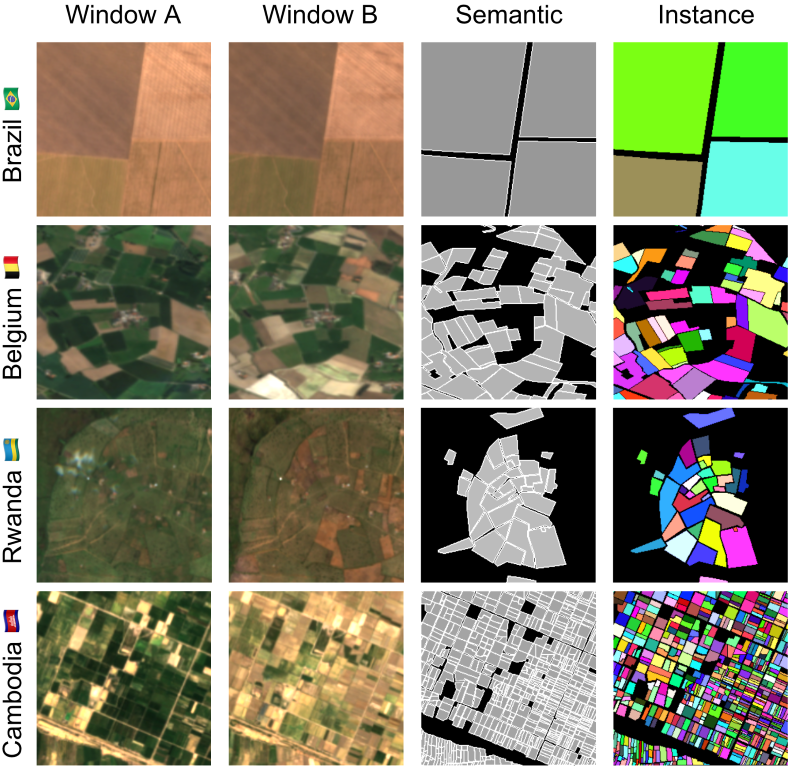
I'm so excited to finally introduce Fields of The World (FTW!) - the largest & most diverse ML dataset for field instance segmentation in satellite images. FTW has >70k samples from 24 countries (4 continents), with semantic & instance labels + Sentinel-2 RGB-NIR from 2 dates. 🧵
Thanks @EarthVisionWS for the recognition, especially after a couple of rounds of rejections at other venues!
Congrats to the team: Aayush (https://t.co/WKp6LaIdRf), @Adeal_GIS, Subash (https://t.co/UNhh0XWVM6), Srikumar (https://t.co/IW3XrTVjvH) and @hannah_kerner!
Looking for an exciting postdoc position? Help us (@MDFrachetti@DavidBCarter12) combine satellite imagery and genomic + geospatial data to understand the interplay between natural environments, human mobility, and political borders.
Apply here: https://t.co/HKRdUygVHc
Congrats to Yu Zhang (https://t.co/CqAXuKNnIl) for successfully defending his Ph.D. thesis in Computer Science @ukyengineering! His research focused on unsupervised and semi-supervised domain adaptation across a range of computer vision tasks!
We have several openings for postdocs (https://t.co/vAfVKmFHM9), two in general computer vision, with a geospatial flair, and one, which requires US citizenship, in image-based tracking. Positions can start as early as July 1. Come join us in St. Louis!
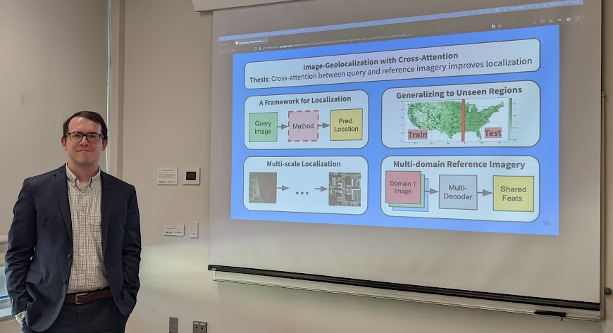
Congrats to @csgreenwell (https://t.co/eBuUpZbcRh) for successfully defending his PhD thesis in Computer Science @ukyengineering! His research focused on image geo-localization with attention-based models. Next stop: @Kitware!
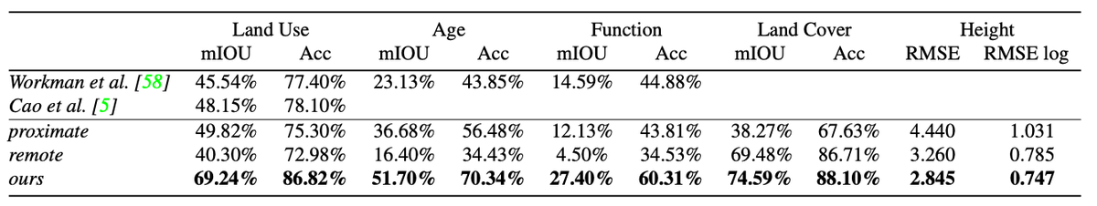
"Revisiting Near/Remote Sensing with Geospatial Attention" w/ former students Scott Workman, @m_usmanrafique, and Hunter Blanton. @CVPR 2022
TL;DR: If you are careful about attention and geometry, you can use street-view imagery to improve satellite image segmentation.
Here's the arxiv: https://t.co/GAePgBNIPn
It does much better than our ICCV 2017 work on the same topic: https://t.co/J3WgQCiRp0. The gains are from a mix of the improved attention model and better feature extraction networks.
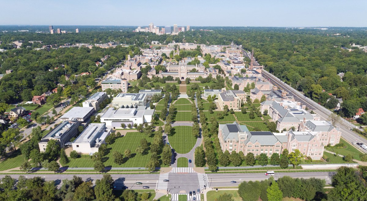
Here's a Google Maps capture looking the other direction. McKelvey Hall is in the bottom left. Forest Park is in the middle, with the art museum and zoo highlighted on the right. You can almost see the St. Louis Arch in the upper left.
Our offices will be in the newly built McKelvey Hall, which you can see in the bottom middle-right of this picture. This is directly across from Forest Park, "one of the nation's greatest urban public parks".
#CVPR2022 outcome: 1 paper accepted, 1 rejected.
The review process is noisy but useful. Happy for the accepted paper and got some good pointers about the rejected one.
Looking forward to @CVPR, hopefully in New Orleans 🙂
w/ @jacobsn and @multimodal_lab
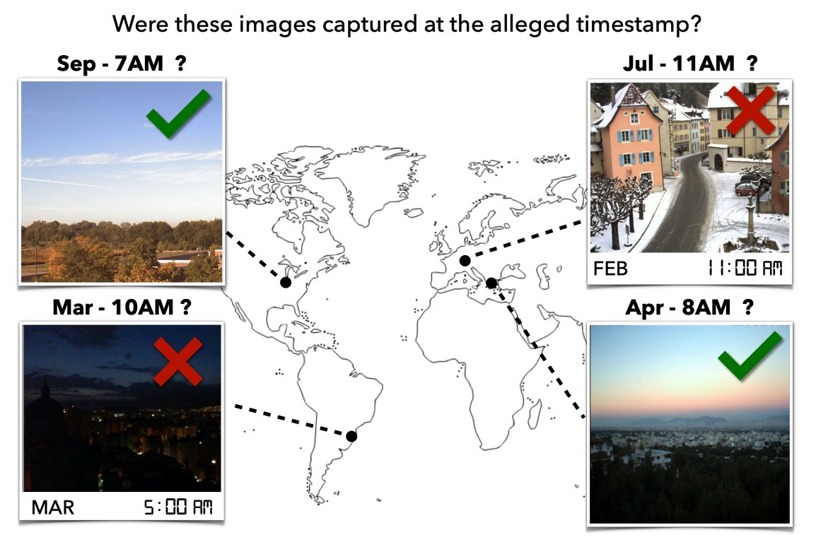
Our paper "Content-Based Detection of Temporal Metadata Manipulation" was accepted to the IEEE Trans. on Information Forensics and Security!
Summary: Given an image and a geographic location, does this timestamp make sense?
https://t.co/uTS5aU4PR3
Lead author: @rafaspadilha
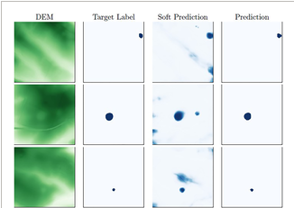
📢📢📢 New paper published at AGU "Earth and Space Science" Journal
Automatic Segmentation of Sinkholes Using a Convolutional Neural Network
w/ Dr. @jacobsn (@multimodal_lab) and Dr. J. Zhu from @KGSNews
Paper: https://t.co/TL41c9fLuO
Code: https://t.co/yPkTqXMB4M
I'm excited to announce I'll be joining the CS&E dept at Washington University in St. Louis in Fall 2022! It's been a great decade+ @UKCompSci (with a wonderfully supportive department). I'll be looking for new collaborators, postdocs, graduate students, housing, ... stay tuned!
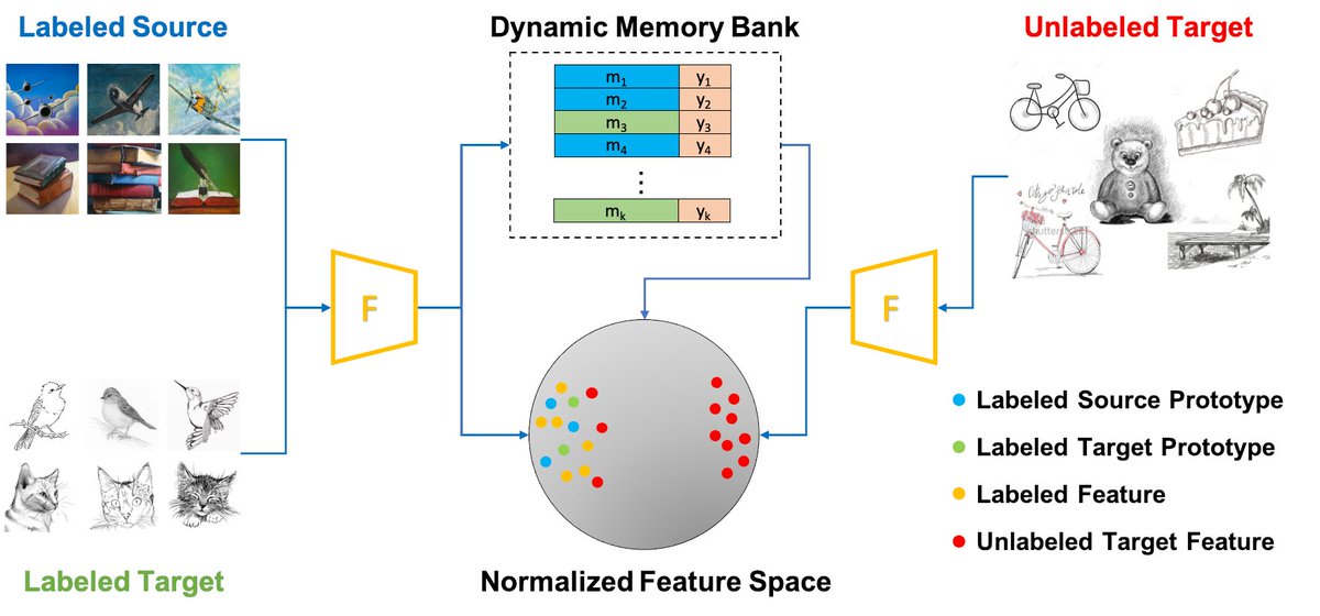
Dynamic Feature Alignment for Semi-supervised Domain Adaptation @BMVCconf
why: we often have some labels in the target domain
idea: align the target features to a set of dynamically updated class prototypes to avoid problems with class imbalances
w/ Yu Zhang and @GB_Liang