𝗙𝗼𝗿 𝘁𝗵𝗲 𝗳𝗶𝗿𝘀𝘁 𝘁𝗶𝗺𝗲 𝗶𝗻 𝗵𝗶𝘀𝘁𝗼𝗿𝘆, 𝗮𝗴𝗿𝗶𝗰𝘂𝗹𝘁𝘂𝗿𝗮𝗹 𝗳𝗶𝗲𝗹𝗱 𝗯𝗼𝘂𝗻𝗱𝗮𝗿𝗶𝗲𝘀 𝗵𝗮𝘃𝗲 𝗯𝗲𝗲𝗻 𝗺𝗮𝗽𝗽𝗲𝗱 𝗮𝘁 𝗴𝗹𝗼𝗯𝗮𝗹 𝘀𝗰𝗮𝗹𝗲.
I've been collaborating with the Fields of the World (FTW) organization for over a year through Taylor Geospatial and it's finally released publicly in cloud storage for anyone to use, at no cost.
I was lucky to organize this alongside my good friend and collaborator @jacobsn (whose handle I failed to track down earlier 😭). Nathan has been organizing these events at different vision conferences for a while now and has the whole enterprise down to a work of art.
I'm excited to see these results! Very cool. Thanks for sharing! Congrats to @fengqiao_ai for the cool method and demo!
See https://t.co/mNWvY0TLat for details!
Underrated demo for Stereo Image generation is available on @huggingface 😉
Try this result by squinting your eyes enough and see this portrait in 3D appearing in the middle before your eyes 🤪
—› https://t.co/EFIEYTbJ1I
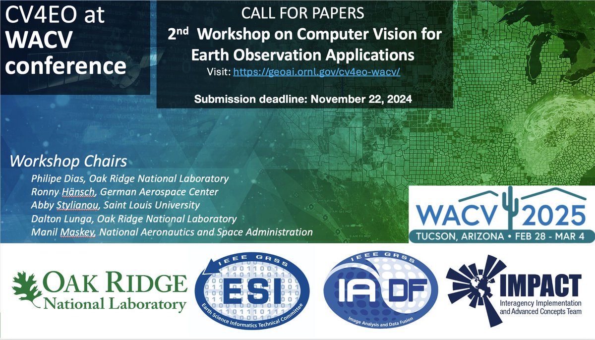
Excited to announce the continuation of the Computer Vision for Hashtag #EarthObservation (CV4EO) Workshop at WACV ! In this 2nd in a series of @IEEE_GRSS workshops we are inviting full research and short/vision papers. https://t.co/GynPlXCL0y
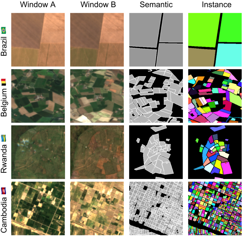
I'm so excited to finally introduce Fields of The World (FTW!) - the largest & most diverse ML dataset for field instance segmentation in satellite images. FTW has >70k samples from 24 countries (4 continents), with semantic & instance labels + Sentinel-2 RGB-NIR from 2 dates. 🧵
Thanks @EarthVisionWS for the recognition, especially after a couple of rounds of rejections at other venues!
Congrats to the team: Aayush (https://t.co/WKp6LaIdRf), @Adeal_GIS, Subash (https://t.co/UNhh0XWVM6), Srikumar (https://t.co/IW3XrTVjvH) and @hannah_kerner!
We are waiting for your papers at the interface of vision 👁 and language 👄 for satellite 🛰 image analysis!
Deadline in September!
With @SylvainLobry@jacobsn@BigEarthBIFOLD and J. Bazi!
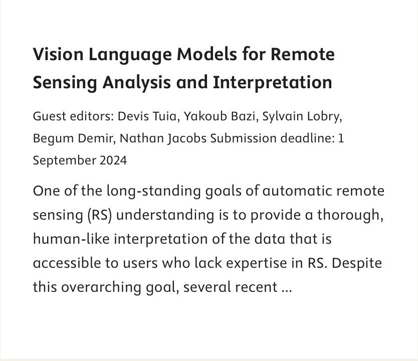
📢 #CallforPapers
📰New special issue in the ISPRS Journal of Photogrammetry and Remote Sensing on
**Vision Language Models for Remote Sensing Analysis and Interpretation**
🗓️Deadline: 01/09/2024
🔗Find the call: https://t.co/O39xNuP0K2
A team of #WashUEngineers researchers developed a visual active search framework for geospatial exploration that may combat complex problems like human trafficking and illegal poaching.
Read more ⤵️
https://t.co/faOm9iFr2p
... "A Visual Active Search Framework for Geospatial Exploration" which addresses the the active search problem (not active learning!) in computer vision! Here's an article about our closely related NeurIPS paper: https://t.co/Qteb12RUnu.
#wacv2024@multimodal_lab
We also have two more cool posters in the same session: "WATCH: Wide-Area Terrestrial Change Hypercube", which introduces a system for remote-sensing change characterization that we've been working on with @Kitware and ...
@rbpless We'll be presenting this work in the poster session at #wacv2024 today! Come and check it out! This is our first work in "computational ecology" so we are excited to share it and discuss it with others interested in the same topics!
@rbpless We'll be presenting this work in the poster session at #wacv2024 today! Come and check it out! This is our first work in "computational ecology" so we are excited to share it and discuss it with others interested in the same topics!