We are proud to have been part of #Interpraevent2024 with our contribution on a method for dynamic hazard assessment in changing alpine environments.
(PDF) Dynamic Hazard Assessment Method of Mass Movements in constantly changing alpine Environments (https://t.co/0bnrHaVcNv)
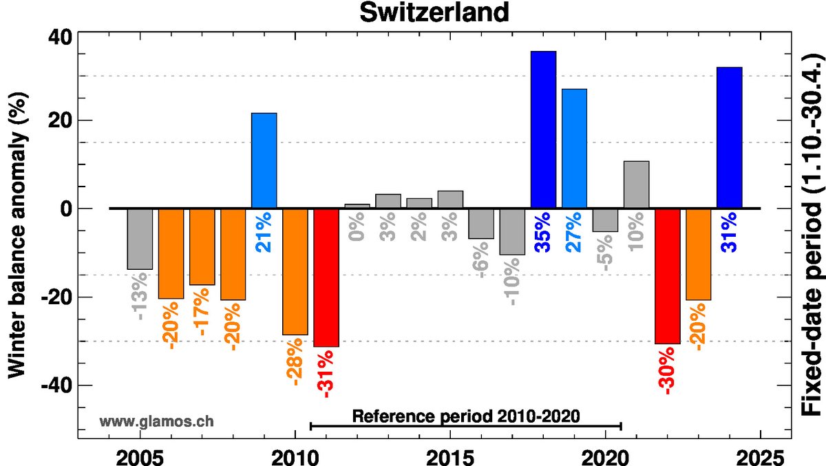
One of the best winter seasons ever for Swiss #glaciers! 31% more #snow than usual. This is good News for the coming summer.
Our surveys of winter snow accumulation on 12 glaciers are almost done. Get the report with data evaluation here: https://t.co/jKAjtRmX8M
Infos zu einem Grundstück, Gebäude oder Wasserlauf gesucht?
Im #Geoportal werden Sie fündig. Neu mit erweiterten Funktionen:
✔️vielfältige Kombinationsmöglichkeiten
✔️mehr Datensätze
✔️schnelle Suche
Jetzt ausprobieren auf ⬇️
https://t.co/dPr0dO46V0
Brilliant new planning guidance to manage landslide risk in New Zealand, produced by @gnsscience, has much wider applicability:- https://t.co/TwTYAyklPx
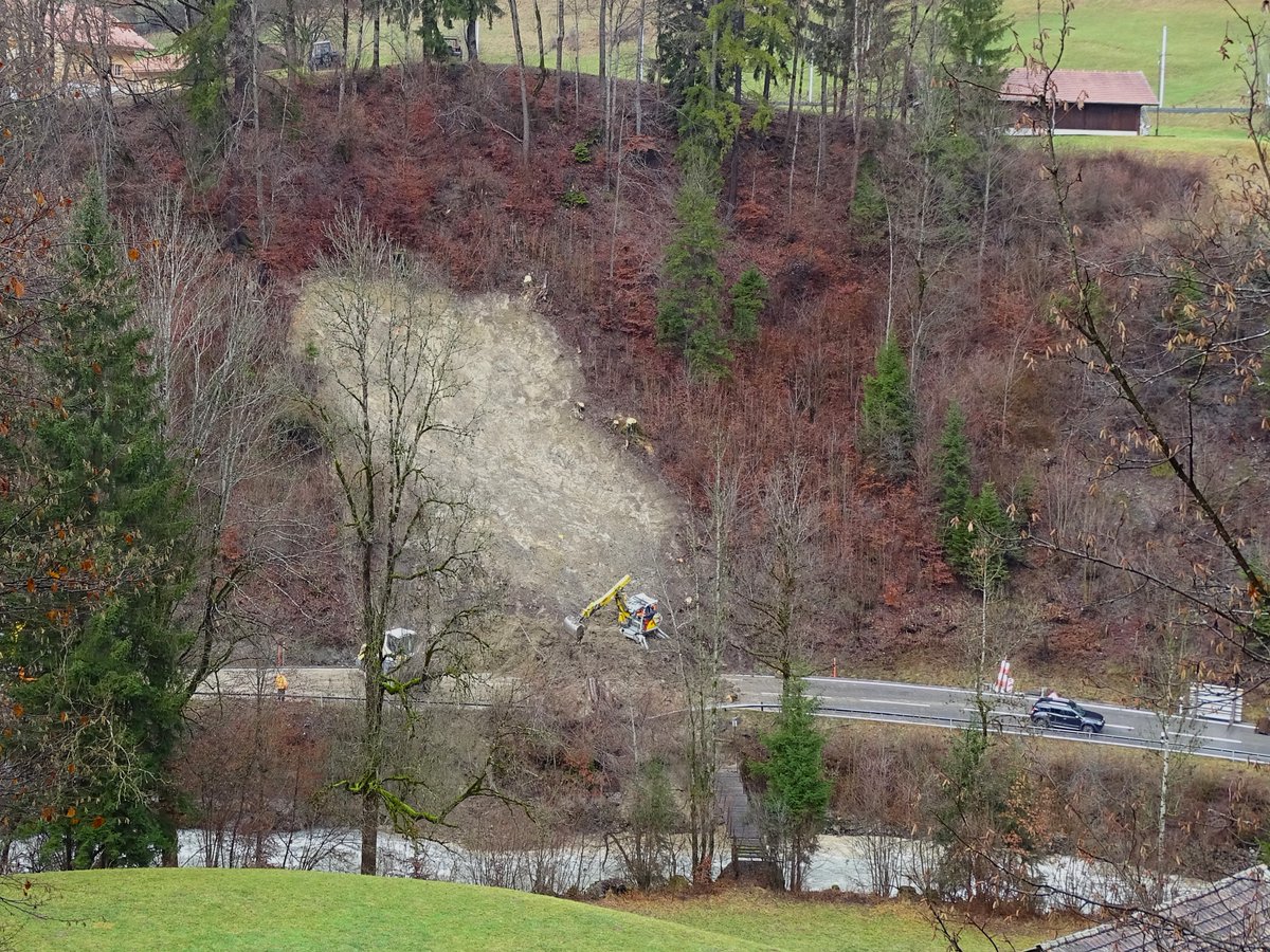
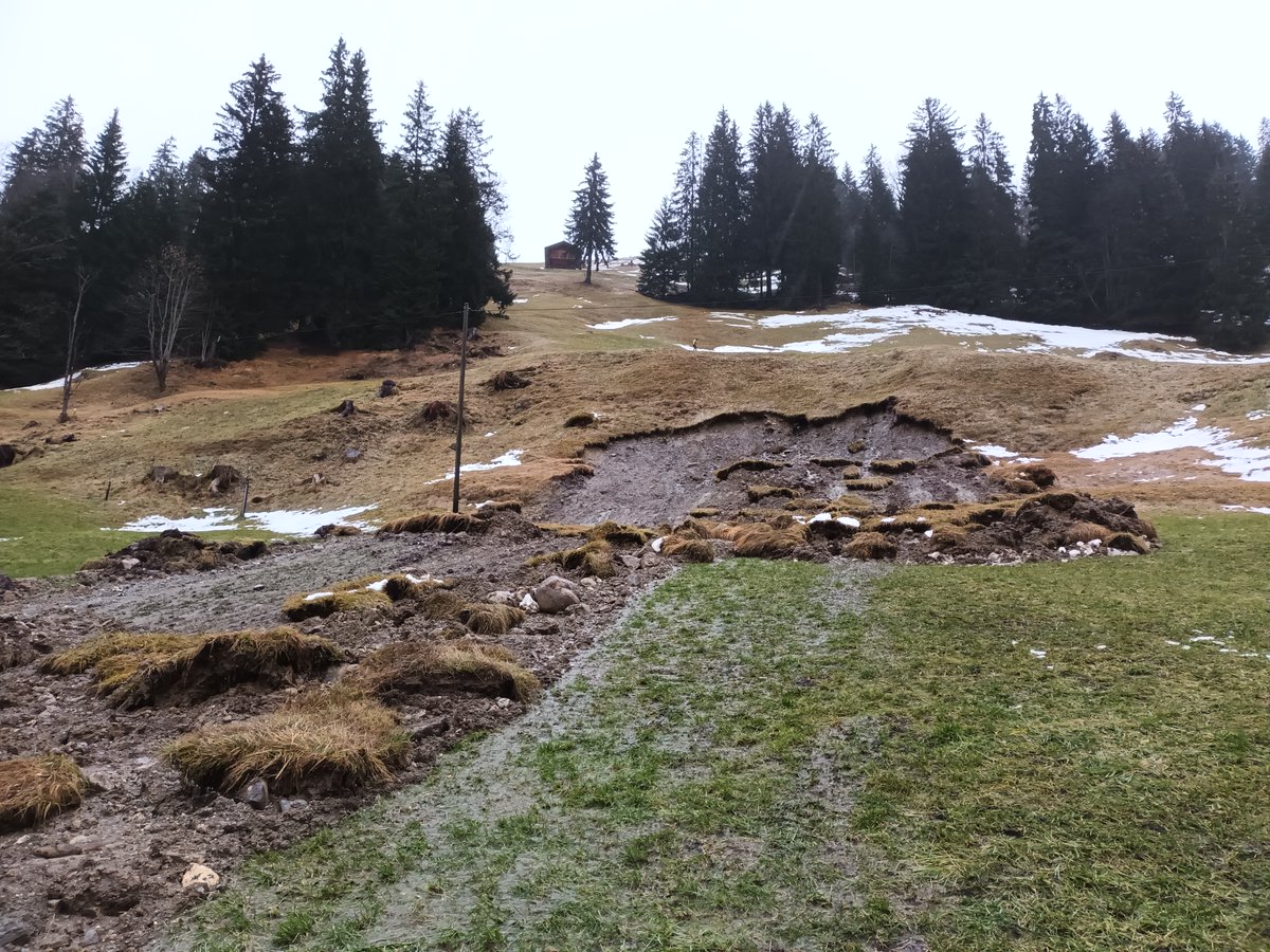
In Wattenwil, Canton of Bern, a permanent landslide has accelerated as a result of the heavy rainfall at the end of 2023. The landslide covers an area of around 50 hectares. There is extensive damage to the forest, forest roads, protection measures and buildings.
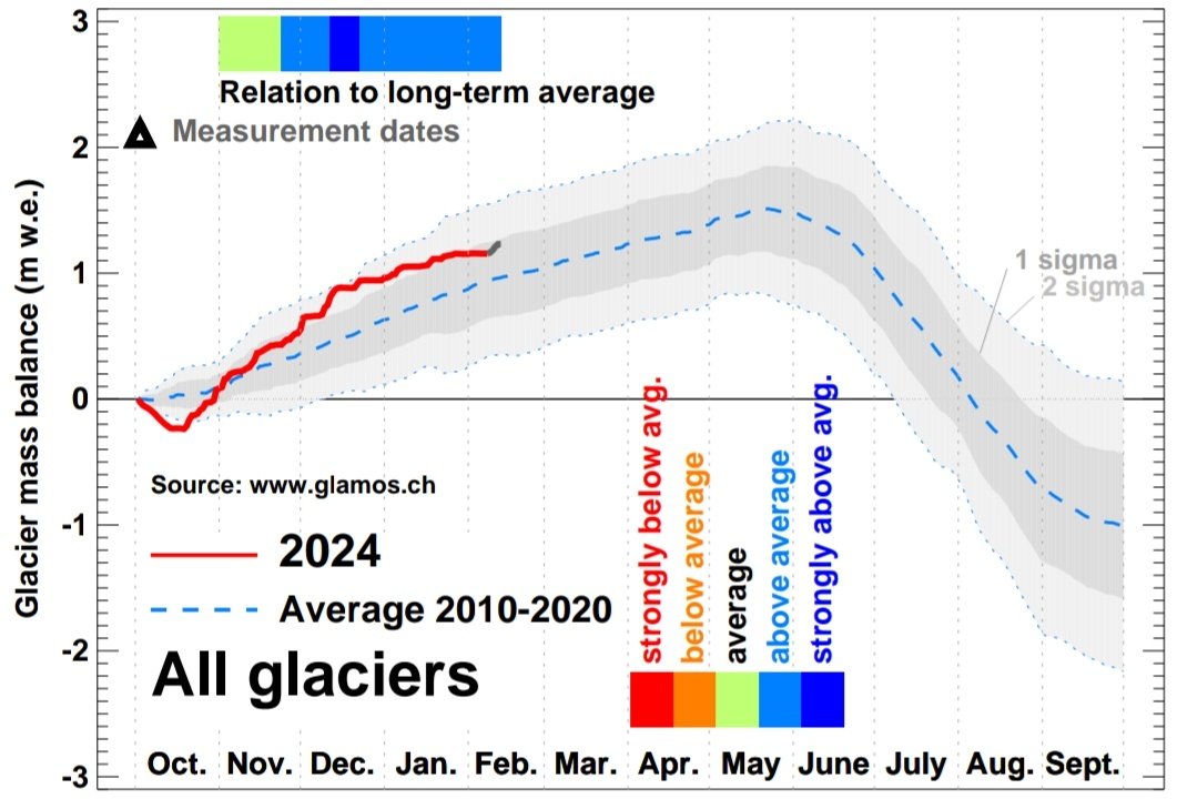
How are Swiss #glaciers doing in this strange winter of 2023/2024? Lots of snow in December but spring temperatures since weeks...
@glamos_ch real-time obs combined with modelling show an OK situation. No snow deficit at high elevation, but regional differences exist:
The heavy rainfall, together with intense snowmelt, has led to a critical flood situation and numerous landslides and rockfalls in the canton of Bern. These events are documented in the event register, as this is an important basis for reliable hazard assessments.
Hochwassersituation ist angespannt. Pegel der Aare sowie des Thuner- und Bielersees steigen weiter an. Regulierdienst verfolgt Entwicklung laufend und ist in Kontakt mit lokalen Einsatzorganen.
Aktuelle Situation➡https://t.co/1Qq44z8FZz
Medienmitteilung ➡https://t.co/cDEUyGggxF
Good example from a @zhdk bachelor project for the comprehensible visualisation of complex data from experts. Elena Kaeser shows one of the possible scenarios of the #SpitzeStei landslide in #Kandersteg.
https://t.co/dabHnsatNL
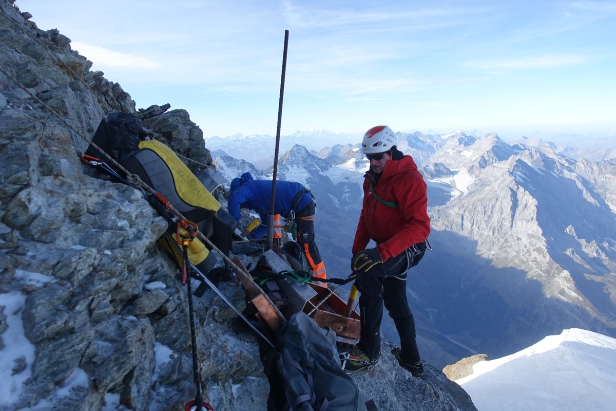
This summer, two 25-metre-deep #permafrost boreholes were drilled on the #Jungfrau at 4130 m above sea level by the canton in collaboration with @SLF. A construction site with a unique view, but great challenges in terms of logistics, construction techniques and work safety.
In the Lauterbrunnen Valley large rock masses are moving in two places. We installed GNSS stations to follow the movement and carry out annual drone surveys. This data provides valuable information for the assessment of such instabilities.
#naturalhazard#climatechange
The numbers are out: Swiss #glaciers lost >4% of their volume in 2023, the second-worst year since measurements started. Wow!
See media-release by @scnatCH
https://t.co/n9uT7VrKPQ
Events like the #Fluchthorn rock avalanche have shown the tremendous impacts of heat waves 🏔️☀️ on #Alpine#permafrost decline! Join @UniFribourg as part of the #TREAT project for an exciting PhD opportunity in hydro-thermal and geophysical modelling.
⏩ https://t.co/bzWi0QzSeQ
The past heat wave has left its mark on Swiss #glaciers. A comparison of images from the Taleggli glacier in the Susten region between 3 and 25 August 2023.
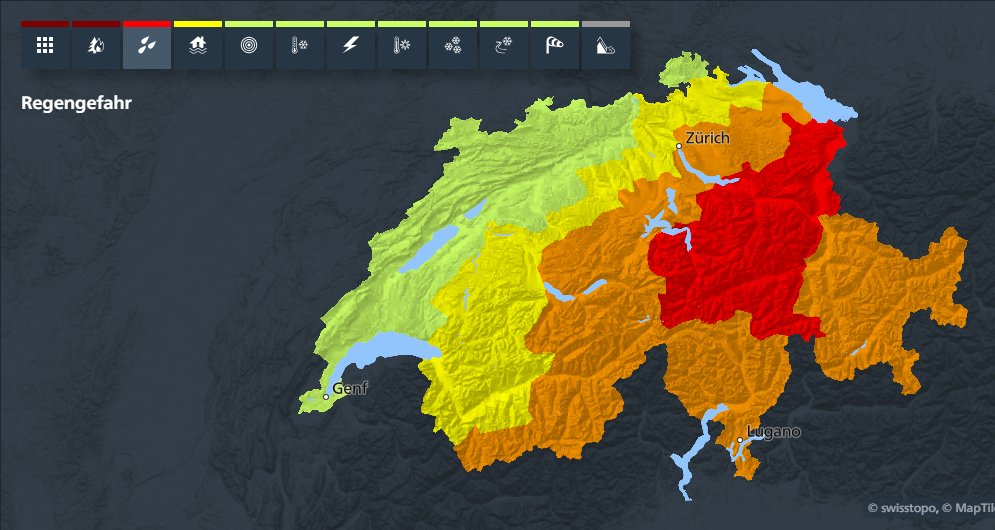
Warnung des Bundes: intensiver Dauerregen. Gefahrenstufe 3 und 4 (von 5). Betroffene Regionen, weitere Informationen und Verhaltensempfehlungen auf https://t.co/fR0rVJKQQO und https://t.co/EVnQ0ywRjT oder auf der MeteoSwissApp. #MeteoSchweiz#Unwetterwarnung