@Nicbudd77@ameliaUrquhart_ The better MPAS core version is hosted on both @aguacerowx and @PivotalWeather from what I've seen. I haven't seen any public REFS outside of DESI (though I don't use DESI often so I could be misremembering whether DESI has the REFS yet)
@askboutderm@ThunderChats Thunder fan here. That shit was reffed horribly on both sides on occasion lol
For example, don't think I've ever witnessed a double foul that wasn't for a tech
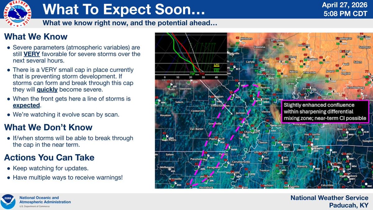
Currently there is a VERY small cap in place that is preventing storm development. If storms are able to initiate and break through this cap they will QUICKLY become severe. Otherwise we are just waiting on the severe line of storms to come through with the front later tonight.
@WeatherSphere22@MajstcSeagull@AZ_Intel_ You linked a different meteorologist from the video, but the one you linked had better footage. The one in the video was News 9
SUNDAY, April 12 in Kansas/Oklahoma will be mostly sunny with a slight chance of a tornado.
And yes, that's the best – and most appropriate – forecast we can give at this time frame. How can that be!?
It's a "conditional" risk; in other words, there are two solutions – all or nothing – and not much in between. The odds of nothing are 85%. The odds of a higher-end severe thunderstorm with a significant tornado risk? 15%.
It's because of something called the "cap". That's the lid of hot, dry air a mile above the ground that prevents surface air from rising and generating storms. The cap will be strong.
IF the cap can break, warm, humid air from below will rise. There's ample instability, or thunderstorm fuel, to generate a rogue severe thunderstorm, and wind dynamics would favor rotation and a tornado risk. But the odds of that happening are low.
Therefore, mostly sunny with a very slight chance of a supercell is the appropriate, albeit frustrating, forecast. Check back for updates.
@ReedP_WX@aguacerowx Current beta tester here. Our leading theory is that it's a tilt issue. Is there a lower tilt available on the radar you're using?