Precision location within minutes of setup. 100x more accurate than GPS with coverage in the United States, EU, UK, Australia, South Korea, and more. 🚗
FUSE San Francisco is a week away (Nov 19) and we are down to our last few seats 🧭
https://t.co/nMlUSwJnKc
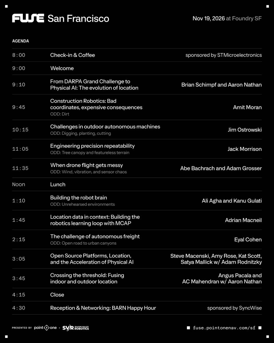
Abraham Bachrach, CTO of @SkydioHQ, is joining us to talk about localization in drone flight. The full agenda is out too.
We organized the day around the conditions that break localization: dirt, tree canopy, wind, open road, urban canyons and unrehearsed environments.
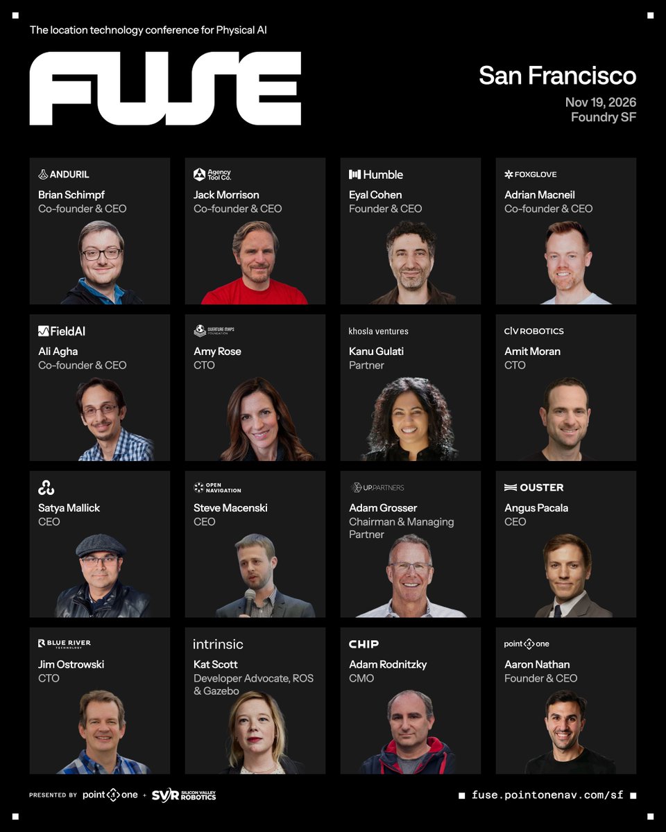
The lineup: @SchimpfBrian (Anduril), @moran_amit (Civ Robotics), Jim Ostrowski (@BlueRiverTech), @jackmorrison (Agency Tool Company), Abraham Bachrach (@SkydioHQ), @adamgrosser (https://t.co/ZCnjhPyRx5), Ali Agha (@fieldai_), @KanuGulati (Khosla Ventures), @adrianmacneil (Foxglove), Eyal Cohen (@humblerobotics), Steve Macenski (Open Navigation), Amy Rose (@OvertureMaps), @kscottz (Intrinsic), @LearnOpenCV, Adam Rodnitzky (BARN), Angus Pacala (@ousterlidar) and AC Mahendran (Point One)
Thank you to @ST_World, @sparkfun, @svrobo and SyncWise for partnering with us. LFG!
FUSE is November 19 in San Francisco - in 15 days! 🧭
🔗 https://t.co/nMlUSwJnKc
People get confused when we say FUSE is not a product conference. What company holds a conference and doesn’t make the audience sit through at least one thinly veiled product pitch?
Point One has a complete product stack for precise location. But that’s not what FUSE is about.
Our team builds robots, and we have a front-row seat as customers take complex machines from prototype to fleets working in the real world.
Location is almost always a big part of that story, and it’s never solved by one technology. GNSS, inertial, cameras, LiDAR, maps, all of it working together.
Fusing them is what’s hard, and it’s why we named the conference FUSE.There hasn’t been a place where the people doing this work could get in a room and say “here’s how we actually made it work.” Until now.
The lineup: @SchimpfBrian (Anduril), @jackmorrison (Agency Tool Company), Eyal Cohen (@humblerobotics), @adrianmacneil (Foxglove), Ali Agha (@fieldai_), Amy Rose (@OvertureMaps), @KanuGulati (Khosla Ventures), @moran_amit (Civ Robotics), @LearnOpenCV, @SteveMacenski (Open Navigation), @adamgrosser (https://t.co/ZCnjhPyRx5), Angus Pacala (@ousterlidar), @kscottz (Intrinsic), Jim Ostrowski (@BlueRiverTech) and Adam Rodnitzky (Bay Area Robotics Network)
Thank you to @svrobo, @sparkfun, @ST_World and SyncWise for partnering with us on this!
If you’re building localization for machines that have to work in the real world, you’re exactly who we had in mind.
FUSE San Francisco | Nov 19 | Foundry SF
https://t.co/nMlUSwJnKc
Point One is partnering with Baltic Towers.
We are bringing our industry-leading, centimeter-level RTK corrections network across Estonia, Latvia, and Lithuania. By deploying Point One’s GNSS reference stations on Baltic Towers' extensive portfolio of approximately 2,700 towers and rooftops, we are enabling drone, survey, agriculture, robotics, and autonomous vehicle teams across all three Baltic states to access 1–2 cm positioning without needing reference stations of their own.
Plus, Baltic Towers is joining as our first customer, using Point One RTK to survey its own towers by drone and build digital twins with incredible precision.
Read the full Press Release by clicking the link in the comments.
We are 23 days out from FUSE San Francisco and we are pumped!
FUSE (https://t.co/nMlUSwJnKc) is the first location technology conference for engineers who are deploying fleets in production. Our speakers are engineers or technical leaders that can share lessons in deploying robotics and autonomy at scale, in real-world conditions.
Earlier this month we ran FUSE in Toulouse, France. It was a great day of talks for a room full of people who build localization systems for a living. We learned about jam-resistant GNSS, train localization at a national rail system scale, interceptor drones, where you get location under jamming, at closing speed, with no second attempt, and LiDAR for when GNSS is simply gone.
These are all very different problems, but IMO they have one thing in common: they are all about solving localization at the edge of your machine's capabilities.
In these cases, what matters is the error distribution, and how often at the tail end that solution has excursions big enough to turn into a bad day.
Exception cases become common events when you scale from the lab to thousands of robots in the field. You can be right 99.99% of the time, but at a hundred thousand units in the field that remaining sliver happens more often than you'd like to think. Inclement weather becomes normal. Trees become normal. Multi-path becomes normal.
That's what the FUSE conference is about. The through-line for the conference is localization under the specific conditions that break it: dirt, tree canopy, featureless terrain, wind and vibration, urban canyons, unrehearsed environments.
We are not going to solve this with just one technology. It happens by all of it working together, which is why we called the conference FUSE in the first place.
We have an amazing lineup: @SchimpfBrian (Anduril Industries), @jackmorrison (Agency Tool Company), Eyal Cohen (@humblerobotics), @adrianmacneil (Foxglove), Ali Agha (@fieldai_), Amy Rose (@OvertureMaps), @KanuGulati (Khosla Ventures), @moran_amit (Civ Robotics), @LearnOpenCV, @SteveMacenski (Open Navigation LLC), @adamgrosser (https://t.co/ZCnjhPyRx5), Angus Pacala (@ousterlidar), @kscottz (Intrinsic), Jim Ostrowski (@BlueRiverTech) and Adam Rodnitzky (Bay Area Robotics Network)
Thank you to @svrobo, @sparkfun, @ST_World and SyncWise for partnering with us on this!
If you are designing, building and deploying localization technology for robots and autonomous vehicles at scale, come spend a day with us! https://t.co/nMlUSwJnKc
An autonomous mower doesn’t get a second chance when positioning fails.
If it drifts 10 cm, you get a crooked stripe. If it drifts 50 cm, it’s in the flowerbed.
That’s why the largest autonomous turf-management companies run Point One.
Come to Equip Expo in Louisville to see centimeter-level positioning built for real job sites.
🗓️ October 20–23 | Booth 11143
👇 Stop by, or book time with our team using the link in the first comment.
#Robotics #Autonomy #GNSS #RTK #EquipExpo
We are super excited that @sparkfun is joining us at FUSE Nov 19 at the Foundry in San Francisco! Grab your ticket and don't miss the 30% off discount code ⬇️ below 😀
We're going to FUSE San Francisco! Hosted by @pointonenav, this event brings together engineers and technology leaders working on the challenges of high precision positioning with robots, autonomous vehicles, drones, or other intelligent machines.
Sign up https://t.co/PlHyJPxlsr
This week we ran the first FUSE location technology conference in Toulouse, France! 🧭
Nine talks, a room full of people who build localization systems for a living. Jam-resistant GNSS. Train localization certified at SIL4. Interceptor drones. LiDAR when GNSS is gone.
Next stop: San Francisco, November 19 at Foundry SF
Register: https://t.co/nMlUSwJnKc
Flooded roads. Collapsed structures. Drone search grids. When the map changes overnight, how precise is your location data?
Point One is heading to Houston for the Natural Disaster Expo at the George R. Brown Convention Center.
Infrastructure fails, response teams still need to know exactly where people, assets, and hazards are. Point One delivers 1–2 cm RTK from a fully owned corrections network, with sensor fusion that holds position when open sky disappears.
Stop by our booth to see how to get centimeter accuracy into your critical response system.
🗓️ Oct 14–15 | George R. Brown Convention Center, Houston
📍 Booth 818
#GNSS #RTK #DisasterResponse #EmergencyManagement
"Check your GNSS signal" is the most common RTK troubleshooting advice. But what does it actually mean? 🤔
Gabriel Amancio, who leads application engineering at Point One, walks through the key metrics that give you an RTK fix:
📡 C/N0 vs. SNR, and why C/N0 is the better yardstick across receivers
📊 The 40 dB-Hz threshold and why you want 8–12 signals above it
⚖️ RTK Fix vs. Float vs. DGNSS: what each one means for accuracy
🛰️ A live lab test with the antenna indoors, then up on the roof in open sky
Position, uncertainty, solution type — that's the easy part. The real diagnostics are in a message you might not be reading. 🛰️
Gabe breaks down what your GNSS receiver is telling you👇
Are you wasting hours post-processing data when your survey had a momentary connectivity issue?
Point One just launched Station Archive Data to solve this headache and save you time.
Join our webinar tomorrow (Tuesday, September 22) at 10AM PT where our Field Application Engineers walk through how to download RINEX and RTCM data from the webapp and via the Point One GraphQL API.
Registration link in the comments
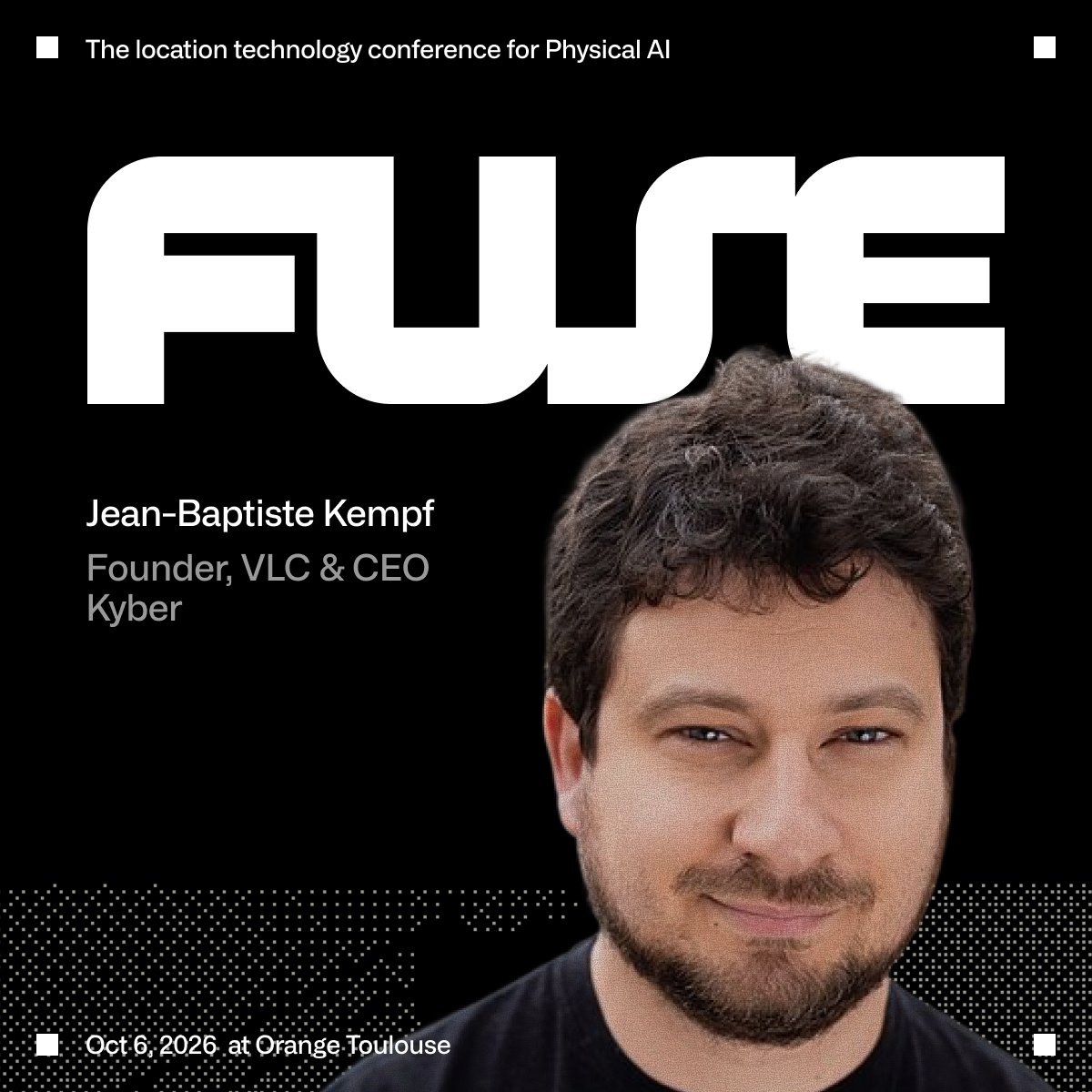
FUSE — the location technology conference for Physical AI — is less than a month away, landing in Toulouse on October 6th at the Orange Innovation Center. 🧭
⏳ Early bird pricing ends Sep 10 — grab your ticket: https://t.co/YczAINzkCH
Jean-Baptiste Kempf spent two decades making sure your video never stalls. Now, as CEO of Kyber, he's chasing a different kind of lag — the one between knowing where a machine is and telling it what to do.
At FUSE, Jean-Baptiste will get into real-time machine control: why closing that latency gap matters, and what open-source thinking brings to robotics that it already brought to media.
A bit about Jean-Baptiste:
🎬 Creator and president of the VideoLAN non-profit, the team behind VLC
🌍 20 years in open source; maintainer of dozens of projects
🚀 Founded multiple startups across multimedia and gaming
🛠️ Former CTO / VP Engineering at Shadow, Vente-Privée, and Scaleway
🤖 Now building Kyber — open technology for controlling machines, drones, and robots in real time
Glad to have Jean-Baptiste on the FUSE stage!
Your rover log is perfect. Now find a base station that was up, nearby, and logging. 🤔
Station Archive is live. Pull reference-station data from the Point One RTK Network by API or straight from the map in the web app.
Join Field Application Engineer David Feng for a live walkthrough on how to download RINEX data.
🗓️ Tuesday, September 22 @ 10am PT
👇 Register for the live session and replay in the comments
#GNSS #RTK #Autonomy #Robotics
Is your GNSS signal good enough for RTK?
Corrections are flowing. Your position is still drifting. What's not working?
Start with signal quality — how many satellites are being used, and how strong is each signal when it reaches the receiver?
In this 10 minute tutorial, Gabe walks through how to:
🛰️ check satellites used vs. satellites tracked
📊 read a C/N₀ (carrier-to-noise density ratio) plot
📡 isolate interference from the other sensors in your stack
This example runs on Point One's Atlas INS, but the metrics apply to any GNSS receiver.