Assistant Professor - Univ. of San Francisco Environmental Science. PhD Univ. of Calgary. 3D Mapping - SfM Photogrammetry - GIS - Drones - Remote Sensing.
Absolutely floored. We got a preview of *now* @VP running mate Tim Walz at the @Esri UC just weeks ago.
Walz’ keynote was inspiring and the talk of the @EsriUC. He is a vet, geography teacher 🌍, and GIS user who understands the value of spatial thinking to solve problems!
Did you know? Minnesota Governor Tim Walz, newly-announced running mate of @VP Harris, was the keynote speaker at our @EsriUC just last month??? Catch his super inspiring talk here:
https://t.co/HBpsM6oW5Y
Cc @leahstokes
🔥🌲Check out this nice 3D smoke app!🌲🔥
It contains a wildfire smoke layer that shows hourly PM2.5 conc. and the forecasted smoke for the next 2 days. In addition, it shows the locations of active wildfires and the air quality index! #ABfire
App link: https://t.co/bDBw8CBoNj
@ThomasM_geo @zzsylvester @mouthofmorrison This! Augmentation has given me mixed results - but rotation seems to help more than the other augs for mapping geologic features. I think it 100% depends on your specific application and ‘range’ of variability in your target objects/data relative to the augs used
🚨 New #data alert! 🚨 The @USGS has collected and released topographic data that show the changes to the Mud Creek #landslide of #BigSur, #California, during the winter of 2024: https://t.co/s5gQtdOUgm
🚨Will you be Canada's 13th Esri Young Scholar?
The application deadline for the 2024 competition is 5 pm ET on Monday, March 25.
Apply now to win a trip to the Esri User Conference in San Diego!
Blog: https://t.co/L3Zzgw4F1B
#GISChat#highereducation#EsriYoungScholar
New data release! Topographic and multispectral reflectance products, aerial imagery, ground spectra, vegetation, and associated GPS data collected during #UAS operations, Cape Cod, MA, October 2021:
(Cramer et al. 2024)
https://t.co/2DCZtulprh
For the first time, a fossilized tyrannosaur has been found with stomach contents preserved in place. Partial remains of two small dinosaurs were discovered inside the stomach cavity of a Gorgosaurus specimen from Dinosaur Provincial Park. Check out this video for details!
Potree got a 38.700k € grant by
@netidee, which will allow me to spend more time on Potree again throughout 2024! 😁
Main goals:
- Migrating from WebGL to WebGPU
- Support for 3D Tiles
- Support for arbitrary point attributes
https://t.co/RZwsLByNZj
https://t.co/gADrUBW5K8
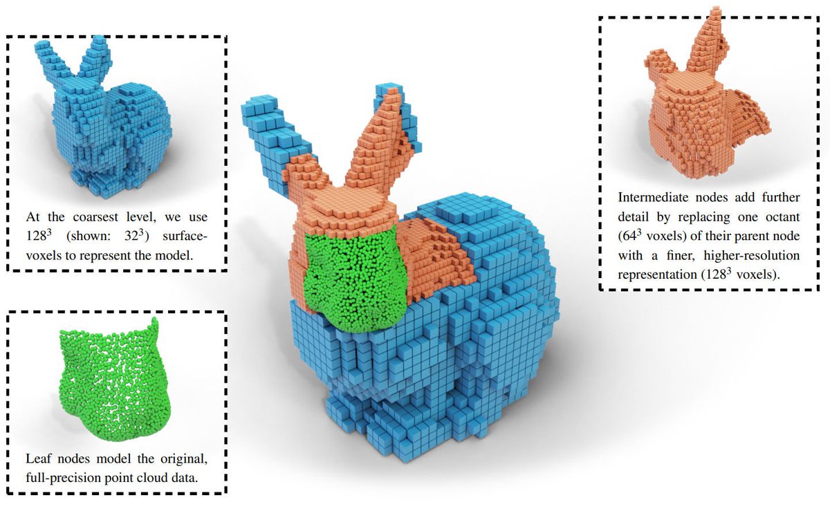
Telheiro angular unconformity between upper Carboniferous metasedimentary rocks (flysch turbidites) and Upper Triassic red sandstones (Vila do Bispo, Portugal), one of 117 3D outcrop models from DDE https://t.co/eUEyxCZff9
Excited to announce that Cloud Optimized GeoTIFF (COG) has been published as official OGC Standard. COG allows for the efficient streaming and partial downloading of web-based imagery and grid coverage data for fast visualization and processing https://t.co/X8fwePNpbD
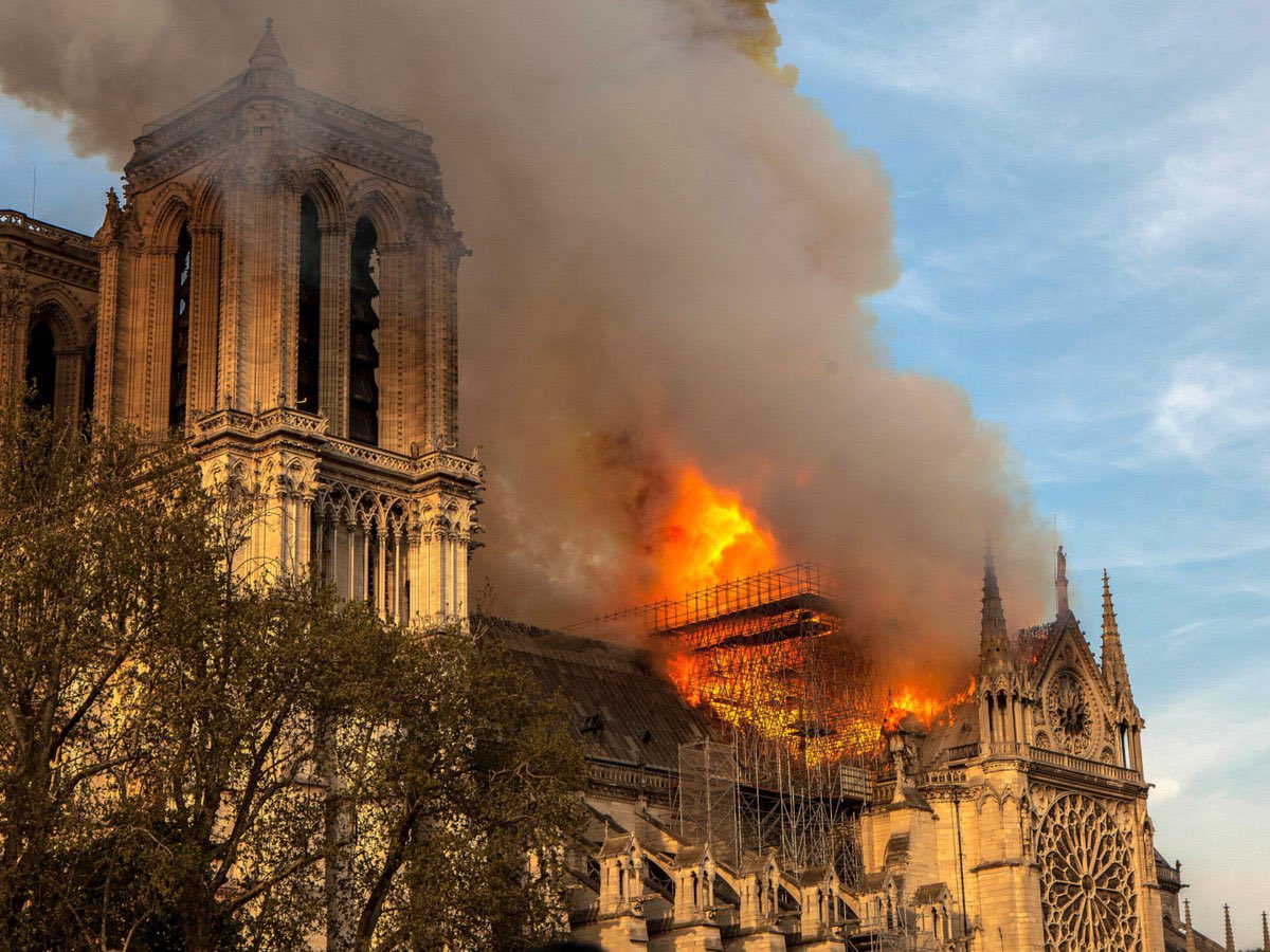
When the Notre Dame Cathedral in Paris was engulfed in flames, Ubisoft, the creators of Assassin's Creed, had previously mapped the cathedral for their game. They generously extended their plans and expertise to assist in the restoration and reconstruction of this iconic structure. Additionally, they contributed €500,000 towards the restoration effort.
As images of the cathedral's roof being consumed by fire began to circulate, Maxime Durand, the historian responsible for ensuring historical accuracy in the "Assassin's Creed" franchise, initially doubted their authenticity. In a phone interview with Business Insider, Durand shared that it took him a full day to articulate his feelings about this devastating event.
Notre-Dame Cathedral held personal significance for Durand. He had spent four years overseeing the creation of "Assassin's Creed Unity," a game set during the French Revolution that featured a remarkably precise representation of Notre-Dame Cathedral as its centerpiece.
In the days following the fire, Ubisoft, the French game developer and publisher behind the "Assassin's Creed" series, pledged €500,000 for the cathedral's rebuilding efforts and offered their extensive expertise. This offer made perfect sense as two Ubisoft team members had invested "over 5,000 hours" in researching Notre-Dame Cathedral, meticulously examining every detail inside and out.
#DidYouKnow that data collected using #drones supports a wide variety of studies, data releases, and scientific publications at USGS?
Learn more:
https://t.co/cjIPTfw8MA
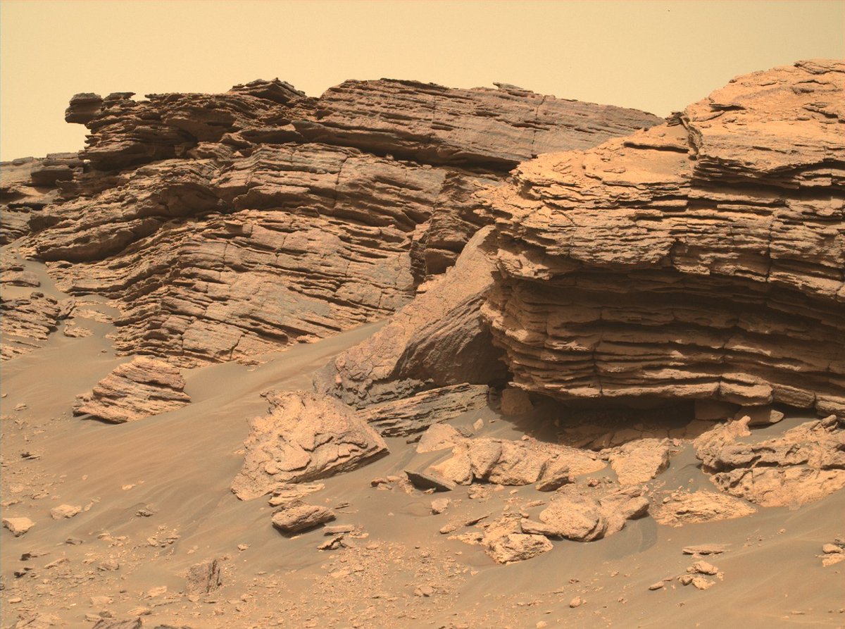
Layer upon layer of rock, like pages in a Martian history book, waiting to be read. The right samples from this area could give us insights like we’ve never seen. I’m getting out my coring drill.
Latest images: https://t.co/Ex1QDo3eC2
🔴 Dive into the most detailed image ever taken on Mars.
Take a guided tour with one of my team members and check out the ancient river delta where I’ve been #SamplingMars and doing science.
A blog post by LinkedIn user Anass YARROUDH 👇
Introducing segment-lidar: Revolutionizing Unsupervised Instance Segmentation of Aerial LiDAR Data
https://t.co/cFQF22oxbZ
#segmentanything#geospatial#lidar
New detailed analysis by @USGS of bathymetric digital elevation models spanning much of #SFBay reveals a net loss of sediment since the 1980s, highlighting the need for ongoing study of the natural and human-caused changes in sediment volume in the Bay: https://t.co/48vxGhbjhR