Geospatial Data Science and Open Source Education. Die hard #opensource and #geospatial fan, including but not limited to @qgis @openstreetmap, @osgeo, #Python.
No doubt this is very extensive and detailed #qgis enchancement proposal but worth reading.
@pleiszenburg good luck with the proposal.
https://t.co/Hx1Pqzejc6
#qgis#qep#python#gischat
#Flood events in #Brazil 🛰️💦 #RioGrandedoSul
Sometimes is difficult to imagine the magnitude of an event unless if compared with a familiar feature, in this case #3D Buildings. Thresholding SRTM by cross-comparing the flooded perimeter with #Sentinel2 NIR band. Rough estimate!
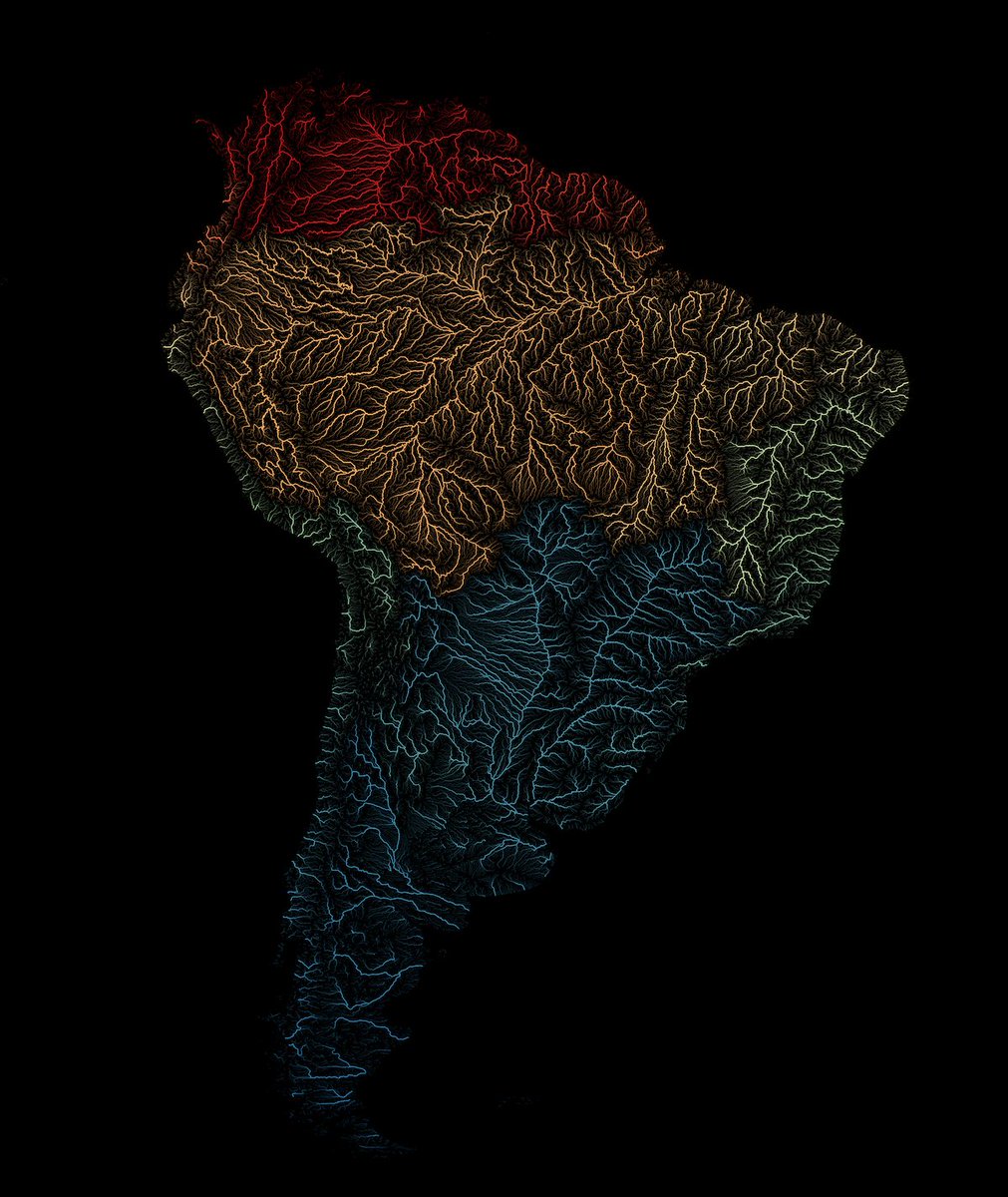
Hot off the presses! A new tutorial in our series focusing on leveraging #QGIS expressions for cartography. @newgeographer2 unveils his techniques for crafting stunning visualizations of rivers using the HydroRIVERS dataset. Check out the tutorial at https://t.co/cSCDRwIalJ
With the explosion of the ash cloud ending, there is another, less flashy but still very interesting thing going on. First off, with weak winds in the troposphere, but easterlies in the stratosphere, the top of the ash cloud is getting sheared off, revealing the tropospheric part
Firenze will be the home of this year edition of #FOSS4G conference! 🇮🇹
Take a look at the official video presentation of #FOSS4G2022 and mark the event dates on your calendar: August 22-28, 2022 🗓
https://t.co/VNDro7WShb
#OSGeo@OSGeo
🚨FULLY FUNDED🚨BSc (#geosciences), MSc (#geography, #GIS) & PhD programs (#geosciences) are still available at our @DEgyetem, Hungary! Students are welcomed from all over the world. Retweet & contact me in case of interest! :)
Deadline is close (15th Jan '22)! Link in comments:
4 Postdoc positions available in quantifying erosion histories with thermo-, geo-chronology and landscape evolution modelling. See link for details. Application deadline Dec. 31. https://t.co/39tlc69BHn
@maphewyk@leyrer@mitsuhiko I can say for Punjabi and Hindi Language. May be other asian language are also like this. See this article for more details. https://t.co/IFdJ2vwdIG
Great to see that Martin's legacy will live on, with his company rapidlasso announcing a new website, developer, and CEO. I know you're watching, with your coffee mug full, Martin. https://t.co/vCFTdKjsed GitHub: https://t.co/2OxpFj2xp8 #foss4g#family
Jonathan Shewchuk of @UCBerkeley provides a wonderful memorial of @LAStools with lots of background into his academic career, including how his mental illness derailed it. https://t.co/q5hfpfsGhO
New #dataviz! The Earth's submarine fiber optic cable network, visualized in #RStats with #rayrender.
Code:
https://t.co/6tFsS4vfAK
Rayrender Github:
https://t.co/iB5nWhGY7l
@howardbutler@LAStools Oh ! Sorry to hear that. We spend time during several meetings like Intergeo, ISPRS, FOSSGIS, and many others. Our discussion was always around two points.
1. Open Source Lidar Formats
2. Carbon Foot Print.
One of those guys, who never talks about money matters.