For 15 days, she swam 3,800 miles (6,000 km) across the Pacific. Achieved a peak of 175 MPH (280 kph) and 909 MBAR. Made landfall over 4 islands in Japan. And became the easternmost-forming Typhoon to reach China on record.
This is the complete lifespan of Super Typhoon Dolphin.
This may be a long loop, but so has been Typhoon Dolphin's existence.
It's already generated >57 ACE units, placing it among the top 10 ACE-producing storms in West Pacific records, while undergoing multiple eyewall replacement cycles and significant structural changes:
Typhoon Dolphin pounds Okinawa, Japan with fierce winds and dangerous conditions. Evacuation orders issued for nearly 260,000 people and 500+ flights canceled.
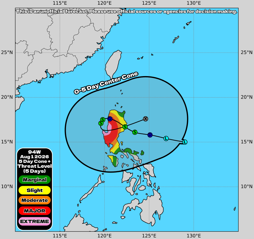
Invest #94W is a surprise threat to the #Philippines, as it could stall and do a loop over Luzon, delivering CATASTROPHIC IMPACTS in the form of flooding, with some areas potentially seeing over 700MM of rain! Will be streaming later today to answer your questions!
#typhoon
Super Typhoon Dolphin has not intensified again to Category 5 due to internal structural problems with its eye. The environment is not pristine with some wind shear and dry air. Still 4,000 miles from China.
UPDATE: Super Typhoon #Dolphin has intensified into a monstrous Category 5 super typhoon, according to the Joint Typhoon Warning Center (JTWC). It has also been classified as a violent typhoon by the Japan Meteorological Agency (JMA). ⚠️
As of 21Z July 29, 2026 (2 AM Manila time, July 30):
JMA: 195 km/h; 920 hPa [10-min] (Violent Typhoon)
JTWC: 270 km/h; 915 hPa [1-min] (Category 5 super typhoon)
Additionally, STY Dolphin has set a new record as the easternmost Category 5 storm to form in the Western Pacific (WPAC) basin, reaching the intensity at 166.5°E. This surpasses STY Faye (1968), which reached Category 5 intensity at 162.7°E.
Meanwhile, the basin has already recorded three Category 5 super typhoons this year, marking the first time to occur since 2015, and the only fifth time since records began in 1945. Also, this marks the first time we have two Category 5 storms in July since 2014 and the only third time in recorded history.
The latest forecast track from JMA has changed very little, maintaining a generally northwestward movement over the next 48 hours before turning west-northwestward as the subtropical ridge (STR) begins to build to the north. Thereafter, the storm is expected to begin tracking more westward on Monday, August 3, as the strengthening subtropical ridge (STR) becomes the dominant steering mechanism.
There is a slight chance that the eye of STY Dolphin may skirt the northeastern tip of the Philippine Area of Responsibility (PAR), while moving towards the Ryukyu Islands. If this occurs, the storm will be assigned the domestic name #LuisPH by PAGASA. Model guidance also indicates that the system may begin enhancing the Southwest Monsoon (#HabagatPH) by the middle of next week.
📷: Himawari-9 via CyclonicWX and Dapiya, JMA, CIMSS
🚨 New PolarWx Site Launch 🚨
After a long time planning the next steps for PolarWx, phase 1 has rolled out this evening with a completely revamped real-time tropical cyclone monitor website.
Check it out below or read the thread for more on what's new:
https://t.co/hx2aMBrtm9
In a visceral case of explosive intensification, Pacific Typhoon Dolphin has detonated from a 45 MPH Tropical Storm to a pinhole-eye buzzsaw in just 24 hours.
Officially, Dolphin’s sustained winds have jumped by an incredible 70 MPH over that time. The problem is, that’s almost certainly a significant underestimate of the storm’s true strength right now.
Based on her current satellite presentation, with a fully cleared eye only a few miles in diameter, an icy CDO of -110 F (-79 C) convection, and violently spiraling gravity waves, Dolphin is likely at least ~20 MPH stronger and 10-20 mbar more intense than the low-end Category 3 strength estimated by the JTWC in their last update.
What’s more, Dolphin is far from finished with this ongoing burst of intensification, and at this rate she could easily push for Category 5 Super Typhoon intensity by the afternoon hours if an EWRC doesn’t begin soon.


![MattWestPacWX's tweet photo. UPDATE: Super Typhoon #Dolphin has intensified into a monstrous Category 5 super typhoon, according to the Joint Typhoon Warning Center (JTWC). It has also been classified as a violent typhoon by the Japan Meteorological Agency (JMA). ⚠️
As of 21Z July 29, 2026 (2 AM Manila time, July 30):
JMA: 195 km/h; 920 hPa [10-min] (Violent Typhoon)
JTWC: 270 km/h; 915 hPa [1-min] (Category 5 super typhoon)
Additionally, STY Dolphin has set a new record as the easternmost Category 5 storm to form in the Western Pacific (WPAC) basin, reaching the intensity at 166.5°E. This surpasses STY Faye (1968), which reached Category 5 intensity at 162.7°E.
Meanwhile, the basin has already recorded three Category 5 super typhoons this year, marking the first time to occur since 2015, and the only fifth time since records began in 1945. Also, this marks the first time we have two Category 5 storms in July since 2014 and the only third time in recorded history.
The latest forecast track from JMA has changed very little, maintaining a generally northwestward movement over the next 48 hours before turning west-northwestward as the subtropical ridge (STR) begins to build to the north. Thereafter, the storm is expected to begin tracking more westward on Monday, August 3, as the strengthening subtropical ridge (STR) becomes the dominant steering mechanism.
There is a slight chance that the eye of STY Dolphin may skirt the northeastern tip of the Philippine Area of Responsibility (PAR), while moving towards the Ryukyu Islands. If this occurs, the storm will be assigned the domestic name #LuisPH by PAGASA. Model guidance also indicates that the system may begin enhancing the Southwest Monsoon (#HabagatPH) by the middle of next week.
📷: Himawari-9 via CyclonicWX and Dapiya, JMA, CIMSS](https://pbs.twimg.com/media/HObmn6-bMAEyqwW.jpg)
![MattWestPacWX's tweet photo. UPDATE: Super Typhoon #Dolphin has intensified into a monstrous Category 5 super typhoon, according to the Joint Typhoon Warning Center (JTWC). It has also been classified as a violent typhoon by the Japan Meteorological Agency (JMA). ⚠️
As of 21Z July 29, 2026 (2 AM Manila time, July 30):
JMA: 195 km/h; 920 hPa [10-min] (Violent Typhoon)
JTWC: 270 km/h; 915 hPa [1-min] (Category 5 super typhoon)
Additionally, STY Dolphin has set a new record as the easternmost Category 5 storm to form in the Western Pacific (WPAC) basin, reaching the intensity at 166.5°E. This surpasses STY Faye (1968), which reached Category 5 intensity at 162.7°E.
Meanwhile, the basin has already recorded three Category 5 super typhoons this year, marking the first time to occur since 2015, and the only fifth time since records began in 1945. Also, this marks the first time we have two Category 5 storms in July since 2014 and the only third time in recorded history.
The latest forecast track from JMA has changed very little, maintaining a generally northwestward movement over the next 48 hours before turning west-northwestward as the subtropical ridge (STR) begins to build to the north. Thereafter, the storm is expected to begin tracking more westward on Monday, August 3, as the strengthening subtropical ridge (STR) becomes the dominant steering mechanism.
There is a slight chance that the eye of STY Dolphin may skirt the northeastern tip of the Philippine Area of Responsibility (PAR), while moving towards the Ryukyu Islands. If this occurs, the storm will be assigned the domestic name #LuisPH by PAGASA. Model guidance also indicates that the system may begin enhancing the Southwest Monsoon (#HabagatPH) by the middle of next week.
📷: Himawari-9 via CyclonicWX and Dapiya, JMA, CIMSS](https://pbs.twimg.com/media/HObl8dHaYAAdN3h.jpg)