We’re partnering with @EYnews on their new #OpenScience Data Challenge, asking participants to use our #satelliteimagery and @Microsoft’s Planetary Computer to build #machinelearning models to help coastal communities become more resilient. Details: https://t.co/W5FANgSs26
The #space industry needs fresher, innovative business models, a few current examples being Pay-Per-Use, X-as-a-Service, Lease/ Time Share & PPP, shares @SaiArul9 - AGI GC Member & Head of Region #SAARC, @Maxar, at GeoSmartIndia 2021.
Maxar’s Madhav Ragam, VP Asia Pacific, talks about super-charging Earth Intelligence using #space technologies and the types of use cases that high-resolution #satellite imagery is enabling today and for the future. https://t.co/X6aYEk5Lfa
New imagery collected today, Feb. 14, of the Fukushima prefecture in Japan and the aftermath of the recent magnitude 7.1 earthquake that struck offshore on Feb. 13 revealed efforts in progress to clear a landslide along the Joban Expressway near Soma City.
Our cloud-based, #geospatial subscription service, #SecureWatch, has surpassed 200 customers, roughly doubling in the past year. SecureWatch gives you on-demand access to the world’s most recent, high-res #satellite imagery and geospatial data. https://t.co/q6hs3RnskD
Maxar was selected by the U.S. Department of Homeland Security to develop an analytics system for characterizing and tracking the behavior of vehicles in multiple domains at scale and in near-real-time. https://t.co/pQg1JXpC19
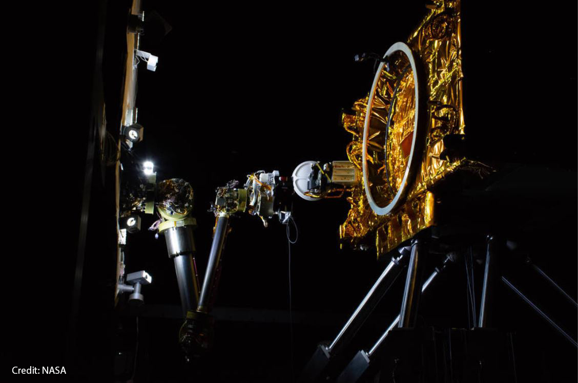
The OSAM-1 (formerly Restore-L) #satellite servicing program successfully passed an important @NASA milestone called KDP-C. We're building the #spacecraft bus and three robotic arms for OSAM-1, which will demonstrate on-orbit assembly and manufacturing. https://t.co/lqaCTs84PV
Today, we announced an order for multiple 1300-class satellites, in the range of several hundred million dollars. Combined with Q1 bookings, this order brings the tally to roughly $700M for the year. https://t.co/178JzIJR1M
We’re excited to announce that we’ve been selected to support @Dynetics, a wholly-owned subsidiary of Leidos, in designing and building a Human Landing System for @NASA’s #Artemis program. https://t.co/o0V0R9n3ag
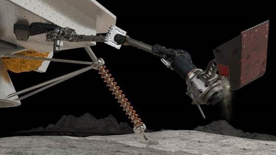
Our SAMPLR robotic arm was chosen to be the first robotic arm on the surface of Earth’s #Moon since the Surveyor missions more than 50 years ago. It will be one of 12 payloads that @NASA has selected as part of the #Artemis program. https://t.co/GkQSILPAsl
Our CEO Dan Jablonsky shared an update on the operational status of our business, some of the actions Maxar has taken and his perspective on the critical role that our industry will play throughout the duration of this crisis and beyond. #COVID19 https://t.co/qmnypmYhmz
Collaborating with @TRIAD_Global and NTT DATA we have announce the results on a proof of concept to build #automated HD #maps for automated driving using commercial #satellite imagery. https://t.co/WsAdAgGTD1
Our next-generation #satellite constellation, WorldView Legion, will be launching in early 2021. This advanced constellation will offer high-agility point collects for #monitoring, near-real time change detection and timely #analysis at scale. Learn more: https://t.co/Lq038lgV7a
We have decades of experience designing, building & operating the most sophisticated commercial Earth observation satellites. With flexible spacecraft, leading modeling software & systems integration expertise we're a trusted partner for critical missions. https://t.co/tCIJaVQ0qO
AI, IoT and high resolution geo-spatial imaging will have a huge impact on making the loss claims after natural disasters to be even more frictionless in the future ! https://t.co/mcuOqvgm3Y