Prescient Weather co-founder. Norway, London, Cambridge, Penn State, N Georgia. Weather and climate enthusiast since the UK's Great Storm of 1987. Alaskaphile.
Setting up a new profile for personal posts - mostly weather, climate, and Alaska.
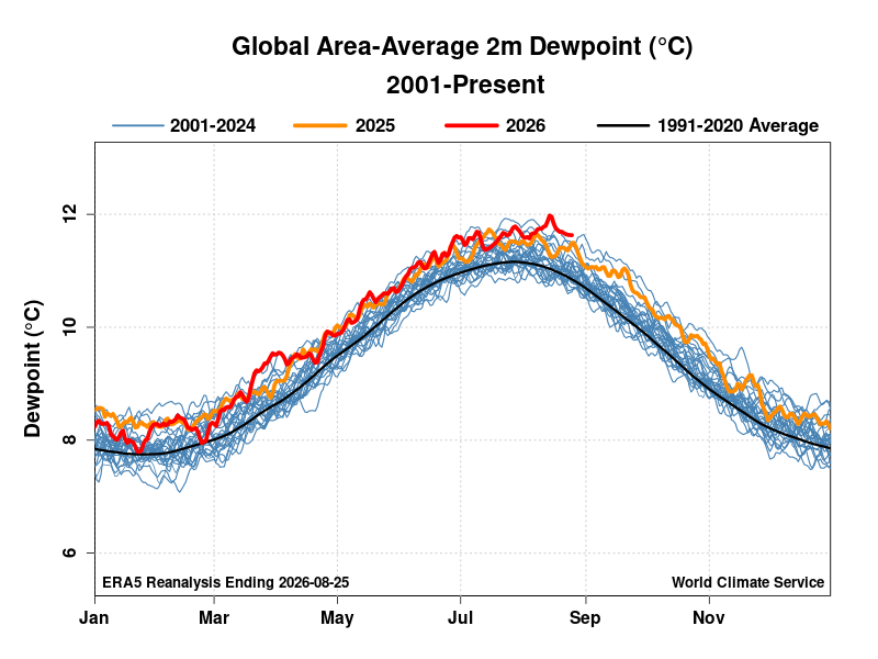
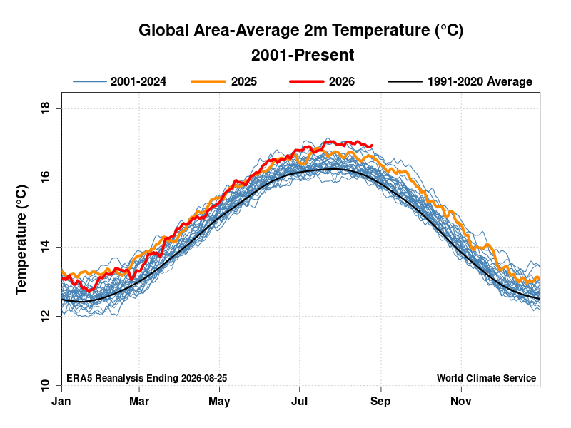
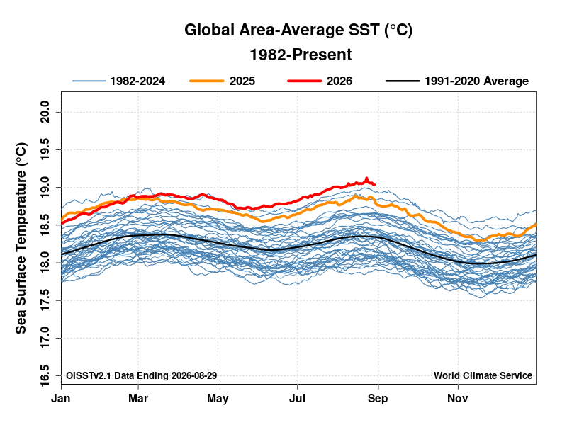
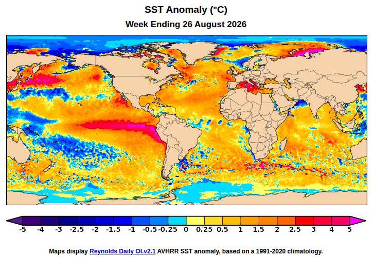
Let's start with a big picture view: latest data show record high global-average SST, 2m temps, and 2m dewpoints.
Related: very strong El Niño conditions
Not to downplay the magnitude and global impacts of this extreme El Niño - but it's scientifically interesting to see Niño3.4 SSTs still lagging the seasonal models by more than 0.5°C.
The UK Met Office model back in September seems to have been closest to the mark.
Update on this: Niño3.4 could still get to the +4°C peak predicted by recent seasonal model runs, but it's still lagging.
Very little practical difference, of course - extreme El Niño is ongoing.
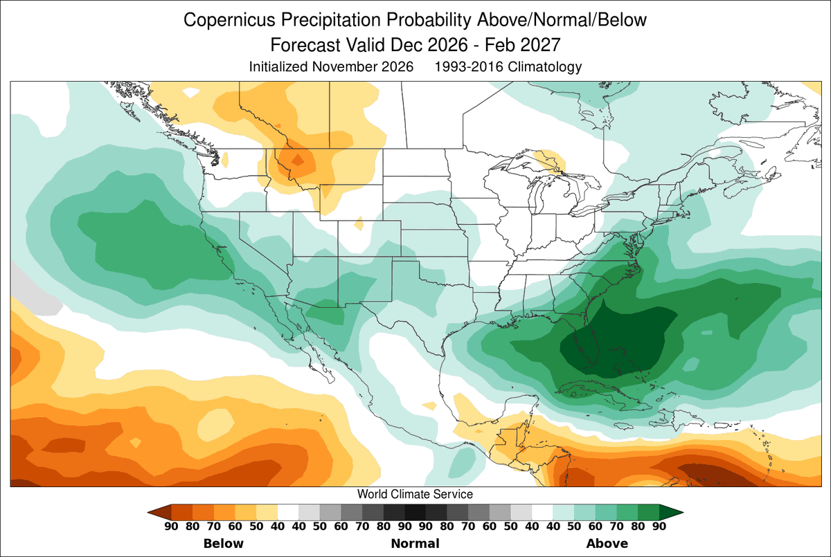
The excessive rainfall highlights in California and Florida today bear an uncanny resemblance to the highest above-normal precip seasonal forecast probabilities.
But it's not a coincidence. #ElNino
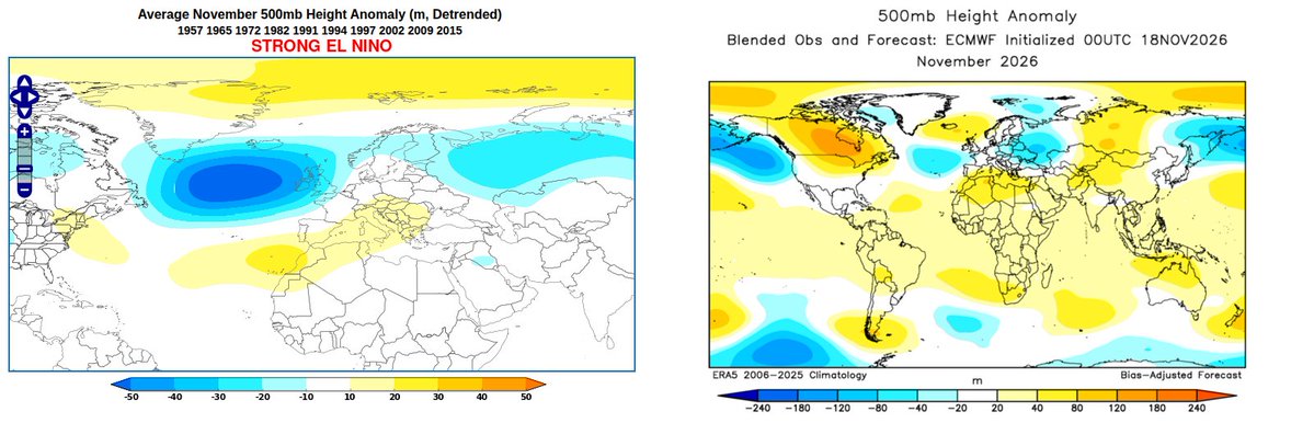
The divergence from "typical" strong El Niño patterns has been relentless in recent months across the Atlantic and Europe.
Historical patterns on the left, actual on the right.
Tough times for analog forecasts.
Wintry scenes in Bettles, Alaska, today (northern interior valley location)
Season-to-date snowfall is over 52 inches, a record for the date.
Very mild temperature of +25°F this afternoon, compared to a normal daily max of +6°F
From @russ_schumacher at Colorado State: last week's rains in southern Colorado "should clearly be added to the list of the most extreme rainstorms in Colorado history"
https://t.co/Uz9nxYImHl
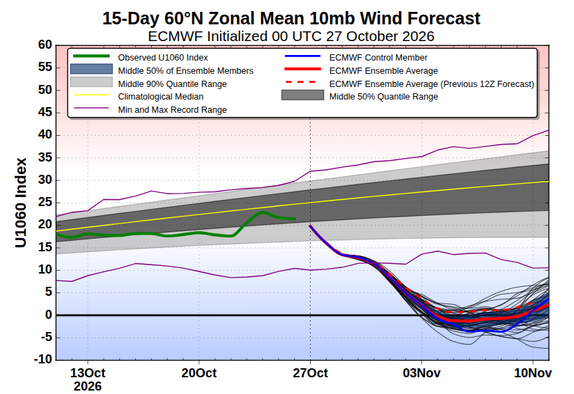
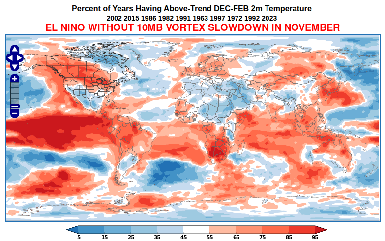
Another reason to be surprised at the impending stratospheric vortex breakdown: the ongoing super El Niño.
El Niño years WITHOUT a 10mb vortex slowdown in November were nearly all very robust El Niños, including the 4 strongest.
This super El Niño is not like the others.
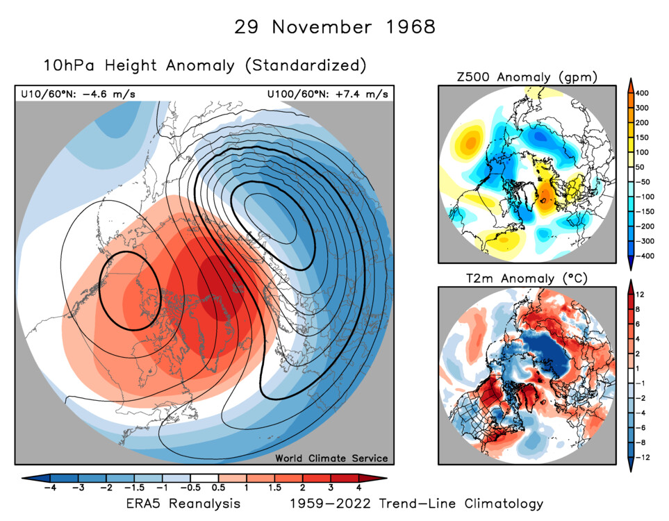
Fascinating to see a major stratospheric polar vortex breakdown so early in the season - when radiative spin-up is usually much stronger than planetary wave forcing.
Even the November SSW of 1968 was a vortex displacement, but we're looking at a real vortex split next week.
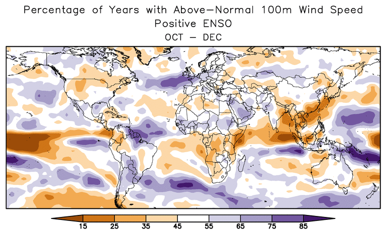
Strong winds today and tomorrow in northern France and the southern UK (in particular) are right in line with seasonal model indications of enhanced wind for late autumn and early winter.
It's a classic El Niño signal for the time of year.
It's sunny. The main reason it's sunny is that there aren't any clouds, which is allowing for more sunshine. The sky is clear, which means it's blue, except at night when it will be clear but not blue because it will be dark.
It's also dry. That's the reason it hasn't been raining. With no rain expected, the dry weather will continue to be dry. The sunshine will also continue, making it sunny and dry at the same time.
Looking ahead, more sunny, dry, and clear weather is expected. Some days may be sunnier than others, but even the less sunny days will still be mostly sunny. The clear skies will remain clear unless clouds develop, in which case they will be less clear but still dry.
By the weekend, we're expecting continued sunshine with dry conditions and generally clear skies. In other words, sunny, dry, and clear, followed by more sunny, dry, and clear.
We'll keep an eye on things, but at this point there is very little to keep an eye on because the skies are so clear.
What's remarkable is how stubborn the EPS/GEFS vs. AI guidance split is - there is a near total split in track as soon as 2-3 days from now.
Much of this stems from AI models having weaker easterly steering flow, leading to a slightly slower storm that turns north farther east.
Arctic sea ice contrasts
Very rapid ice growth on the Pacific side so far this season, and back above the 1991-2020 normal (Beaufort and Chukchi Seas)
But far below normal on the Russia side
Update on this: Niño3.4 could still get to the +4°C peak predicted by recent seasonal model runs, but it's still lagging.
Very little practical difference, of course - extreme El Niño is ongoing.
It's starting to look more likely that El Niño may not achieve the peak Niño3.4 SST anomaly predicted by the seasonal models in the past couple of months.
Still a long way to go, however.
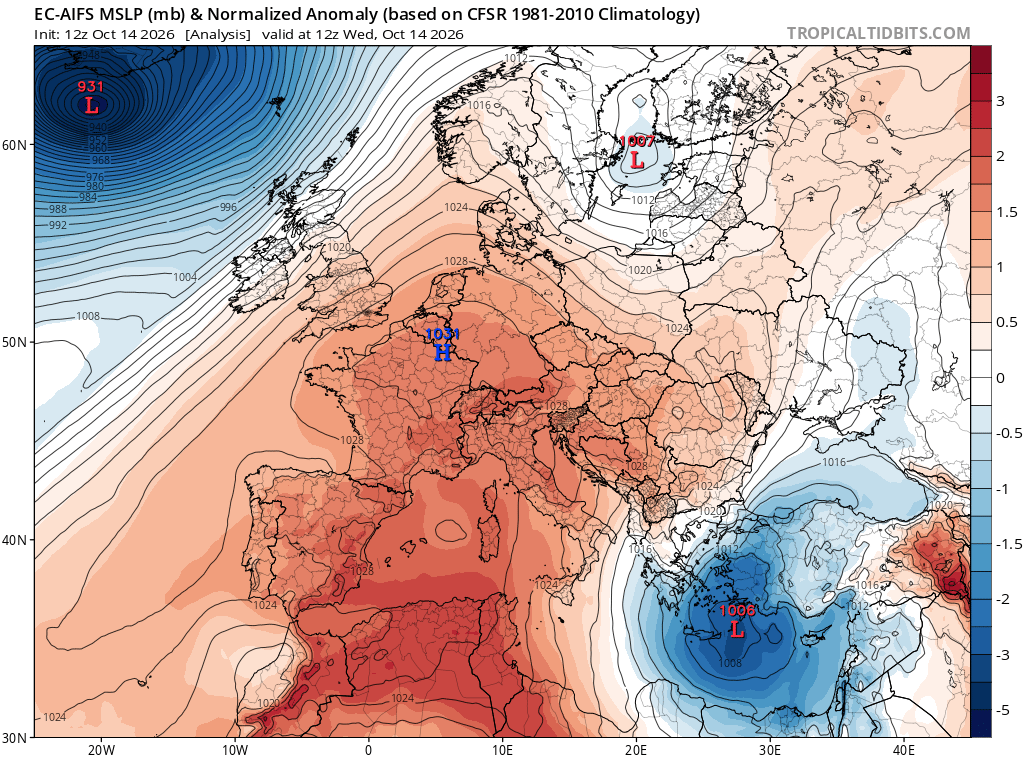
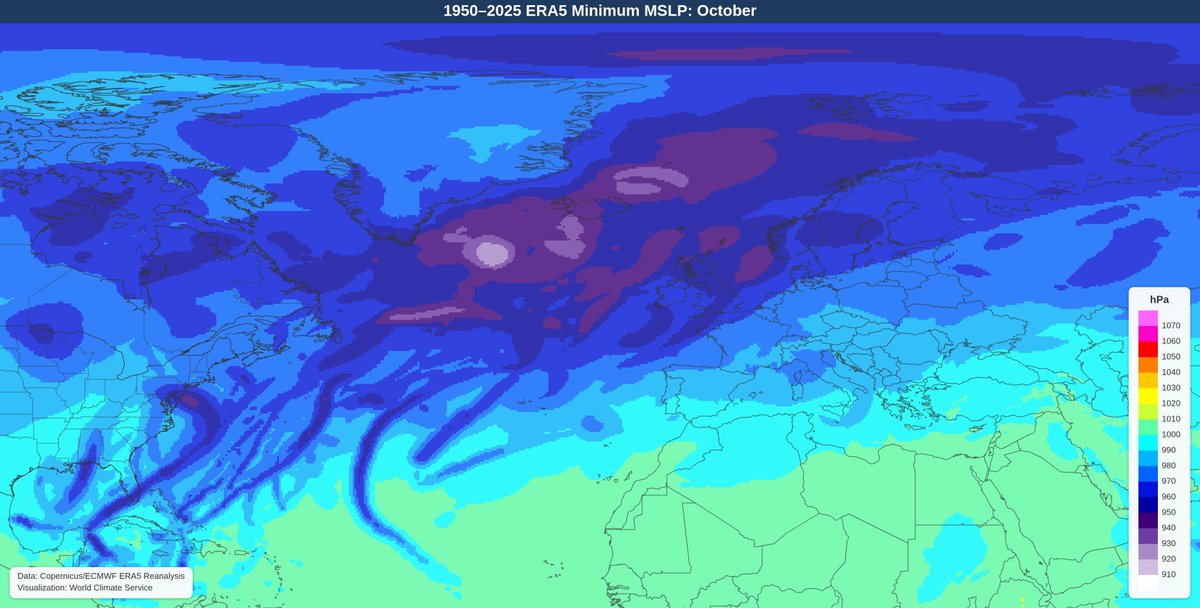
AIFS had the Icelandic low at 931mb at 12UTC today.
Assuming ERA5 is similar, this will easily be the lowest MSLP in the vicinity of Iceland outside of the winter months of Dec-Jan-Feb (1950-2025 data).
Latest HRRR forecast showing upwards of 8-10" of rain locally in the western North Carolina highlands tomorrow into early Sunday.
Hurricane Isaias "isn't another Helene", but the rain and flood risk is very significant nonetheless.