Severe thunderstorms are expected in our area on Monday. Damaging winds, large hail, and tornadoes are possible. Please stay weather aware and be ready to take action if warnings are issued.
A strong cold front approaches the area Monday, with strong to severe storms likely from late morning through the evening. Impacts from this system could be significant. All severe hazards are possible, w/ damaging winds & isolated tornadoes the primary threats #vawx#ncwx#mdwx
Honored to attend the rollout of Pillar Two of the City’s budget with Richmond Mayor Danny Avula.
Pillar Two reflects a commitment to strengthening our neighborhoods, investing in opportunity, and building a safer, more equitable Richmond for every resident.
🚧 Traffic Advisory – Lobby Day (Mon., Jan. 19)
Street closures from 8 a.m.–5 p.m. in downtown Richmond.
🚦 Affected streets:
• 9th St. (Main–Broad)
• Franklin St. (8th–9th, state access only)
• Grace St. (8th–9th)
Plan ahead and use alternate routes.
Expect loud blasts on Saturday, Jan. 17, 2026, at approx. 12:31 p.m. around the Capitol Square and downtown area. A scheduled cannon fire, artillery salute, and military aircraft flyover is a scheduled part of the inauguration ceremony. There is no risk to public safety.
A Cold Weather Advisory remains in effect tonight, with wind chills of 5-10°F expected or currently ongoing. Wind gusts of 25-30 mph inland, and gusts as high as 45 mph along the coast will continue over the next few hours before quickly decreasing late tonight.
2 pm ET Sun, Sep. 7: Tropical cyclone formation is not expected in the Atlantic during the next 7 days.
Yes, you read that correctly, even with the normal peak of the hurricane season just 3 days away! But that doesn't mean things can't change quickly. As always, monitor https://t.co/Wq6ZtKfHp9 for the latest.
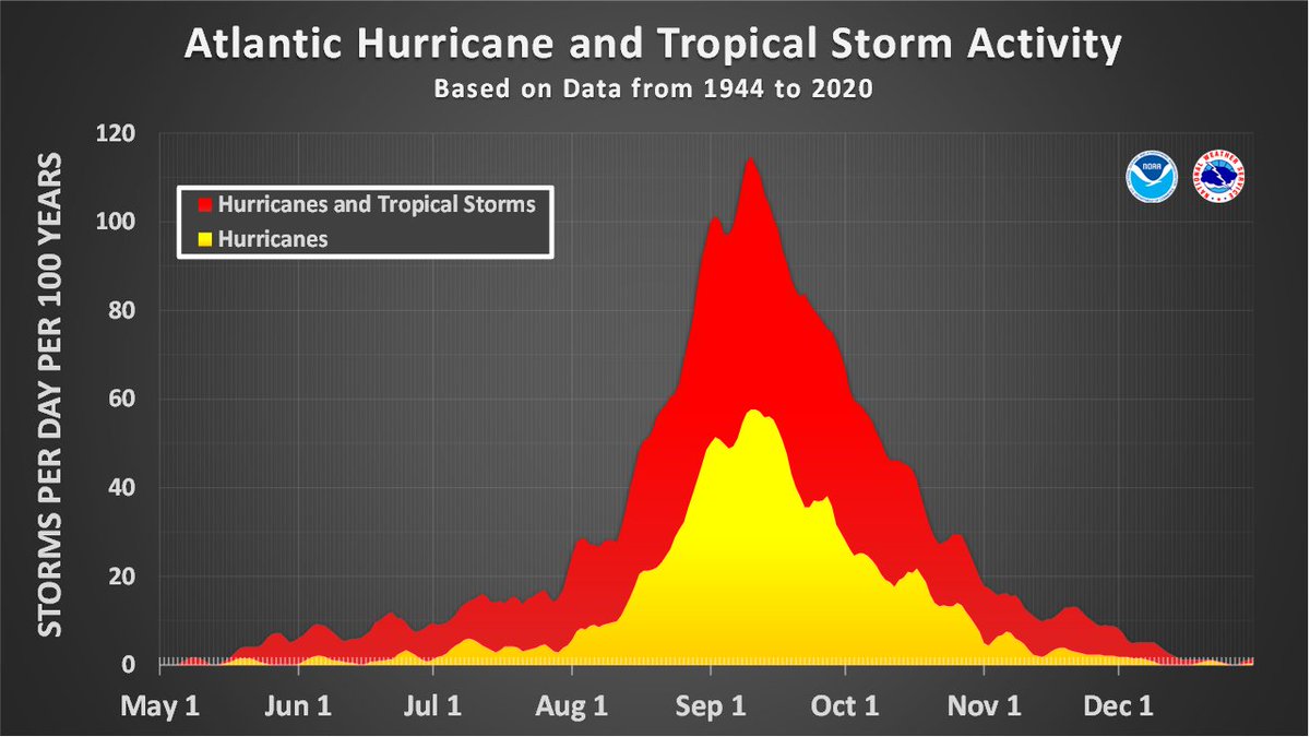
ICYMI: The updated NOAA Atlantic Hurricane Season outlook is that the May prediction remains on track for above-normal Atlantic hurricane season. On average, nearly 80% of all named storms in the Atlantic occur after August 14, so we have a long way to go. Prepare now. https://t.co/W1lAEpNht7
The threat for locally heavy rainfall and intense rainfall rates continues today. A Flood Watch is in effect for the Piedmont and I-95 corridor. Additionally, there is a Marginal Risk for damaging thunderstorm wind gusts this afternoon and evening.
An Excessive Heat Warning remains in effect (excluding the MD beaches and northern Outer Banks, which are under a Heat Advisory). Today will be the hottest day of the week, with heat indices forecast to reach 110° or higher. Ensure you take safety precautions if outside!
Winter Storm Watches are in effect for portions of our area for Sunday evening -Tuesday morning. While there is still uncertainty in exact snow/ice amounts, confidence is high that travel will be impacted. Please stay up to date on the latest forecast at https://t.co/gARrQONn4C
Steep pressure gradient results in strong winds ahead of and behind a cold front tonight through Thursday. A Wind Advisory has been issued for the Eastern Shore on Thursday. Wind chills drop into the teens Thursday night into Friday #mdwx#vawx#ncwx
Several roads in Jackson Ward will close through the weekend for the Second Street Festival. 🌃
Parking will be prohibited
All roads will re-open at approximately midnight on Sunday, October 6.
For towing inquiries please contact Seiberts Towing 804-233-5757.
Run Richmond 16.19, a cultural running event, will bring changes to traffic with numerous road closures and “No Parking” zones in effect on Saturday, September 21, resulting in vehicles on the course being towed.
For towing inquires please contact Seiberts Towing (804) 233-5757
Still keeping a close eye on Potential Tropical Cyclone Eight. Regardless if this system develops into a Tropical storm or not, locally heavy rainfall, minor coastal flooding, high surf and rip currents, and gusty onshore winds will be possible later today into Tuesday.
11pm EDT 9/15 Key Messages on Potential Tropical Cyclone #Eight: Tropical storm conditions are expected through tomorrow night for portions of coastal South & North Carolina, along with the possibility of flash flooding from heavy rainfall
More: https://t.co/tW4KeGe9uJ
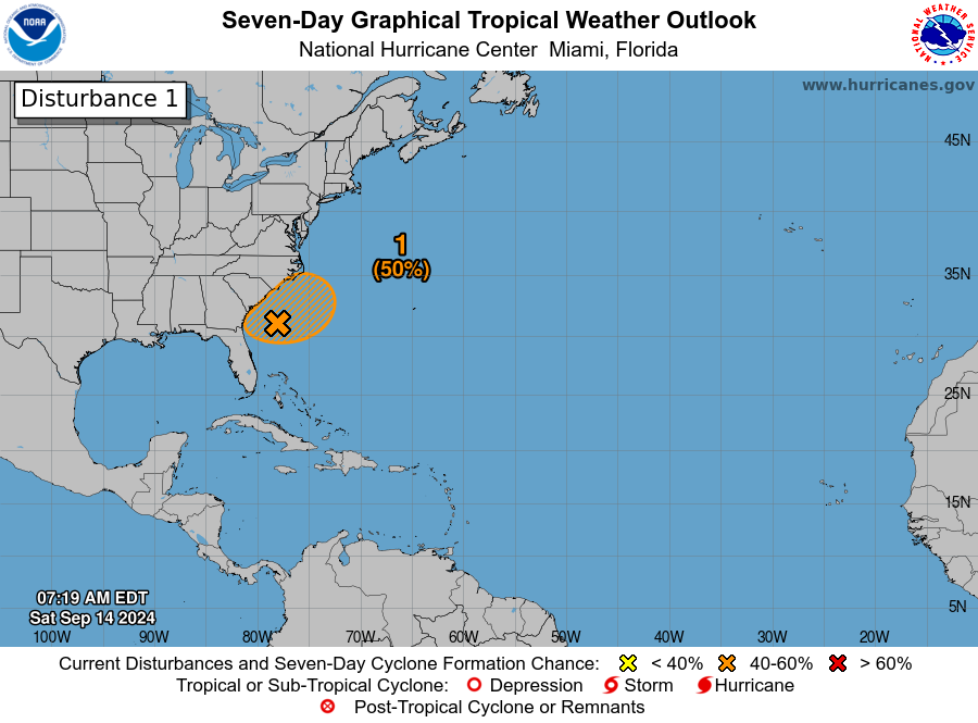
8AM EDT Sep 14: We continue to monitor an area offshore the southeast U.S. coast, this disturbance has a medium chance (50%) for subtropical or tropical development early next week. Stay up to date through the weekend into early next week at https://t.co/tW4KeGe9uJ