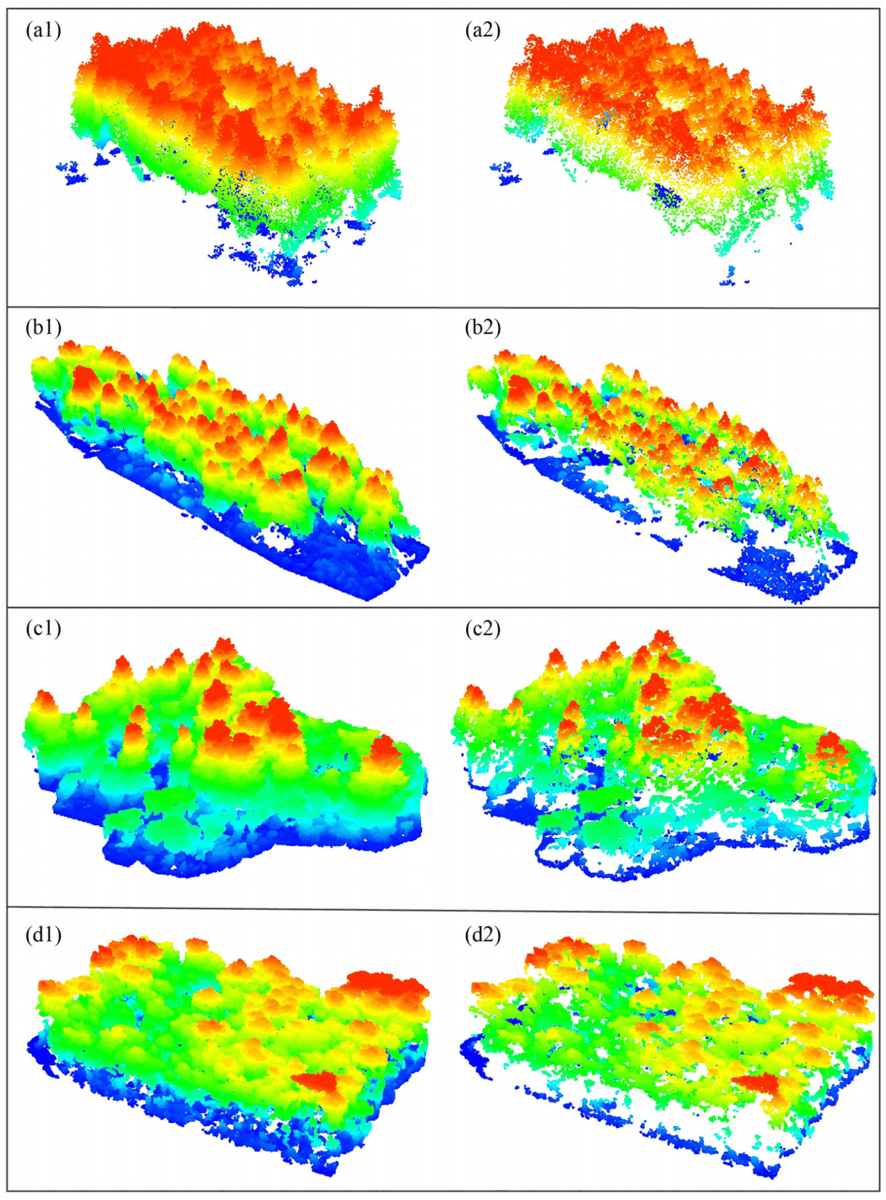
🌳🌲 Individual #Tree#Segmentation Based on #Seed Points Detected by an Adaptive #Crown Shaped Algorithm Using #UAV- #LiDAR Data
✍️ Jiao Yu et al.
🔗 https://t.co/oucPNmydIO
NASA's satellite tech is revolutionizing crop monitoring! At the World Agri-tech Innovation Summit, NASA Harvest showcased how satellites help analyze crop growth, weather patterns, & food security worldwide.
🔗https://t.co/KmQLRALp2j
Coding games are the best way to learn coding.
Improve your skills in Master CSS, Python, React, JavaScript, and Blockchain by playing fun games.
Top 10 Robot Game for Learning Programming Concepts: 👇
On #MothersDay and every other day, the Landsat community celebrates #VirginiaNorwood for pioneering work in the field of #RemoteSensing. The Mother of #Landsat was a brilliant mathematical physicist and aerospace engineer. Learn more here: https://t.co/L4iKZCf0aK
@ElnazNeinavaz@NRS_ITC@ruixie_rs @FacultyITC @DarvishRoshanak Wow amazing. Hopefully in two years I can continue my PhD at ITC. A pleasant learning atmosphere, and knowledge that is in line with my previous master's at the Faculty of Geography, UGM - Indonesia
#Postdoc position in Microwave Remote Sensing of Vegetation @tudelft@TUDelft_CT
⏳Deadline: 5 May 2024
📍Location: Delft, the Netherlands 🇳🇱
💶 Salary: €3226—€5090 per month
Job description:
You will be part of a team of 2 #PhD students and 2 #Postdocs who will combine ground-based experimental data, satellite data, radiative transfer modeling, vegetation modeling and data science to:
- Establish an international network of ground-based GNSS sensors to provide continuous microwave observations of vegetated ecosystems.
- Improve fundamental understanding of microwave interactions with vegetation
- Address the challenge of disentangling contributions from internal and surface water, geometry and other effects that can become increasingly relevant and inter-connected at sub-daily scales.
- Inform, and contribute to the design of a sub-daily radar satellite mission
- Develop modeling and retrieval techniques to capture sub-daily signature of vegetation health.
- Translate insights gained to the exploitation of current radar satellite missions.
For more details and how to apply, check the link ⬇️
https://t.co/AE1dWeHg64
#ResearchJobs #AcademicJobs #ScienceJobs #AcademicTwitter
The biggest threat to tropical forests is not climate change. It is cutting them down.
This @MongabayLatam analysis by Tim Killeen tells us why we are losing the last connections between the Amazon and the Andes.
🎉Excited to announce that I'll be presenting on Climate Risk Assessment using Google Earth Engine, inspired by my work with @WorldBank! 🌍🛰️ Stay tuned! #ClimateRisk#GEE
My work can be found 👉https://t.co/VyfrxHAzIc
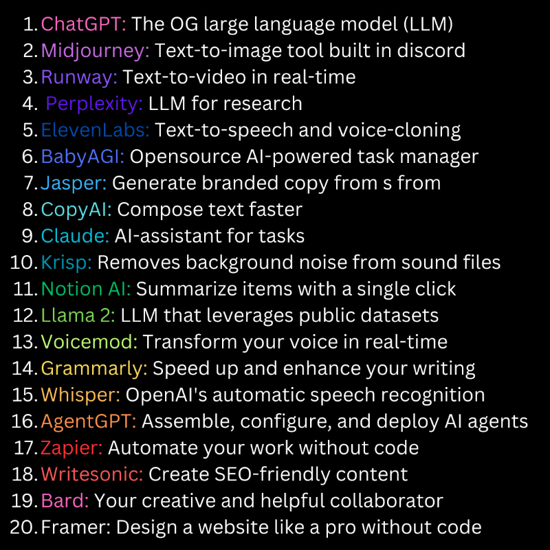
We spend all week researching the top AI tools so you don't have to...
Get insights, tools, and news for free when you join our community of 150,000+ readers.
Click the image below to subscribe for free 👇
🚨 💥🔥
[[BERSIAPLAH! KAMI MENDEKAT]]
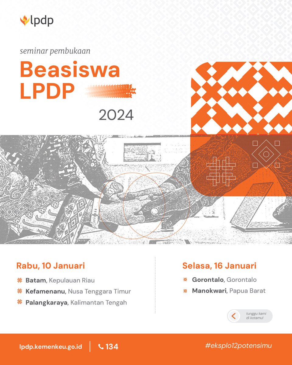
Beasiswa LPDP Tahap 1 Tahun 2024 Siap Dibuka!
Dalam semangat menggaungkan layanan Beasiswa LPDP hingga ke pelosok negeri, kami hadir lebih dekat di kotamu! Yuk ikuti:
SEMINAR PEMBUKAAN BEASISWA LPDP 2024
#DiriUntukNegeri
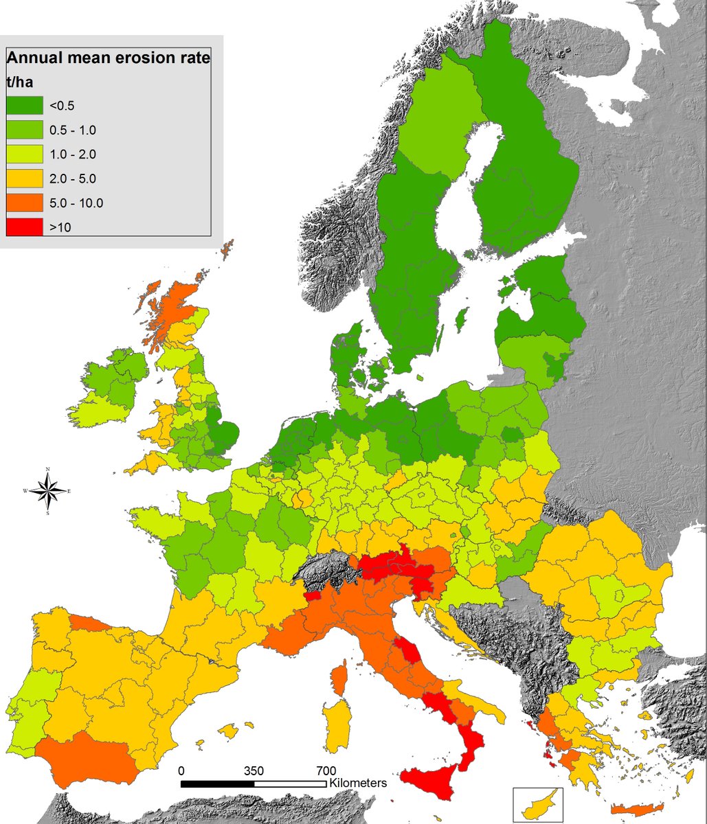
Top 10 most popular Soil Indicators stats of the year!🎉📊. Mean EU🇪🇺 soil loss by water erosion: 2.4 tons per ha per year.
IT🇮🇹: 8.5
SI🇸🇮: 7.5
AT🇦🇹:7
MT🇲🇹:4.5
EL🇬🇷:4
ES🇪🇸:4
CY🇨🇾:3
RO🇷🇴 2.8 ............
More here: https://t.co/ddXxIm6FG8 https://t.co/FZAebfxFVm
Selamat Hari Sumpah Pemuda, khususnya bagi generasi muda ASN dari Aceh sampai Papua 🙌
Mari kita rawat semangat persatuan nasional dan memaksimalkan peran kita untuk kemajuan Bangsa.
#SatuDataASN#ASNNetral
With dryer conditions made worse by El Niño, Indonesia has experienced the return of intense, smoky fires.
Infrared-color #Landsat images show burn scars near Banjarbaru, the capital city of South Kalimantan, and the extent of affected land.
https://t.co/3vZc0WCKaZ