🛰️ What if you could ask: has anything changed here? about any place on Earth & get instant answer?
Using the same radar method @Bellingcat used to map damage in #Ukraine, #Gaza and #Iran , I built #QGIS plugin for anyone to run at home & detect changes anywhere!
#osint#geoint
Two tankers in the Strait of Hormuz, tracked start to finish with free tools.
MarineTraffic, VesselFinder, Equasis, Sentinel-2 imagery. @BenDoBrown shows the whole workflow. 🎯
🔗 https://t.co/fVcomAI22n
#OSINT
Mixed responses to this notice from Google around the ending of GE Pro desktop downloads.
It feels like it has been a long time coming. Over the past few years more and more features have been copied to the browser edition and more updates were going to the browser version than the desktop one. Given that, the GE's browser version now has the same main capabilities: historical imagery, KMZ storage, measurements etc.
Some concerns remain valid, such as uploading sensitive KMLs and KMZs onto a browser-based platform, given GE Pro desktop was locally stored. And the possibility of subscriptions, or 'paid features', making it a commercially viable product. GE browser edition already has a 'standard', 'professional' and 'professional advanced' tier system with the additions being specialised data layers, modelling data layers and gemini/automation integrations.
For the analysts out there, you'll already know of the alternatives. But here's two good free desktop tools to start checking out, in combination with the imagery streamed through Google Earth:
- @qgis which has been around for a while, but self-hosted with streaming integrations and a great community of devs creating new plugins and workflows. https://t.co/k5MrXL5J7A
- GeoLibre by @giswqs which is a new open sourced project with a promising future (both web-based for the less technically-inclined and open sourced) https://t.co/v5U4WIKrCC (video below is a demo of it)
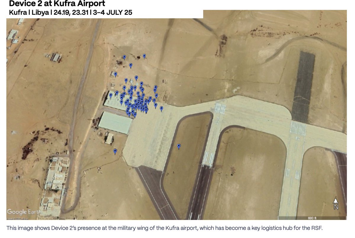
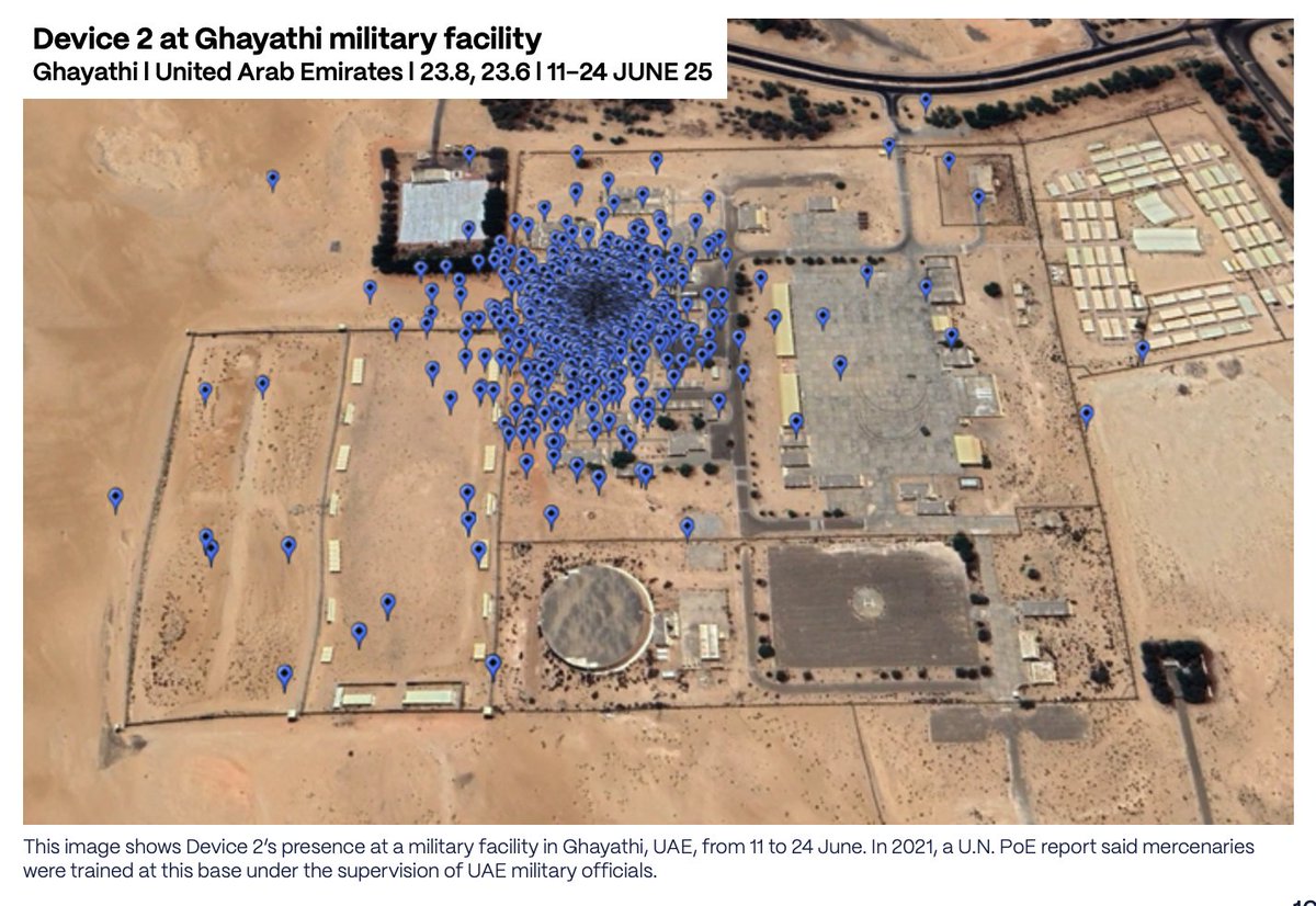
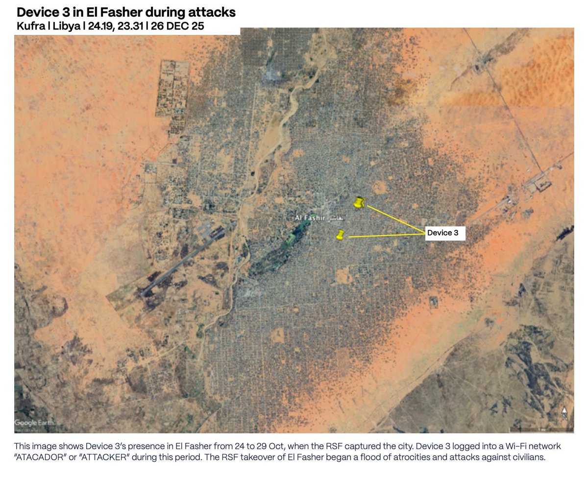
New investigation shows how Libya has become a weapons trafficking and training hub for the RSF, who are committing horrific acts in Sudan, with the backing of the UAE.
Extremely important work by @JCSteers@LHreports@sudanwarmonitor and Evident Media.
A single Strava run once gave away the position of an aircraft carrier.
With 195M+ users, Strava is one of the largest public location datasets online.
So here's a new tutorial on how to find locations on Strava, and the settings that keep your own profile private. 👇
Ever found a Google #Map full of useful locations but no way to get the data out?
I built a tool that exports any public Google Map to KML, KMZ, or GeoJSON + placemarks & icons.
You can run it using Python or just from your browser.
🗺️ https://t.co/rArmpHDwyC
#OSINT#GEOINT
When someone publishes a Google Map of incidents, locations, or field data — you can now pull the whole thing into #QGIS or Google Earth in seconds.
Preserves layers, names, descriptions, and icons. Works offline too if you save the page first.
#OSINT#GEOINT
Calling all #OSINT investigators and journalists!
@FNFreiheit Global Innovation Hub has launched a competition to showcase the power of #OSINT.
Winning project proposals will receive research grant of €7,000 and up to €3,000 for data/tool procurement expenses.
𝗙𝗼𝗿 𝘁𝗵𝗲 𝗳𝗶𝗿𝘀𝘁 𝘁𝗶𝗺𝗲 𝗶𝗻 𝗵𝗶𝘀𝘁𝗼𝗿𝘆, 𝗮𝗴𝗿𝗶𝗰𝘂𝗹𝘁𝘂𝗿𝗮𝗹 𝗳𝗶𝗲𝗹𝗱 𝗯𝗼𝘂𝗻𝗱𝗮𝗿𝗶𝗲𝘀 𝗵𝗮𝘃𝗲 𝗯𝗲𝗲𝗻 𝗺𝗮𝗽𝗽𝗲𝗱 𝗮𝘁 𝗴𝗹𝗼𝗯𝗮𝗹 𝘀𝗰𝗮𝗹𝗲.
I've been collaborating with the Fields of the World (FTW) organization for over a year through Taylor Geospatial and it's finally released publicly in cloud storage for anyone to use, at no cost.
🚢 Just watched @wondersmith_rae crush it on @davidbombal’s channel — teaching exactly how to track “dark ships” & shadow fleets using OSINT (AIS tricks, identity changes & all). Pure gold for anyone into maritime intel.
Must-watch: https://t.co/KFisB7bZXy
#OSINT#MaritimeOSINT
Devices carried by Colombian mercenaries were tracked moving from Colombia to Sudan, via UAE, Somalia, Chad and Libya, placing them in El Fasher during the RSF's violent takeover last October.
New report from @just1nlynch at CIG shows how they got there and what they did.
🛰️ What if you could ask: has anything changed here? about any place on Earth & get instant answer?
Using the same radar method @Bellingcat used to map damage in #Ukraine, #Gaza and #Iran , I built #QGIS plugin for anyone to run at home & detect changes anywhere!
#osint#geoint