Not gonna lie, seeing the TIV and Dominator getting a direct intercept of a tornado and then Daniel Shaw's insane intercept yesterday just reminded me of why I love this hobby so much. I literally felt like a kid again
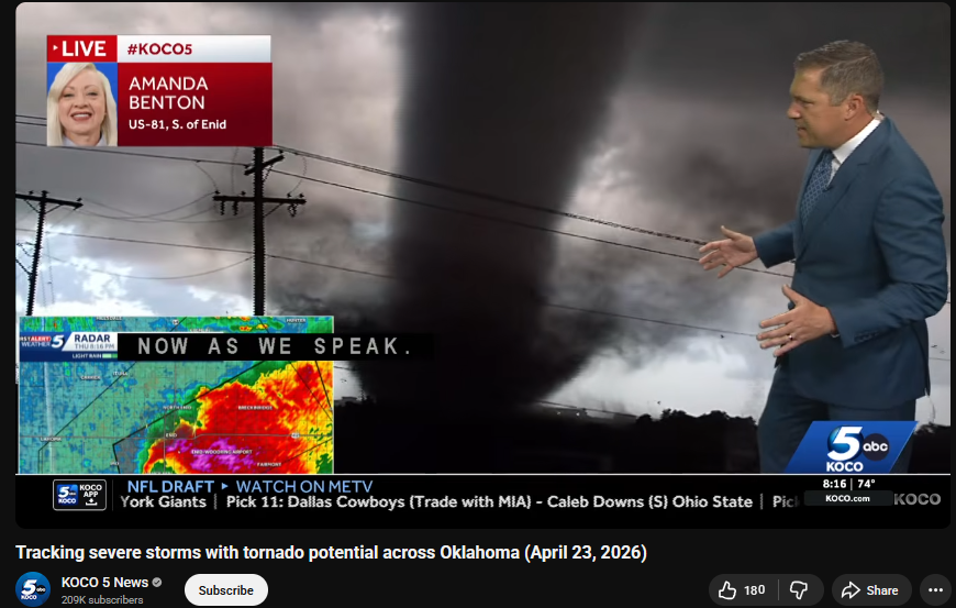
🚨#BREAKING: Watch as twin tornadoes emerge from an extremely large, life-threatening tornado currently on the ground
📌#Braman | #oklahoma
At this time, the National Weather Service has issued a Particularly Dangerous Situation (PDS) Tornado Warning for northern Oklahoma. A confirmed, life-threatening tornado is on the ground, with reports of twin tornadoes actively causing damage near Braman, Oklahoma. This is an extremely rare and serious designation, indicating a high risk of catastrophic destruction. Authorities warn that this is a large and extremely dangerous tornado capable of devastating impacts. If you are in the affected area, TAKE SHELTER IMMEDIATELY. Move to a basement or an interior room on the lowest floor of a sturdy building, away from windows. This is a rapidly evolving and highly dangerous situation.
Here’s the best close range view of the Union City, Mi tornado on March 6th. This capture shows the birth of the twister then into a barrel shape wedge. 😳🙏 #miwx#wxtwitter#tornado
🎥 Credit: Michael Taylor Stewart via Facebook: https://t.co/BZuk9GWfHM
One of the more impressive tornado videos we've received in my time here. This from TJ Second in Union City. Looks like a strong, multi-vortex tornado. #MIWx@wwmtnews@NWSIWX
A thread of videos from today’s flight into Hurricane Melissa
In this first one we are entering from the southeast just after sunrise and the bright arc on the far northwest eye wall is the light just beginning to make it over the top from behind us.
I’ve never seen anything like this in the Atlantic. A CATEGORY 5 monster buzzsaw almost sitting in place as she slowly gets stronger and stronger. Displaying a cryovolcanic CDO that’s ruffled with gravity waves and holding on to perfect symmetry for HOURS on end. This is already upper-tier even if her winds are just 160 MPH. It is insane. There’s just no other way to describe it. And the fact that Jamaica is going to get hit by this, by this Hurricane that is breaking the scales of satellite presentations for Atlantic cyclones, is nothing short of blood-chilling.
Please heed the urgent advice from the NHC and all orders from officials. Melissa is something out of the West Pacific when it comes to how intense her core convection is, and she may not even be done intensifying yet.
For the 3rd time this year, I'm watching the sun rise on a major hurricane making a run at category 5. This one will be the most destructive unfortunately.
Hoping everyone in Jamaica, Haiti, eastern Cuba & Bahamas, and Turks & Caicos has received adequate information on Melissa.
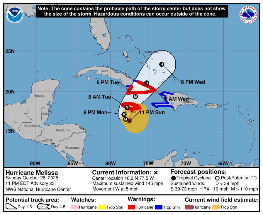
Major Hurricane #Melissa Advisory 23:
No change in the intensity from 22A this evening, still a powerful Category 4 Hurricane with winds of 145mph and a pressure of 933mb. Satellite imagery reveals a much colder and much more symmetrical CDO around the eye, which indicates that Melissa may not have peaked just yet, and further intensification may occur tonight.
A Category 5 landfall remains in the forecast in Jamaica Tuesday morning.
Key Messages:
1. Jamaica: Seek shelter now. Damaging winds and heavy rainfall
tonight and Monday will cause catastrophic and life-threatening
flash flooding and numerous landslides before potentially
devastating winds arrive Monday night and Tuesday morning.
Extensive infrastructural damage, long-duration power and
communication outages, and isolation of communities are expected.
Life-threatening storm surge and damaging waves are expected along
portions of the southern coast Monday night and Tuesday morning.
2. Haiti and the Dominican Republic: Catastrophic and
life-threatening flash flooding and landslides are expected across
southwestern Haiti and southern portions of the Dominican Republic
through midweek. In Haiti, extensive infrastructural damage and
isolation of communities are likely. Although winds have temporarily
decreased on the Tiburon peninsula, they are likely to increase
again across much of western Haiti on Tuesday.
3. Eastern Cuba: Life-threatening storm surge is expected along
portions of the southern coast of eastern Cuba late Tuesday and
Tuesday night. Damaging winds and heavy rainfall with
life-threatening and potentially catastrophic flash flooding and
landslides are also expected beginning on Monday. Preparations
should be rushed to completion.
4. Southeast Bahamas and the Turks and Caicos: Monitor Melissa
closely. There is an increasing risk of a significant storm surge,
damaging winds, and heavy rainfall Tuesday and Wednesday. Watches
will likely be required early Monday.
Here's a closer look at the MCV from KMVX. You can see the peak of the extreme winds, with 100-110mph winds in Eastern ND & Western MN.
This is one of the strongest MCVs recorded in recent history.
⛈️ The storm I witnessed yesterday near Clarendon, Texas, is hands down one of the most incredible ones I’ve ever seen! Those bright blue bands were so vibrant. I haven’t seen such bright blue banding like that since a hail storm in Iowa in 2022.
The blue hues are caused by the scattering of sunlight by ice crystals and water droplets high in the storm clouds, especially during the “golden hour” when the sun’s angle enhances those vibrant colors. I’d trade nearly any tornado I’ve seen in the past two years for this—honestly, I could care less about tornadoes. I just want to see the coolest or most interesting thing out there.
I wish I had more time to stand under this thing.
@RadarOmega@stsweathereye