Il est désormais attendu 42 à 45°C de la Bretagne (!!) jusqu'aux Pays de la Loire mercredi, avec des rafales pouvant atteindre 50 km/h et une humidité relative inférieure à 10 %.
Dans ces conditions, il apparaît de plus en plus probable qu'un épisode majeur de Heat Wave Flash Drought (HWFD) (plus connu du grand public sous le nom d'« effet sèche-cheveux » ou de sécheresse éclair) se mette en place sur une superficie immense (carte 1).
L'association d'une chaleur extrême, d'un air exceptionnellement sec et d'un vent soutenu provoque une accélération brutale de l'évapotranspiration et du dessèchement de la végétation. Les conséquences peuvent être très rapides : pertes foliaires massives, mortalité de jeunes plants particulièrement sensibles, stress sévère pour la faune et l'élevage, et risque d'incendie atteignant des niveaux extrêmes à très extrêmes (carte 2).
L'ampleur des valeurs envisagées pour l'ouest de la France est difficile à appréhender. Voir de telles conditions s'étendre jusqu'à la Bretagne est tout simplement stupéfiant. En tant qu'agroclimatologue, je suis profondément sidéré par ce que les modèles continuent de simuler.
Nature on death row
Arizona reservoir nearly vanishes after snowpack collapse triggers massive fish kill
A historic lack of snow in the Gila River watershed has left Arizona’s San Carlos Reservoir less than 1% full
https://t.co/NRvIlXFTwr
--- Jakobshavn Glacier ---
We simply have to take this seriously. Without a doubt. Greenland as a robust whole is at risk. And we will bear the consequences of this in every country on our planet within this decade.
A hundred years ago, the eastern bluebird was one of the most common birds in the country. Then it nearly disappeared.
Here's the problem: a bluebird can't build its own home. Neither can a chickadee or a wren. They're cavity nesters with no tools to dig a hole, so they move into ones that already exist: an old woodpecker hole, a rotted knot in a tree, a hollow in a dead limb, a soft spot in a wooden fence post.
Then we launched a relentless effort to tidy the world and put everything in its right place.
We cut down the dead trees, the "ugly" snags, and hauled them off. We swapped the old wooden fence posts for metal. We cleaned up every hollow stump and dying branch. And just like that, the nesting spots were gone.
Worse, two birds we'd imported from Europe, house sparrows and starlings, muscled into the few cavities left and threw the bluebirds out. By the 1970s, bluebird numbers had fallen by nearly 90%.
Here's where things began to turn. Ordinary people started nailing wooden boxes to posts. Just boxes, with a hole the right size. And the bluebirds came back, all the way back, one of the greatest comebacks in American conservation, built almost entirely by regular folks in their own yards with a little lumber.
So here's where you come in. A nest box isn't a cute decoration. It's a replacement for the dead tree we took down, a hole in the world for a bird that can't make its own.
Put one up, with the correct hole size for the bird you want, on a smooth pole a predator can't climb, and you stop being a bystander to that story.
🚨Hard to overstate how ominous this looks.
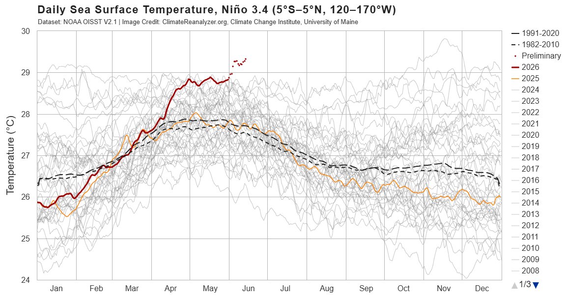
Niño 3.4 SSTs are already at 29.27°C by June 13, with daily records being obliterated across early/mid June.
El Niño is a natural phenomenon. But this is now unfolding on top of a human-warmed ocean background — and that extra heat is helping push the system into record territory.
Scientists stunned by massive brown ribbon stretching across Atlantic from Africa
A 37.5 million tons of pelagic sargassum, a species of brown seaweed, forming an unbroken band from the coast of West Africa to Gulf of Mexico. This Atlantic Great Sargassum Belt simply did not exist 15 years ago.
https://t.co/L3PPMtAgZd
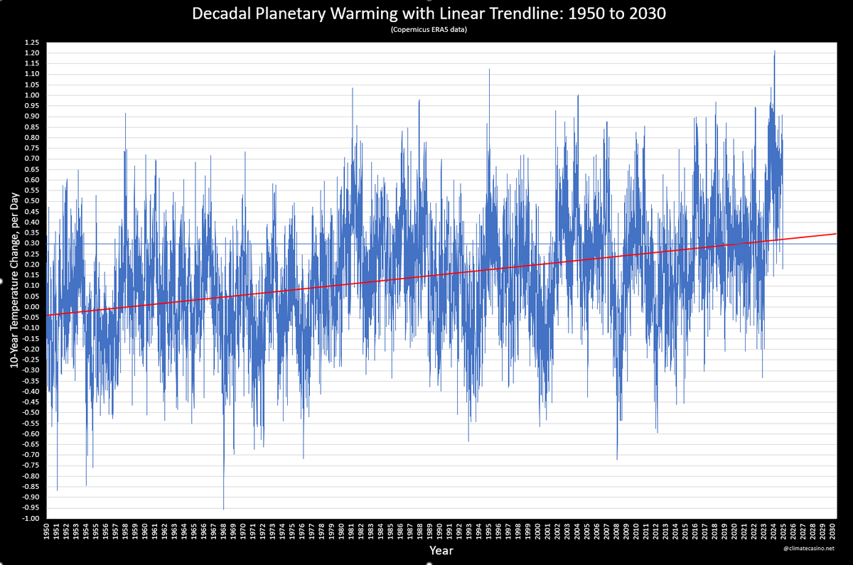
Take the difference in temperature for each day, January 1, 1950 through June 13, 2026, from the exact same day 10 years earlier, to get a "daily decadal temperature difference." Graph those points with a linear trendline.
The current rate of warming is about 0.32°C per decade.
The main reason why we must speak of a special El Niño is the very early launch of early summer warming in the Northern Hemisphere, generated from an already existing high temperature gradient in the upper layers of the oceans.
We know where it starts, but not where it will end.
👀 The 7.8 magnitude earthquake that struck Mindanao caused parts of the seabed to rise by as much as 2 metres and the coastline has reportedly moved out by around 200 metres.
The sudden uplift has exposed coral reefs, seagrass and marine habitats, leaving sea life stranded and causing damage to the underwater ecosystem. Officials found exposed coral and dead marine animals along affected areas.
It’s incredible to think about the force needed to physically lift the seabed out of the ocean like this.
📷 DENR Soccsksargen
🚨 WARNING: The Pacific Ocean is flashing red.
Central equatorial Pacific temperatures have now broken ALL previous records for 5 straight days.
Even more alarming: a powerful record-breaking westerly wind burst is underway RIGHT NOW, adding fuel to an already explosive El Niño.
History shows that when ocean heat reaches extreme levels, the consequences can be devastating:
⚠️ Mega floods
⚠️ Severe droughts
⚠️ Crop failures
⚠️ Water shortages
⚠️ Record-shattering global heat
The last truly extreme El Niño events changed weather patterns across the entire planet.
This one is developing faster than almost anyone expected.
The atmosphere is loading the dice for weather extremes in 2026-27.
The question is no longer whether El Niño is coming.
The question is: How extreme will it become?
🌎🌡️🚨
🚨 BREAKING: The Pacific is flashing a warning sign.
NASA satellites are detecting a massive sea-level rise across the tropical Pacific as a rapidly strengthening Super El Niño takes shape.
🌊 Warmer oceans = expanding water
🌧️ Extreme rainfall in some regions
☀️ Severe drought in others
🌾 Global crop production at risk
If current forecasts verify, late 2026 into 2027 could bring:
⚠️ Historic flooding
⚠️ Agricultural disruptions
⚠️ Food price spikes
⚠️ Weather extremes on a global scale
The climate system is loading the dice once again.
How strong do you think this El Niño will become? 👀
#ElNino #ClimateCrisis #Floods #ExtremeWeather #FoodSecurity #ClimateEmergency 🌎🌡️🌊
Hold on to your rice paddies, NASA satellites are detecting a major sea-level rise across the tropical Pacific as the Super El Niño rapidly strengthens. If forecasts verify, late 2026 /2027 will see extreme floods and crops impacted. The climate system is sending another warning.
China warned communities in its northwestern Xinjiang and nearby regions on Friday to prepare for "extreme floods" this summer, driven by abnormally high temperatures, heavy rainfall, and rapid glacier melt - Reuters
🚨 MJO WATCH: A major atmospheric shift may be underway.
The latest SCORPION methodology + GFS forecast suggests the currently trapped Madden-Julian Oscillation (MJO) could finally break free after mid-June.
🌊 Deep tropical convection is projected to slowly move into the Indian Ocean after June 20.
Why does this matter for India? 🇮🇳
✅ Increased thunderstorm activity
✅ Potential support for monsoon revival/strengthening
✅ Improved rainfall prospects in several regions if the signal sustains
The pace remains slow, and forecasts can change, but this is one of the most important tropical signals to watch over the next 2 weeks.
If the MJO successfully establishes itself over the Indian Ocean, India's weather pattern could look very different heading into late June.
🌧️ Monsoon watchers, are you expecting a stronger second half of June?
#India #Monsoon2026 #MJO #WeatherUpdate #Rainfall #IndianMonsoon #Climate #ElNino
Sorry to bother you today, but here is another alert about Thwaites Glacier during the Antarctic Winter.
Spring Tide?
Deep Ocean Heat?
Ok, that’s all.
Check back tomorrow.
@larry79115@FardouxPierre
Hi guys, this is another private message just for the two of you. Definitely don't share it with anyone.
In these three animations, you can clearly see that the glacier front is accelerating more than the rear guard. This is a very serious development.
The thing is, the El Niño buildup was already established very early in the northern spring, reaching an unusual initial level.
This implies that we can expect midsummer peaks north of 30°N that are unprecedented for both SST & 2m temp.
Our climate system is in murky waters.
@UN
🚨 EL NIÑO HAS OFFICIALLY ARRIVED.
After months of anticipation, NOAA has issued an El Niño Advisory, confirming that El Niño conditions have developed in the tropical Pacific.
And here's the headline everyone is watching:
📈 There is now a 63% chance this event reaches "Very Strong" status by late 2026.
If that happens, the world could be dealing with one of the most powerful El Niño events ever observed.
🌎 Why it matters:
• 75% of the U.S. is currently experiencing dryness or drought
• One year ago, that figure was only 48%
• El Niño typically reshapes global weather patterns, agriculture, water supplies, and energy markets
According to NOAA's outlook:
🌧️ Wetter conditions are favored across the southern U.S.
❄️ A stronger Pacific jet stream could increase storm activity
🔥 Much of the northern U.S. is expected to be warmer than normal
⚠️ The Pacific Northwest and parts of the South remain key drought concern areas
But the implications extend far beyond America.
A strengthening El Niño can impact:
🌾 Global crop production
☕ Coffee and cocoa regions
🌴 Palm oil output
🌧️ Asian monsoons
🔥 Drought and wildfire risks worldwide
What's remarkable is that this event is only beginning, yet many forecast models are already projecting sea surface temperature anomalies exceeding +3°C, with some scenarios approaching +4°C.
The atmosphere is now starting to respond.
The real question is no longer whether El Niño is coming.
It's how strong it becomes — and whether the world is prepared for the consequences.
🌎📈🌧️🔥
#ElNino #Weather #Climate #Drought #Agriculture #NOAA