In Sagaing, Myanmar, earthquake-affected families are rebuilding in safer, climate‑adapted homes; bamboo roofing to reduce heat, raised foundations to protect against flooding, and space to safeguard food for those still facing uncertainty.
With support from the @MyanmarRedCross and the @IFRC, more than 26,000 people have received shelter assistance, as part of a wider response reaching over 200,000 people across 30+ townships.
Each home stands on resilience, rooted in local knowledge.
#Dubai Want to help with fact-checking, or report misinformation? Use @signalert in Arabic to share your report, with a photo, date, time, your description. You’ll see the shared, geotagged alerts on the app. The more people who share, the faster the information is verified.
توضيح: الدخان الملاحظ في منطقة الجداف ناتج عن حريق في قارب متوقف في خور دبي. ولم ينتج عن الحريق اي إصابات، وتعود كثافة الدخان إلى مادة الفيبرجلاس المستخدمة في تصنيع القارب. وتدعو الجهات المعنية الجمهور إلى الحصول على المعلومات من المصادر الرسمية وعدم تداول الشائعات أو المعلومات غير الدقيقة.
Gunung Dukono ini sering erupsi dan rekomendasi dari PVMBG tidak beraktivitas/mendaki dan mendekati Radius 4KM. Tapi tetap banyak yg mendaki.
Namun kali ini erupsi nya besar dan kabarnya puluhan pendaki terjebak (termasuk WNA)
Semoga aman aman aja
I received a #tsunami alert on my smartphone.
What should I do?
Discover how the exposure maps available on our free #earlywarning and crowdmapping app can help you to reach safe places more securely @IocUnesco
https://t.co/v9YXTejnhA
Absolutely mesmerizing to witness the glowing lava fountains at Kīlauea's summit eruption in Hawaiʻi Volcanoes National Park. Volcanoes are living monuments to Earth's fiery origins, a powerful reminder that our planet’s forces are still alive and at work.
Video by @usgs
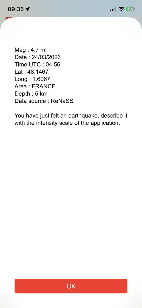
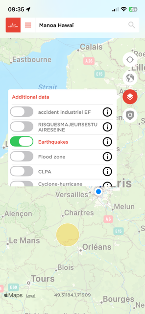
Un #séisme superficiel de magnitude 4.7 ressenti dans la région d'#Orléans#France. Partagez vos descriptions de ressenti ou d'impacts avec l'app @signalert et son échelle de gravité. Suivez les éventuelles répliques sur l'application. @AFPCNT_risques@AFPS10@afpfr
🔊 Este fin de semana, el @IGNSpain ha detectado nuevos movimientos sísmicos en El Teide: durante la madrugada del sábado se registraron un total de 50 terremotos.
@ita_dc aclara que son movimientos distintos a los enjambres.
📻 #InformativosLRC
📡 https://t.co/Rkqwj1b5KO
#Pakistan#Gilgit#Baltistan Whether is accurate or not, this is a processes by which a Glacial Lake Outburst Flood (GLOF) forms. The river will rise until it overflows the dam. To be monitored by satellite imagery. It's a pitty that site cannot be located using @signalert app.
العنوان: بالفيديو.. انهيار جليدي مرعب في شمال باكستان يستقطب أنظار السكان 🚨
باكستان – جيلجيت بلتستان:
وثقت مقاطع فيديو متداولة لحظة وقوع انهيار جليدي ضخم في إحدى المناطق الجبلية الوعرة شمال باكستان. وأظهر المقطع اندفاعاً هائلاً لكتل من الثلج والمياه المختلطة بالصخور، وهي تنحدر بسرعة فائقة من القمم الشاهقة باتجاه الوادي.
#pakistan #Avalanche🚨
Terrifying memory of that day 11th March 2011 of the #Tohoku#tsunami in #Japan a reminder that very low probability events, sometime recorded in human history, can happen anytime. A wake up call with the Dec. 2004 Indian Ocean Tsunami & the Feb. 2010 South Chile tsunami.
🧵 Today marks 15 years since the magnitude 9.1 Great East Japan earthquake struck off the northeast coast of Honshu on 11 March 2011. One of the most powerful earthquakes ever recorded. 1/4
cette vidéo du #tsunami de #Tohoku au #Japon illustre bien comment et pourquoi certaines catégories de personnes sont plus exposées, plus vulnérables lors de catastrophes majeures, même avec l'un système d'alerte précoce les plus performants du monde #EW4ALL
Il y a 15 ans, la région de #Tohoku#Japon était frappée par un des plus forts séismes historiques mesurés, source du #tsunami qui frappa la centrale de #Fukushima Daïchi. Lisez le retour d'expérience auquel j'ai participé pour l'@AFPS10
https://t.co/XhYZzSzivk @AFPCNT_risques
Il y a 15 ans, la région de #Tohoku#Japon était frappée par un des plus forts séismes historiques mesurés, source du #tsunami qui frappa la centrale de #Fukushima Daïchi. Lisez le retour d'expérience auquel j'ai participé pour l'@AFPS10
https://t.co/XhYZzSzivk @AFPCNT_risques
Il y a 15 ans, le 11 mars 2011 à 14h46 avait lieu le grand séisme du Tohoku qui provoqua un tsunami dévastateur.
Un bilan de 22 318 morts et de 6242 blessés.
Des gens ce jour-là ont perdu des enfants, des parents et des frères et sœurs #RIP#Japon
Kīlauea episode 43 of lava fountaining at the summit, within Hawai’i Volcanoes National Park continues at this time.
The lava fountain from the south vent has decreased to around 1000 feet (300 meters) high and the lava fountain from the north vent is 700 feet (200 meters) high. Tephra fall to the north and east has greatly reduced in the past hour. Fine ash and Pele’s hair has been reported falling as far as Hilo and Hawaiian Paradise Park.
Help support science and community awareness by submitting a tephra fall report at: https://t.co/jKpA1sk7Zx
The National Weather Service has issued an Ashfall Warning for the region around Kīlauea summit and an Ashfall Advisory for the communities to the east.
Hawaii County Civil Defense Agency announced the closure of Highway 11 between the 24 and 40 mile markers due to dangerous conditions being created by tephra falling.
Hawai’i Volcanoes National Park has announced that temporary closures around Kīlauea summit are in place due to volcanic hazards. Lodging guests of Volcano House and Kilauea Military Camp will be allowed to enter the park.
🎥 Video of episode 43 fountaining and eruptive plume on March 10, 2026. Tephra clast that landed in National Park, and Pele’s hair/ash in Hilo.
#Kilauea #hazards #ash
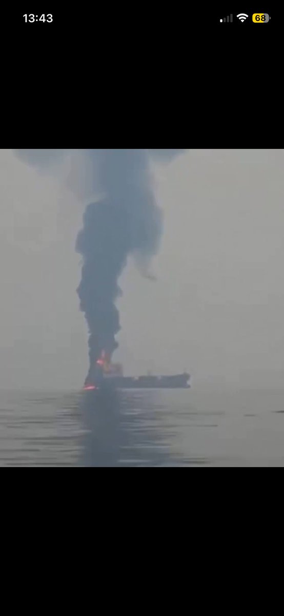
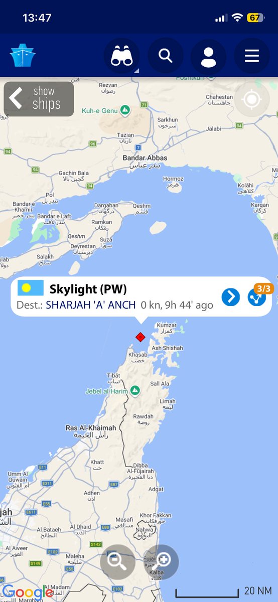
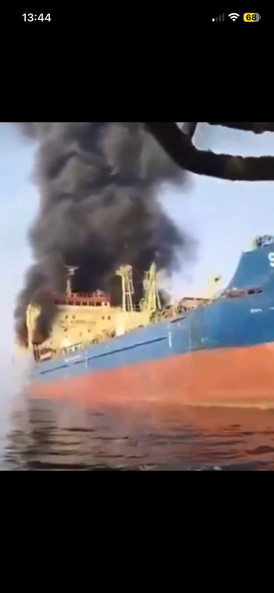
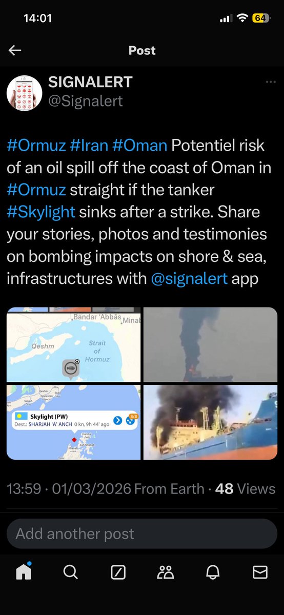
#Ormuz#Iran#Oman Potentiel risk of an oil spill off the coast of Oman in #Ormuz strait if the tanker #Skylight sinks after a strike. Share your stories, photos and testimonies on bombing impacts on shore & sea, infrastructures with @signalert app
#avalanche Lorsqu’on est confronté pour la première fois à un évènement catastrophique, la sidération prévaut souvent et décale ou inhibe les réactions de sauvegarde.
L’app @signalert propose des conseils de comportement à lire avant. Reportez les impacts avec l’application.
Avalanches : impressionnante avalanche à Val Veny, dans les Alpes italiennes près de la frontière française, où trois skieurs français sont morts.
Aujourd'hui, deux skieurs sont morts à La Grave dans les Hautes-Alpes et un promeneur décédé emporté par une vaste plaque de neige dans la station de Valloire, en Savoie.
Depuis le début de la saison, 28 personnes ont perdu la vie dans des avalanches en France, dont 6 lors d’un week-end noir les 10-11 janvier.
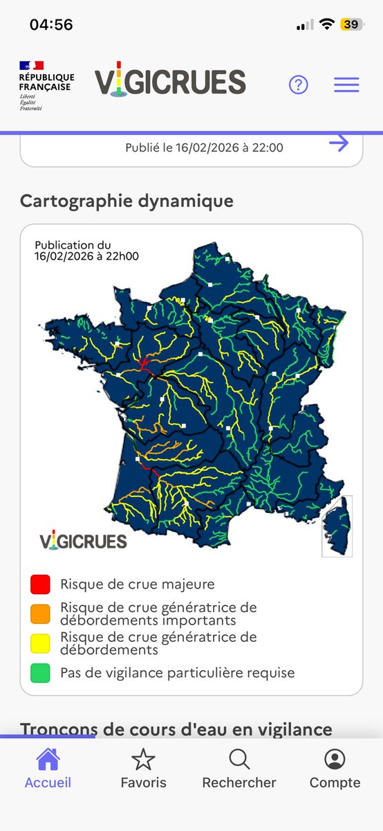
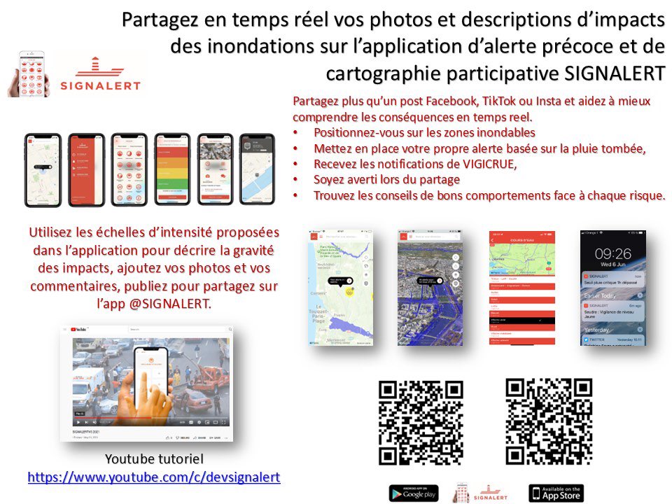
Un carte de #France largement inondée rarement vue depuis la création de la #vigilance. Pour reporter les #inondations sur les secteurs non surveillés par @Vigicrues témoignez en partageant des alertes inondation avec l’application @signalert.
🔴 Savoie : Vigilance rouge avalanches
De très grandes avalanches pourraient se produire et atteindre des routes, des infrastructures, voire des habitations.
➡️ Plus d’informations dans le bulletin https://t.co/SBcDaJ44jS
🚨⛈️ ALERTE INONDATIONS À #ANTIBES/#VALLAURIS(06). Le violent orage stationnaire provoque d’énormes ruissellements en ville. Résultat, des parkings souterrains sont déjà inondés, comme le montre cette vidéo partagée par Thierry Andréa depuis le secteur de #Vallauris(06). #Nice06