We're excited to announce that VertiGIS has been selected as a recipient of a 2021 Esri IMGIS Conference Partner Award! This award recognizes the excellence of our Utilities alignment solution on Esri's Utility Network. Thank you to @Esri for their partnership and support!
Möchten Sie Ihre Prozesse im Versorgungsmanagement verbessern? Nehmen Sie am 7. September am VertiGIS Utilities Talk teil und erfahren Sie, was mit unseren Software-Lösungen alles möglich ist! Jetzt anmelden --> https://t.co/GNFHl3rTzB
Möchten Sie Ihren Anlagenbestand mit sämtlichen Prüfpflichten organisieren? Mit unserer Maintenance Management Lösung gelingt das im Handumdrehen! Mehr dazu erfahren Sie bei unserem VertiGIS Themenforum im April --> https://t.co/QvQWDm07xt
Wir sind bereit! Die INTERGEO Digital 2020 öffnet morgen Ihre Tore. Wir freuen uns auf Ihren Besuch auf unseren LIVE Messeständen und in unserer LIVE Vortragsreihe https://t.co/hCkHfz6Phy
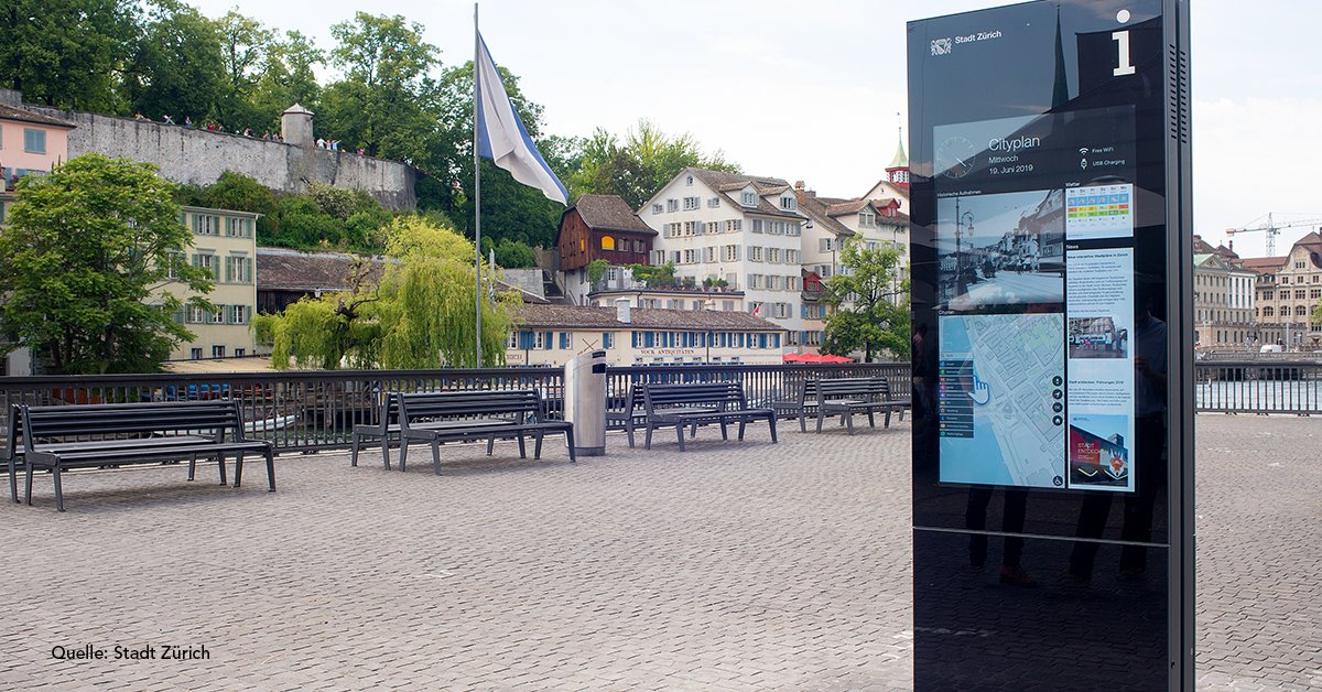
Find out how #VertiGIS eGuide -- a digital signage solution for smart cities -- transforms traditional information panels into interactive digital information systems for cities, airports, shopping malls and other land marks --> https://t.co/Vs7clZyWEF
We integrate the #COVID19 real-time data of the @WHO and @JohnsHopkins University into our #GEONIS#RMBC solution. This allows our customers to achieve the greatest transparency of supply chain failure risks due to the current pandemic --> https://t.co/ui4md56KLr
It's a good day: great system performance, our #UtilityNetwork#GEONIS Report is working, our new #ArcGIS#runtime App GEONIS gear for iOS is also working .... Now it's the perfect moment for weekend :-)
İş Ortağımız olan Geocom firması ile Universal Yazılım Merkez binasında bir hafta süren Esri’nin 2018’in başında açıkladığı yeni Altyapı Ağı Modeli (Utility Network Model) üzerine çalışmalar yapılmıştır. Haberin tamamı için:
https://t.co/xXExyZ6HEy
Zusammen mit der GSG https://t.co/queuoVqjHk betreiben wir ein umfangreiches Netz- und Geographisches Informationssystem auf Basis von #Esri#ArcGIS und #GEONIS für sechs Wasserzweckverbände und drei Abwasserzweckverbände im Raum #Regensburg
Netzinformationssysteme #NIS bilden ein Teil des Digitalen Zwillings innerhalb der #Digitalisierung ab - #HamburgWasser 💦 https://t.co/5lm0XnUllA ist ein modernes Unternehmen und seit vielen Jahren mit #Esri#ArcGIS, #GEONIS und #SAP in der Prozessoptimierung unterwegs.
Auf Basis einer #GIS gestützten Informationsplattform #ArcGIS, #GEONIS werden Betriebsmittelinformationen inklusive räumlicher Daten der #Kraftwerke der LEAG AG durch #Geocom für exzellente Visualisierungen und Analysen als optimale Entscheidungsgrundlage aufbereitet.