Chief Researcher at Institute of Market and Economic&Ecological Researches of the National Academy of Sciences of Ukraine
Prof., Doctor of Science in Geophysics
And there you have it!!! It's the first thing that came to my mind but the 'earthquake' that wasn't an earthquake threw a spanner in the works.
NEPAL FLOOD: Researchers emphasize that this sudden, devastating surge was fueled by climate-driven glacial thinning.
Scientists at Kathmandu University and ICIMOD report that this thinning caused a massive glacier break-off, triggering a 5.2-magnitude seismic event and a flash flood along the Nepal-Tibet border.
Satellite assessments show that the resulting ice and rock avalanche temporarily dammed the Lhende River before bursting downstream
Temperatures in the area of the #Glacier Collapse have been increasing at about 2X the average global warming rate… about 5°F since 1940. While we need further investigation on this particular event, it’s clear glaciers around the World are becoming less stable. A new 2026 study on a nearby glacier found that the rate of glacial area loss increased more than 4X from about 0.11%/yr before 1964 to 0.49%/yr during 1964–2023, with further acceleration after 2000. Paper in thread 🧵 1/
#Nepal #Tibet
Breaking News!
Code: y-Axis alert!
The latest global preliminary sea-surface temperature for August 23rd blew away the previous record set just yesterday. I had to raise the y-axis to accomodate the new record.
Will I have to extend the y-axis again tomorrow? Stay tuned.
Breaking News!
Code: Yikes!
Another record hot day. August 19th was nearly 1.69°C above pre-industrial. The planet has now seen 13 consecutive record daily highs.
The Climate 8-ball is playing in a fountain.
Quick El Niño update.
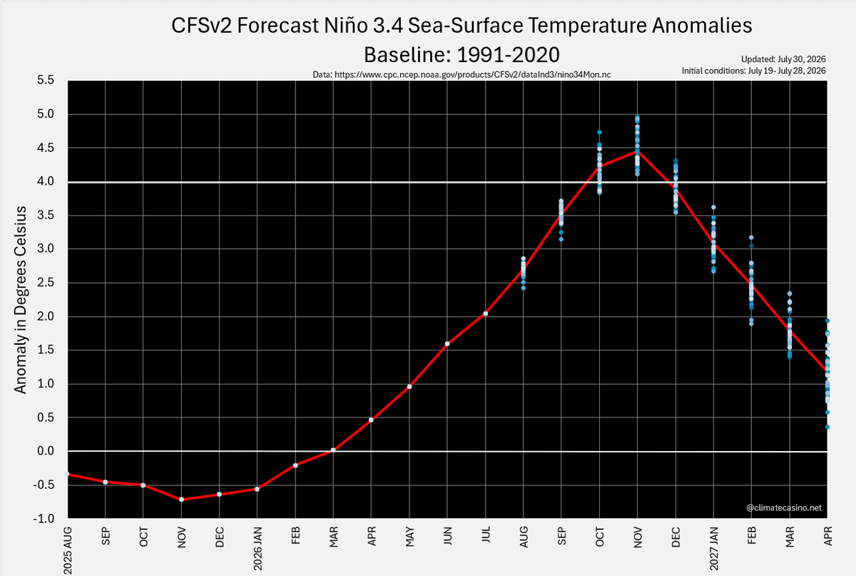
The most recent Niño 3.4 sea-surface temperature for August 17th was 2.73°C above the 1991-2020 average. This marked the 80th consecutive day setting a new record daily high, and was 0.92°C above the previous record for the day set back in 1997.
In order for 2026 to average 1.60°C above pre-industrial, the rest of the year starting today has to average 1.84°C above pre-industrial.
And yet, that's the forecast.
https://t.co/OvkbjXiOot
NEW: Increasingly hot, dry and windy conditions could substantially extend the area affected by wildfires across Europe, according to a new study led by PIK's Maik Billing with contributions from Senckenberg Society for Nature Research.
Read more 👇
https://t.co/FIkPuncG2A
As in life so in politics: it matters knowing what works and what doesn't.
PIK scientist Hannah Heiliger explains how the effects of climate policy can be assessed to continually improve their efficacy.
#EvidenceBasedPolicy#PolicyEvaluation#PublicPolicy#ImpactEvaluation
Breaking News!
Code UFB!!!
August 13, 2026 is now the latest in the year a 17.0°C global temperature has been recorded. Before 2026, the previous record was Aug. 7, 2024.
The speed at which this Godzilla El Nino is taking hold of the global climate cannot be overstated.
European cities are counting on carbon removal to compensate for a fifth of their emissions, but few have thought through how. A new study by @EU_JRC with contributions from PIK makes concrete suggestions for city policymakers to build on existing plans.
https://t.co/XkZeuPWGG2
💧#Drought update in Europe
The latest EDO Low-Flow Index for the third ten-day period of July 2026 shows severe and extreme low-flow along the #Rhine, the #Loire, the #Danube and the #Po, and much of the Alpine and Carpathian drainage network
More: https://t.co/10BknYJtYh
"Es gibt Anzeichen, dass in der Klimawissenschaft die Leute zu vorsichtig waren. Weil sie Angst davor hatten, als alarmistisch eingestuft zu werden. Das war aber nicht alarmistisch, sondern alarmierend. Das ist ein großer Unterschied." @lewan.uk
Stimmt.
https://t.co/k11YYtmIRQ
"India could lose 6.6% of its rice yield for every 1°C rise in global mean temperatures... raising concerns for a country where rice feeds about two-thirds of the population."
New paper on the affects of heat extremes on rice covered in @down2earthindia.
https://t.co/KZ0FBcuIr3
The brand new CanSIPS model run is in, and it has intensified its El Niño forecast yet again.
It now shows a record-breaking El Niño for six months straight, from September to February, peaking just shy of +4˚C in December.
In the latest CFSv2 run for the Nino 3.4 region, there is now no model run that peaks below 4.1°C.
Fortunately, cities and local governments around the world are already preparing for what could be the most significant global climate event in 150 years.
Oh, wait.
El Niño continues to intensify during the August-October 2026 season. Above-normal temperatures are likely across the world. Wetter conditions in some regions and drought risk in others are expected, consistent with a classic, strong El Niño event.
🗞️ https://t.co/056oYaRROn