@ChrisMartzWX "This observed pause in ice loss is simulated relatively frequently (a nearly 20% chance) in climate models, and is thus to be expected even under high emission scenarios."
https://t.co/WVQgbGkjs9
@oldscarf1stweek @WxTca@CPalermo_Storms@GumryWX Sure I read it, and I disagree with your stance, hence my post. I don't understand your condescension towards Deelan and myself here for a difference of opinion over semantics.
@oldscarf1stweek @WxTca@CPalermo_Storms@GumryWX The damage footage from Melissa's immediate landfall location is fully consistent with an intense tornado spread over a large area. Arguing EF-4 winds or not from a semantics standpoint is just meaningless as Deelan originally said.
Wild ride in Hurricane #Melissa today. My first time ever in a Category 5, and it was definitely the most turbulent I've ever experienced. I was processing the dropsonde data and sending it out - some of these are up there with about as strong as Atlantic hurricanes can get. Definitely take this one seriously in Jamaica and Cuba.
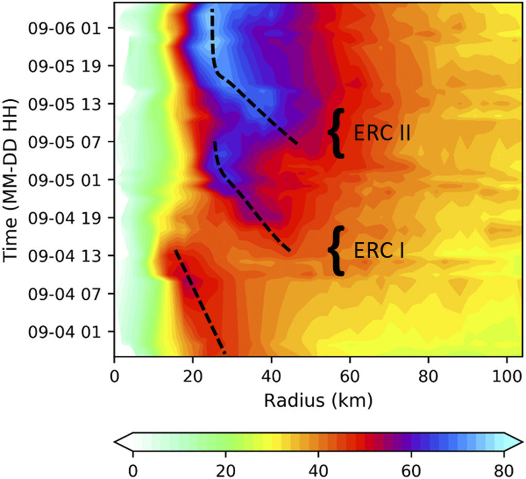
I have been seeing a significant amount of chatter on this “MERC” or merger eyewall replacement cycle and how one is thought to have occurred in Melissa. It’s my understanding this was first documented in Hurricane Irma in this paper I authored: https://t.co/07gLcNhWI8 🧵
On the other side of the tag team, #Humberto is currently facing some moderate westerly wind shear, but this shear is expected to abate and allow for significant strengthening in the coming days. NHC forecast shows no direct threat to land in the next 5 days.
Invest #94L has grown in its potential threat to the Bahamas and US East Coast per EPS/GEFS guidance, but it is prudent to note that its proximity to #Humberto makes track and intensity forecasting of lower than usual confidence. Bahamas and SEUS residents should watch closely.
Hurricane #Gabrielle is rapidly intensifying this morning and appears poised to become the second major hurricane of the season while passing east of #Bermuda.
“Tropical Storm” Gabrielle.
Yesterday, we had a few hours of convection, but no organized rotation around a well-defined center. Today, we have a vortex, but essentially no convection.
This isn’t a tropical storm and arguably it never was.
Sometimes I think the “experts” at the NHC just like to name stuff to boost the numbers for forecast verification given how quiet this season has been, defying expectations.
@_ClimateCraze Hi John, Tonga does not apply to any of my statements, but most evidence indicates that Tonga likely had a cooling (not warming) effect on Earth. See Schoeberl et al. 2024 in JGR Atm and Gupta et al. 2025 in Nature for some recent research on Tonga's impacts.
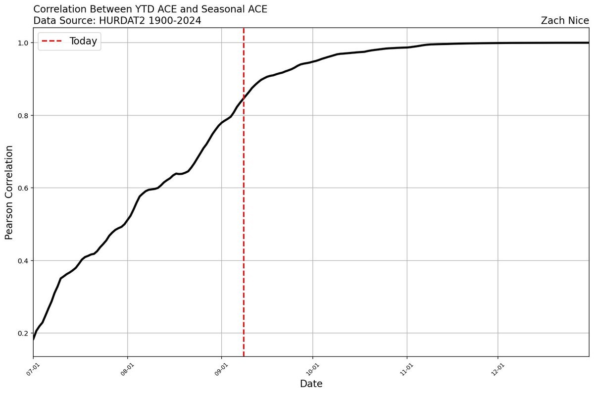
The Atlantic is exceptionally quiet for peak season, and there are few signs of TC formation within the next week. Since 1900, the correlation between YTD and seasonal ACE is now around r=0.84. Following climatology alone, 2025 should be expected to end up around 100 ACE total.
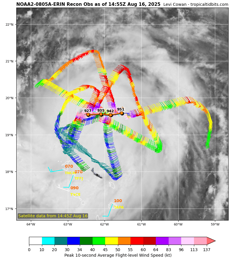
Probably one of the most impressive recon missions of all time right here from #Erin. Pressure plummeted into the low 920mb range and winds rose to borderline cat 5 strength.
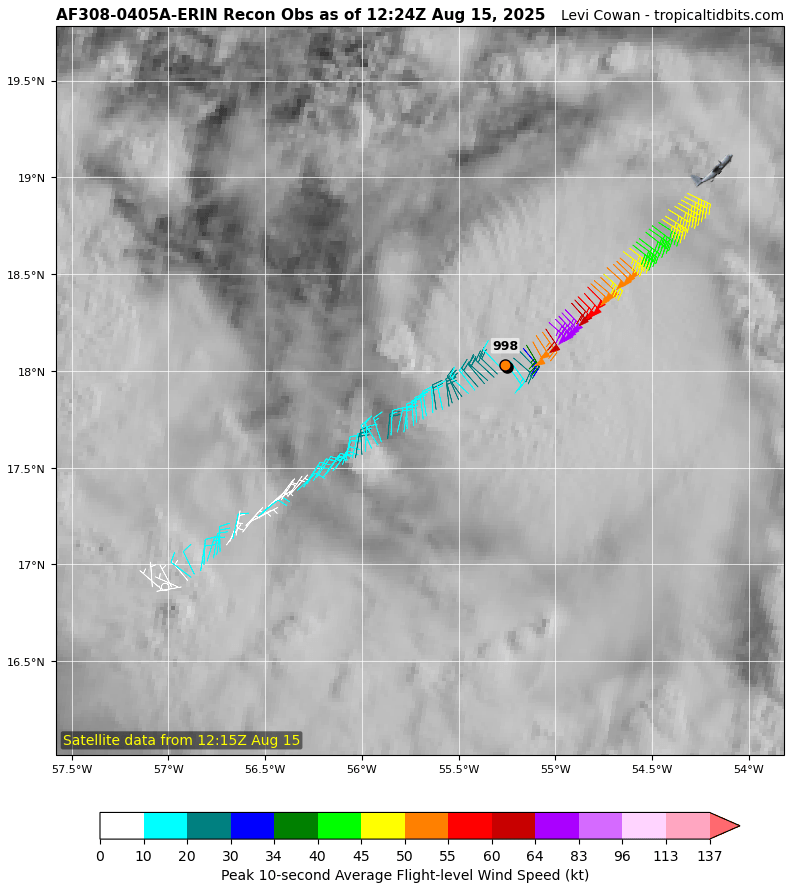
An aircraft currently investigating #Erin has found peak 700mb FL winds of 75kt, which indicates that Erin has strengthened into a 65-70kt hurricane. The hurricane also now has a closed eyewall at flight level as well. Rapid intensification seems likely today.
#Erin has been slow to organize today, likely due to some vertical tilt caused by nagging vertical wind shear. I wonder if this is going to change soon, as strong convection in the southeastern part of the storm amplifying is vorticity locally and may initiate alignment later.
@Mike__Gagliardi Yeah I would definitely tend to agree, but hurricane models have been suggesting a modest increase in shear tonight preventing it from really taking off with this burst. We'll see what happens!
#Erin is becoming significantly better organized this evening with a developing CDO cloud region and a well-defined spiral banding feature. Pending any further dry air intrusions, this should be the onset of a significant intensification period over the next 48hr or so.