NHC Director Dr. Michael Brennan warns on the catastrophic impacts from Major Hurricane #Melissa expected to make landfall early Tuesday morning along the south coast of Jamaica.
Keep track of the forecast at https://t.co/sYVOB3gScg
A significant microburst and thunderstorm hit Tempe at 1 p.m. today. It caused significant damage to some parts of Tempe, especially the area from Guadalupe to Elliott roads from Kyrene to Rural roads. If you do not need to travel, please stay off the roads. Tempe Police are directing traffic at the busiest intersections where traffic lights are out. If you see a fallen limb blocking a roadway, please call 480-350-8311. The National Weather Service stated that storm conditions are expected to last until approximately p.m. today, with additional storms expected to come. Please pay attention and drive safely. In the event of an emergency, please call 9-1-1. If you are out of power and need a place to go, these Tempe community centers are open until 6 p.m.: Escalante, Westside and North Tempe.
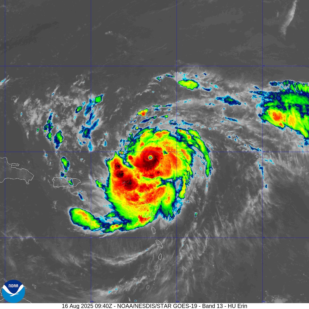
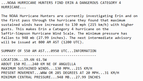
Aug 16 6AM AST: @NOAA_HurrHunter find #Erin has strengthened into a dangerous Category 4 hurricane with maximum sustained winds of 130mph. Stay up to date with the latest forecast at https://t.co/tW4KeGdBFb
11am EDT Mon Aug 11th - Tropical Storm #Erin has formed in the far eastern tropical Atlantic just west of the Cabo Verde Islands.
Maximum sustained winds are 45 mph & intensification is forecast as it moves westward across the open tropical Atlantic.
https://t.co/tW4KeGe9uJ
Burnet, Texas averages 32.34 inches of rain per year.
They have had 3 MONTHS of rain in the past 3 HOURS.
Burnet Municipal Craddock Field measured 3.6 inches in ONE HOUR and 8.60 inches in 3 hours between 4 a.m. and 7 a.m. just now and it’s STILL POURING.
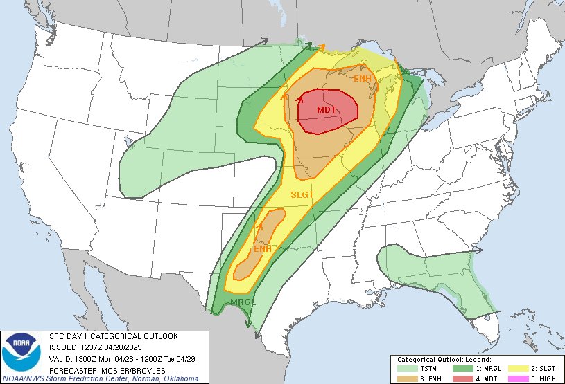
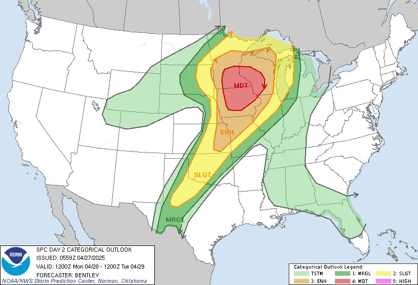
A very active severe weather stretch begins Wednesday and lasts into early next week.
If you live in the Corn Belt, Upper Midwest, western Great Lakes or Plains, you’ll want to pay attention through Tuesday.
The jet stream will dip over the western U.S., allowing cold air and low pressure to take shape over the Rockies. Periodic disturbances will eject eastwards, encountering warm, humid air and generating storms.
WEDNESDAY, May 14: Low pressure organizing over North Dakota will swing a cold front east. Thunderstorms will form around 4 p.m. in central Nebraska and the Dakotas. Moisture will be meager, so expect high cloud bases. That cuts back on the tornado threat. The main hazards will be damaging winds around 60 mph and some quarter-sized hail. Storms will quickly merge into a line and push east toward Interstate 29 after sunset.
THURSDAY, May 15: A potentially more significant day for Wisconsin, northern Illinois and *maybe* northern Indiana and Michigan. The low pressure system swirls a very warm, humid air mass northwards, leading to moderate to high instability, or thunderstorm fuel. The atmosphere will be plenty juiced up. Changing winds with height, thanks to a fierce jet stream overhead, strongly favor rotating storms. But “capping,” or a lid of warm air a mile above the ground, may prevent surface air from rising/forming storms. That could eliminate storm risk in most of Illinois and Indiana. Any storms that *do* form will be able to produce tornadoes.
FRIDAY, May 16: The cold front will sag south a bit, and some severe thunderstorms are possible from the mid-Mississippi Valley all the way to the Mid-Atlantic. Damaging winds are the main concern, since one or more storm complexes may try to ride along the west-to-east front and surf the jet stream east. Still, isolated hail or a low-end tornado threat can’t be ruled out.
SATURDAY, May 17: There’s a LOT of uncertainty on Saturday. This will occur as the first system begins to exit east, but the front will still linger across parts of Texas and Arkansas. It may serve as a focal mechanism for a few storms capable of producing damaging gusts or hail.
SUNDAY, May 18: A “dryline” will begin to take shape in north Texas, Oklahoma, Kansas and perhaps Nebraska. That’s the clash between bone-dry desert air west and moisture-rich Gulf air east. That clash *might* brew storms, but the trigger — an approaching upper-air disturbance — might still be too far west over the Rockies. Any storms that form could be severe.
MONDAY, May 19: The dryline will be parallel to Interstate 35. An upper-air disturbance will likely be working overhead, kinking the jet stream south. At this juncture, it looks like the greatest opportunity for widespread severe weather in traditional “Tornado Alley,” but details have yet to be ironed out.