Thats some otherworldly shit. Similar to how i felt caught between tornadoes during Milton. Hardly felt natural, like other forces were at play. Which obviously believe is the case.
National Chicken Wing Day is almost here and I've got eight of the best deals for cheap wings to celebrate!
All deals are valid on July 29th:
Wingstop: Get five wings free with $10 order using offer FREEWINGS
7-Eleven: Get a 10-pack of wings delivered through the 7NOW App for $8
Popeyes: Get a 6pc wings order free with $10 purchase in-app
Pizza Hut: Get BOGO wings using offer BOGOWINGS
Buffalo Wild Wings: Get six wings free with $15 order using offer FREEWINGS
Hooters: Get 10 wings for $7.29 with a drink purchase (dine-in)
Zaxby's: Get 10 wings for $10 (not sure if this is in-app or in-store)
Whataburger: BOGO 9pc orders of Whatawings in-app
Are you grabbing any of these deals?
#fastfood #chickenwings #chickenwing #cheapeats #cheapfood
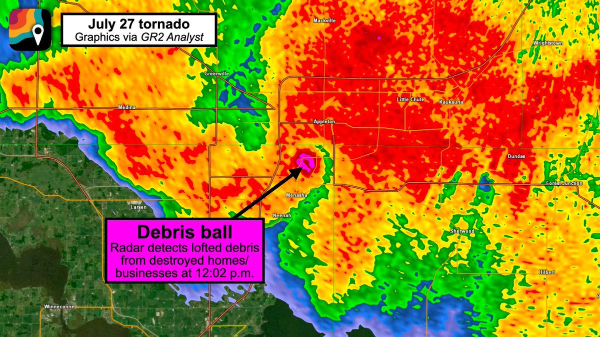
BREAKING: Appleton/Menasha tornado WAS LIKELY AN EF3, perhaps nearing EF4. Maximum winds probably 140 to 160+ mph!
Radar analysis suggests the tornado quickly formed between 11:55 a.m. and 11:59 a.m. somewhere near or just east of the railyards off West 2nd Street, then passing near Xavier High School and Prospect Avenue before crossing the Fox River. It then passed over U.S. 10, near the Menasha Youth Sports Complex and Route 47 (Appleton Road) and 3rd Street.
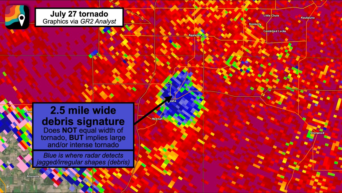
At 12:05 p.m., the tornado intensified, likely into an EF2 or EF3, and passed near/over Jefferson Park. An enormous debris ball appeared on radar, depicting pieces of homes and structures that had been lofted into the air.
The debris ball itself was more than 2.5 miles wide; that doesn't represent the width of the tornado, but does imply a large tornado.
The circulation appeared to further strengthen over Lake Winnebago while remaining near or just offshore the western side of the lake. (Tornadoes can intensify over water as they encounter less frictional drag.)
The tornado dissipated over the lake east of the town of Winnebago between 12:20 and 12:25 p.m. after being on the ground for approximately 30 minutes. Debris was lofted to between 16,000 and 20,000 feet, commensurate with a high-end EF2 to EF3 tornado.
Rotational velocity, or the difference between the fastest "toward" and "away from" pixels on radar velocity, was 96 knots. That's well within the range for an intense EF3+ tornado.
The tornado formed on a day when the Storm Prediction Center only called for a "marginal" tornado risk, BUT the setup was classic for northwest flow supercells. Dew points were near 80 degrees, meaning more humidity than anywhere in the Amazon Rainforest.
Moreover, there was a boundary draped south to north boundary on the west side of Lake Michigan. Our storm latched onto that boundary and gobbled up all the extra low-level helicity (spin) along it, stretching it efficiently and producing a significant tornado.
It's worth noting that the rating will ultimately come down to what damage the National Weather Service finds. The Enhanced Fujita scale does NOT rate tornadoes, but instead only rates damage. Damage is used as a proxy for tornado strength, though most tornadoes are 1-1.5 categories stronger in reality than their EF scale-rated damage implies.
This is what 100 MPH Winds look and sound like.
Watching this unfold behind the scenes on Connor's stream was insane.
This was right at the beginning of the Derecho near Joliet, Illinois.
Wow! Scary. Sound up!
I don’t know about you, but this is my biggest fear.
This is why we say Stay Inside when #lightning is nearby! Thanks Gregory Best in Odessa! Glad you are ok!!
There was a ton of lightning in #Florida today.
BREAKING: It appears we have the SECOND HIGHEST thunderstorm wind gust ever directly recorded in the United States.
Winds to 131 mph – equivalent to an EF2 tornado – were measured around 6:15 a.m. in central South Dakota.
There were multiple corroborating measurements AND several additional gusts over 110 mph nearby.
Based on everything we can find, these are the strongest straight-line thunderstorm gusts to be directly-measured since August 1, 1983, when a microburst hit Andrews Air Force Base in Maryland. Just seven minutes earlier, Air Force One had landed with Ronald Reagan. A gust to 149.5 mph was clocked.
A derecho, or violent straight-line wind storm, did impact the Cedar Rapids, Iowa area with 140 mph winds on August 10, 2020; several transmission towers were felled and up to 8,000 buildings damaged or destroyed. But the strongest directly-measured gust was 126 mph in Atkins, Iowa.
"You are in a life-threatening situation," warned the Weather Service in Aberdeen on Monday morning. "Flying debris may be deadly to those caught without shelter. Mobile homes will be destroyed. Expect considerable damage to homes and businesses. Expect extensive tree damage and power outages."
Much of the impact-based verbiage was borrowed from the Weather Service's template for tornado warnings. Only on rare occasions is that phrasing used in severe thunderstorm warnings. That said, the impacts were similar.
"This is an EXTREMELY DANGEROUS SITUATION with tornado-like wind speeds expected," wrote the Weather Service.
The storms accompanied a warm front lifting through the region. Despite the early time of day, there were between 5,000 and 6,000 units of thunderstorm fuel; 1,000-2,000 is enough to fuel severe thunderstorms.
The storms were effectively able to grow tall and tap into jet stream energy, mixing momentum to the surface.
It is unclear if Monday's storm will be classified as a derecho. While the winds were surely sufficient, a derecho must produce a damage path about 250 miles long. Moreover, historical definitions required a wind swath 60 miles wide. This bow echo may have been slightly too narrow. The Storm Prediction Center will have the final say.