Cool slide from @jedsundwall´s talk during #FOSS4GNA showing how quickly the open source building footprint dataset we´ve published on @source_coop a few weeks ago was picked up.
Shows the power of open access data & having a capable platform like @source_coop for distribution.
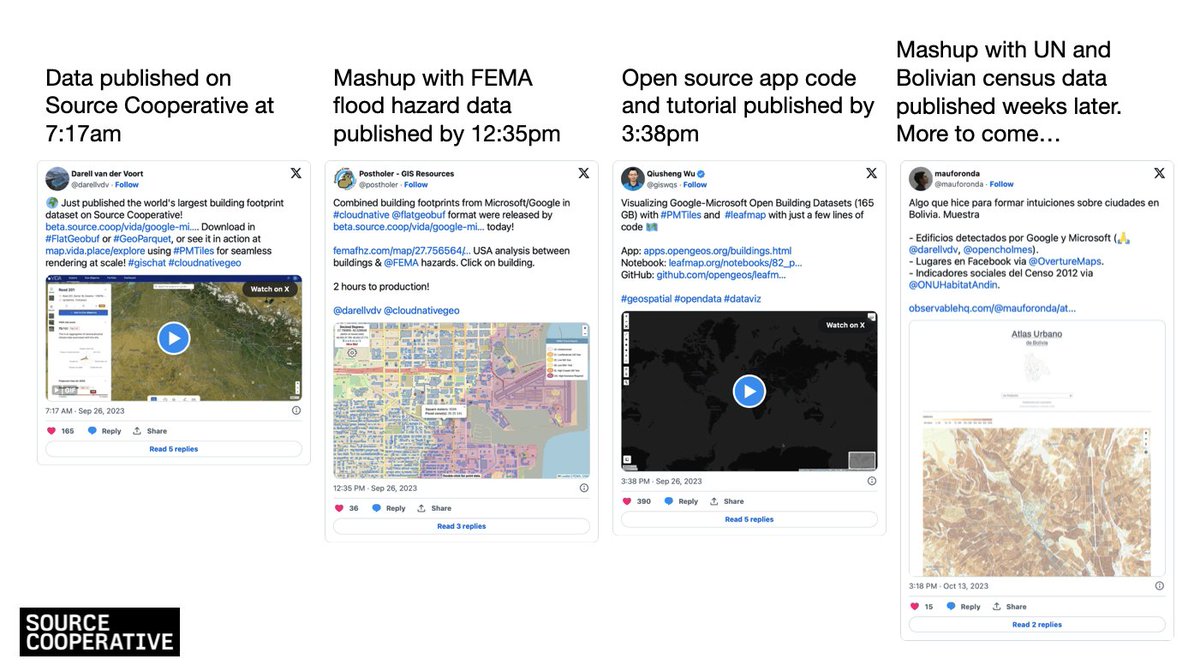
Loooove to see people building on top of the building footprints that @VIDAplace put on @source_coop. Data begets data begets data…
Además este atlas es súper lindo, felicidades @mauforonda! 👏
This #TutorialTuesday is focused on the data below. Learn how to access its @cloudnativegeo formats through @source_coop using @duckdb, its partition strategies & tests that compare the merged dataset w/ just the Google V3 building footprints
https://t.co/ecCdGs0ZCX
✨ A successful ESA-backed demonstration project by German company @VIDAplace has attracted €3 million of investment from Cusp Capital. VIDA’s solution, originally developed under the @ESA Business Applications programme, uses satellite-enabled software to accelerate sustainable infrastructure investment and impact management. The funding will enable VIDA to scale its operations, expand its product offering and build its presence in key markets worldwide.
Read more ➡ https://t.co/6SvprAyNUU
📷 Vida's founders (L to R): Philippe Raisin, Nabin Raj Gaihre and Tobias Engelmeier
This #TutorialTuesday is focused on the data below. Learn how to access its @cloudnativegeo formats through @source_coop using @duckdb, its partition strategies & tests that compare the merged dataset w/ just the Google V3 building footprints
https://t.co/ecCdGs0ZCX
Combined building footprints from Microsoft/Google in #cloudnative@flatgeobuf format were released by https://t.co/7RbNRypIsm today!
https://t.co/MRazLTClfB USA analysis between buildings & @FEMA hazards. Click on building.
2 hours to production!
@darellvdv@cloudnativegeo
Here´s the blogpost on @cloudnativegeo about the worlds largest Google+Microsoft combined building footprint dataset we´ve published yesterday on Source Cooperative. Tutorials to follow soon.
https://t.co/J5fxqzmUCV
Combined building footprints from Microsoft/Google in #cloudnative@flatgeobuf format were released by https://t.co/7RbNRypIsm today!
https://t.co/MRazLTClfB USA analysis between buildings & @FEMA hazards. Click on building.
2 hours to production!
@darellvdv@cloudnativegeo
🌍 Just published the world's largest building footprint dataset on Source Cooperative! https://t.co/ZsGuI3gQIH. Download in #FlatGeobuf or #GeoParquet, or see it in action at https://t.co/P1wFepmtKR using #PMTiles for seamless rendering at scale! #gischat#cloudnativegeo