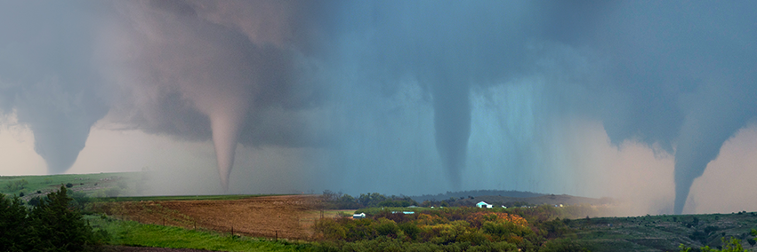
Tescott/Culver Kansas wedge tornado on May 1, 2018. This EF-3 tornado was a half mile wide and tracked 14.5 miles. Fortunately there was no fatalities or injuries reported. #kswx
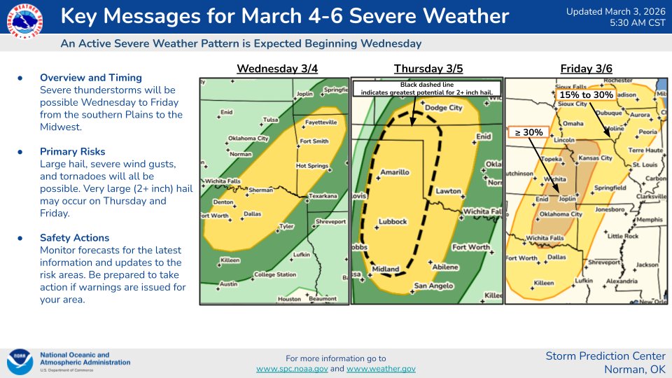
An active severe weather pattern is expected later this week. All severe weather hazards, including large hail, severe wind gusts, and tornadoes, are possible. Very large (2+ inch) hail may occur on Thursday and Friday.
10AM #Melissa Update: @53rdWRS and @NOAA_HurrHunter Hurricane Hunter aircraft find that Melissa continues to strengthen. Catastrophic winds are moving onshore southern Jamaica. THIS IS THE LAST CHANCE TO PROTECT YOUR LIFE! For more updates visit https://t.co/tW4KeGe9uJ
10/27 5am EDT: #Melissa has strengthened to a Category 5 hurricane with 160 mph winds and a 917 mb central pressure, confirmed by the Air Force Reserve Hurricane Hunters. Conditions in #Jamaica will rapidly deteriorate later today and tonight. Here are the key messages:
See https://t.co/Wq6ZtKfHp9 for the latest details.
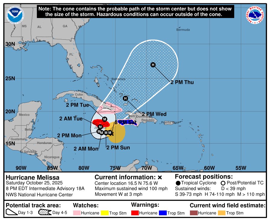
Hurricane #Melissa Advisory 18A: Noaa and Air Force Reserve Hurricane Hunters Report Melissa is Strengthening. Life-Threatening and Catastrophic Flash Flooding and Landslides Expected in Portions of Southern Hispaniola and Jamaica Into Early Next Week. https://t.co/tW4KeGdBFb
🚨#BREAKING: Watch incredible footage as Hurricane Hunters fly into the eye of Hurricane Erin, a powerful Category 5 storm to collect critical data
📌#Atlantic | #Ocean
Watch incredible footage as NOAA Hurricane Hunters and the U.S. Air Force’s 53rd Weather Reconnaissance Squadron fly straight into the eye of Hurricane Erin. These crews risk dangerous turbulence and extreme conditions to collect vital data on wind speeds, pressure, and storm structure information that satellites alone can’t capture. Erin has rapidly exploded from a Category 1 to a Category 5 monster with sustained winds of 160 mph. Forecasters use the data gathered from these flights to fine tune models, track the storm’s path, and improve warnings that help save lives. While current forecasts suggest Erin will curve out to sea and spare the U.S., its explosive growth highlights the importance of the Hurricane Hunters’ mission
Last night, the 53rd Weather Reconnaissance Squadron flew into the eye of Hurricane Erin—and captured imagery of the breathtaking stadium effect.
These missions provide critical data to the NHC to improve forecasts, helping keep communities safe before the storm makes landfall.#readynow #weatherready
August 16: 11:20AM AST @53rdWRS find #Erin is now a Category 5 Hurricane with maximum sustained winds of 160 mph. Visit https://t.co/tW4KeGdBFb for the latest
Aug 16: Images from @NOAA_HurrHunter and the @NOAASatellites Ocean Winds team show an intense eyewall in Hurricane #Erin This photo shows the ocean surface calm in the eye and roaring in the eyewall. For the latest forecast visit https://t.co/tW4KeGdBFb
Flash flooding has caused the Lampasas River to crest to nearly 40 feet as of 4:45 PM at Ding Dong, Texas. Video from Youngsport and Ding Dong along the Lampasas River this afternoon.
⛈️ WILD RIDE: A storm chaser has captured his harrowing drive through the Texas Panhandle, battling supercells, windshield-shattering hail and blinding walls of dust. >> https://t.co/lJqx7QkmVu
Chased multiple supercells from the Texas panhandle down into west Texas yesterday afternoon. These storms produced hail up to 4.25” and damaging winds of 90 MPH recorded.