Aerial views of an accident on southbound I-49 at exit 72 in Springdale, AR closing down all southbound lanes of the interstate. Roads are still icy and snow covered in many areas. Live coverage of WS Kingston continues on @weatherchannel.
Dearest mother —
The battleground has called for my glorious return. I’m thrilled to say, I shall heed that call.
I have reenlisted.
While my sidearm is permanently holstered — I shall help train other young men to be great soldiers. Please send care packages of squirrel oil and skunk cakes to our basecamp at Stanford. I love you.
— Andrew
The Benton County, Arkansas tornado as it was headed toward Decatur about to cross Highway 59. This was taken at 1:12 am this morning looking northwest from the Simmons Plant parking lot north of Gentry. @NWStulsa#arwx#wx#tornado
Northwest Arkansas was hit hard by tornadoes early this morning with downtown Rogers being one of the hard hit areas. Aerial footage shows some of the destructions Shortly after it hit and then after daylight. @weatherdan@4029Darby@ToddYakoubian#arwx#tornado#arkansas
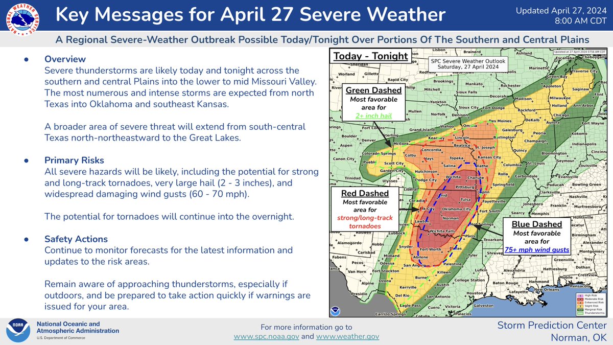
⚠️Sat 4/27/24
A Regional Severe Weather Outbreak is possible over the Plains and mid MS Valley today/tonight.
Numerous severe thunderstorms are possible over parts of OK, KS and North TX . Strong, long-track tornadoes, very large hail, and damaging winds are likely
Marty Logan is tracking a large wildfire near Sharon, OK and it's quickly spreading NE. 2 firefighters have been injured. A shelter is opening at Woodward Pioneer Room for evacuees from the town of Sharon. #okwx
[8:48 am - 4/1/24] UPDATED severe thunderstorm risk areas and threats for E #OKwx, NW/W Central #ARwx. Very large hail is the main threat w/parts of NE OK, SE OK targeted for local maxes in tornado potential. Timing hasn't changed.
Check this out! NextGen Live showed something really cool at the time of the 4.4 magnitude earthquake last night. All the blues you see erupt inside of the red circle are birds taking flight from their roosts after the earthquake spooked them! #okwx


![NWStulsa's tweet photo. [8:48 am - 4/1/24] UPDATED severe thunderstorm risk areas and threats for E #OKwx, NW/W Central #ARwx. Very large hail is the main threat w/parts of NE OK, SE OK targeted for local maxes in tornado potential. Timing hasn't changed. https://t.co/VJ89cZXz2M](https://pbs.twimg.com/media/GKFXAhPaoAAgHqi.jpg)
![NWStulsa's tweet photo. [8:48 am - 4/1/24] UPDATED severe thunderstorm risk areas and threats for E #OKwx, NW/W Central #ARwx. Very large hail is the main threat w/parts of NE OK, SE OK targeted for local maxes in tornado potential. Timing hasn't changed. https://t.co/VJ89cZXz2M](https://pbs.twimg.com/media/GKFXAhObEAA6b7J.jpg)