#SVQ il y a maintenant plus de 674 000 images satellite RADARSAT-1 de 1995 à 2007 gratuites sur #SGDOT? Consultez-les ici 👇
📡 https://t.co/BYtFWl3X2B
🛰️ https://t.co/ARpxpRPPco.
🌎 https://t.co/J7qAZCGrUX
@StephenBlais Holidays can bring desperation. #Ottawa has its own desperate, perhaps quieter..suffering this holiday no loved ones and no money to eat. Hoping @OttawaFoodBank is channeling everyone's generosity into empty tummies this season🎄❄♥
Amazing album guys!! "ONE MORE SATURDAY NIGHT". "OG" pierced our hearts. The whole album is fresh, amazingly diverse with a track for every mood, every ear. Keep it coming. Canada needs this! @atribecalledred#TRCCanada
#CCMEO supports Northern communities through #OpenGov and #OpenData. Check out our recent release of 3,000 digital aerial photos in the #Tuktoyaktuk region from 1947 to 1990: https://t.co/loDAIA4Aqa
@NRCan’s Earth Observation Data Management System has launched open access to #OpenData from #RCMSatellites. We invite all to explore this valuable resource – no registration required for the website or API! https://t.co/JMfpgfWKfy
#OpenScience#NRCanMaps#OpenMaps
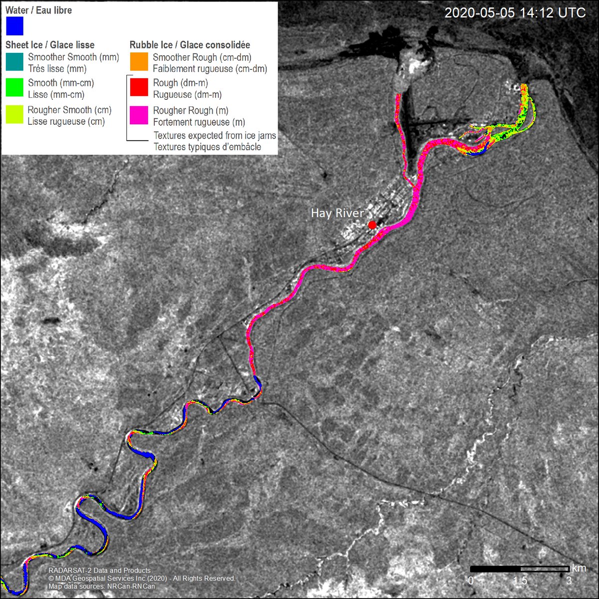
Our Emergency Geomatics Service produced this river ice breakup map from #RADARSAT-2 imagery downlinked at our Prince Albert Satellite Station. This data helped the town of Hay River, NWT, decide to evacuate.
Available here: https://t.co/2ukqceqYqq @csa_asc @MDA_maxar
@CDS_GC do you guys (or anyone in the GC) offer a GC version of https://t.co/Wa41OB4kNl? GC depts. have deferred to use forms on google infrastructure, but it would be more ideal to use a GC owned one (cloud-hosted or otherwise)
@_VincentS_ @arjenvrielink@rsimmon@John_M_Nelson@MikeSafyan The web UI is based largely on the government's WCAG-compliant templates. There are plans to catch up to the https://t.co/cuFSmsHzeg look and feel. Just curious: what's your favourite EO catalog?
Quelle réalisation! Voici un bel exemple de collaboration entre @RNCan et @asc_csa . Je suis très fière d'avoir travaillé sur RADARSAT-1, des opérations aux #donnéesouvertes
Je suis heureux et fier d’annoncer que plus de 36 000 images de RADARSAT-1 sont ouvertes et accessibles sur notre Système de données d'observation de la Terre https://t.co/l9Eetbcgsq. Un moment historique dans le mouvement des #donnéesouvertes au Canada! Bravo @RNCan et @asc_csa
Pleased and proud to announce that over 36,000 RADARSAT-1 images are open and accessible on our Earth Observation Data Management System https://t.co/C3ABiFlz3Q. Such a historic moment in Canada’s #OpenData movement! Great work @NRCan & @csa_asc