⚡️@NWSGrandRapids has recorded 27 thunderstorm days for 2026 through June 14.
That's the most number of thunderstorm days year to date since daily thunderstorm records began in 1903 - over 120 years!
In second place was 2024 with 22 thunderstorm days.
#wmiwx#miwx
ALL-TIME PEAK WIND GUST RECORD TIED AT GRAND RAPIDS, MICHIGAN
On April 14, 2026 a peak wind gust of 81 MPH was recorded at @FlyGRFord. This ties the record set just last March 30, 2025.
@NWSGrandRapids broke an all-time record twice in a little over a year!
#wxmiwx#miwx
The 2nd daily precipitation record for the month was set on Tuesday, April 14 with @NWSGrandRapids recording 1.92". The old record was 1.07" in 1987.
@CityofHolland tied their record of 1.02" in 1983.
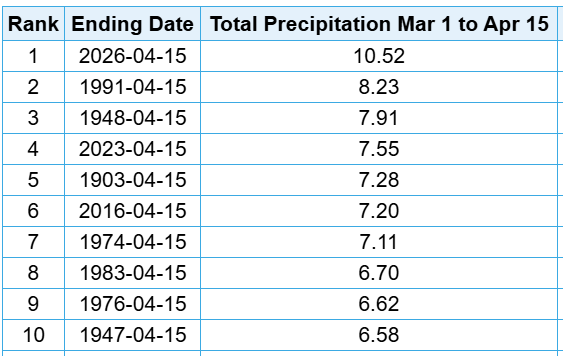
Check out the GR March 1 - April 15 precipitation ranking!
#wmiwx#miwx
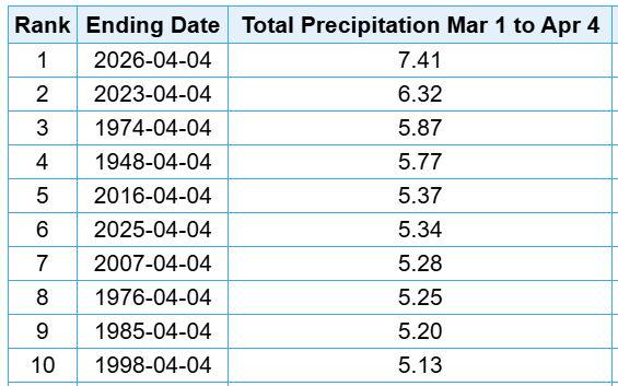
Wettest March 1 - April 4 period on record!
Grand Rapids, Kalamazoo and Muskegon are all experiencing their wettest start to Spring on record.
Kalamazoo has received 7.78" and Muskegon 8.55".
The top 10 for Grand Rapids:
@NWSGrandRapids#wmiwx#miwx
Our active Spring pattern has produced our wettest start to spring on record and two new daily rainfall records:
☂️Muskegon on April 2 of 1.37" (old record of 0.94" in 1983)
☂️Grand Rapids on April 4 of 1.53" (old record of 1.27" in 2003)
#wmiwx#miwx
March 2026 recorded 37% of possible sunshine at @MIKCRC near @FlyGRFord .
The makes it the 16th cloudiest March on record since records began in 1904.
We'll work on doing better in April!
@NWSGrandRapids#wmiwx#miwx
The first 18 days of March have delivered only 33% of possible sunshine at @NWSGrandRapids leading to the cloudiest March to date since 2019.
Normal sunshine is 47%.
#wmiwx#miwx
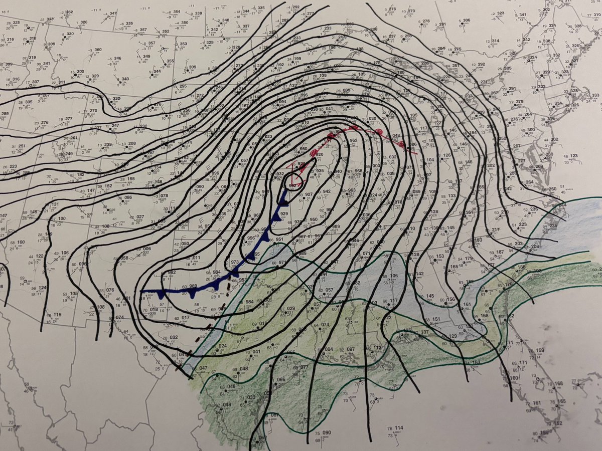
Here at the Storm Prediction Center, we dig deep into the data to do the best possible analysis of the storm threat. Even in 2026, this sometimes involves putting pencil to paper to do hand surface analysis. This is what the morning map looks like today.
If you thought it had been a while since we were this windy - you were right!
The average wind speed yesterday, March 13 at @FlyGRFord was 24.0 MPH.
The last time we were this windy was December 16, 2021 when the average wind speed was 25.3 MPH.
@NWSGrandRapids#wmiwx#miwx
The 8th warmest start to March on record at @NWSGrandRapids produced two more record highs in the area yesterday, March 9:
Grand Rapids 71° (old record of 68° in 2000)
Battle Creek 71° (old record of 68° in 2016)
#wmiwx#miwx
*132 YEAR OLD DAILY PRECIPITATION RECORD BROKEN*
UPDATE: For March 6, @NWSGrandRapids ended up recording 1.55" of rainfall. This crushes the previous daily record of 0.68" in 1894.
#wmiwx#miwx
*132 YEAR OLD DAILY PRECIPITATION RECORD BROKEN*
Through 5PM, @NWSGrandRapids recorded 0.87" of rainfall. This breaks the previous daily record of 0.68" in 1894.
@CityofHolland also set a precipitation record of 1.11" breaking the old record of 0.55" set in 1961.
#wmiwx#miwx
☀️46% ☀️
Grand Rapids, Michigan experienced their 14th sunniest February on record with 46% possible sunshine being recorded at the @MIKCRC near the @FlyGRFord airport.
We slowly gain another hour and one-half of possible sunshine in March!
#wmiwx#miwx
☀️A wonderfully warm day in West Michigan including records highs for February 18:
Grand Rapids 60° (old 59° in 2017)
Holland 58° (old 57° in 1961)
Muskegon 54° (ties 54° in 1994)
#wmiwx#miwx
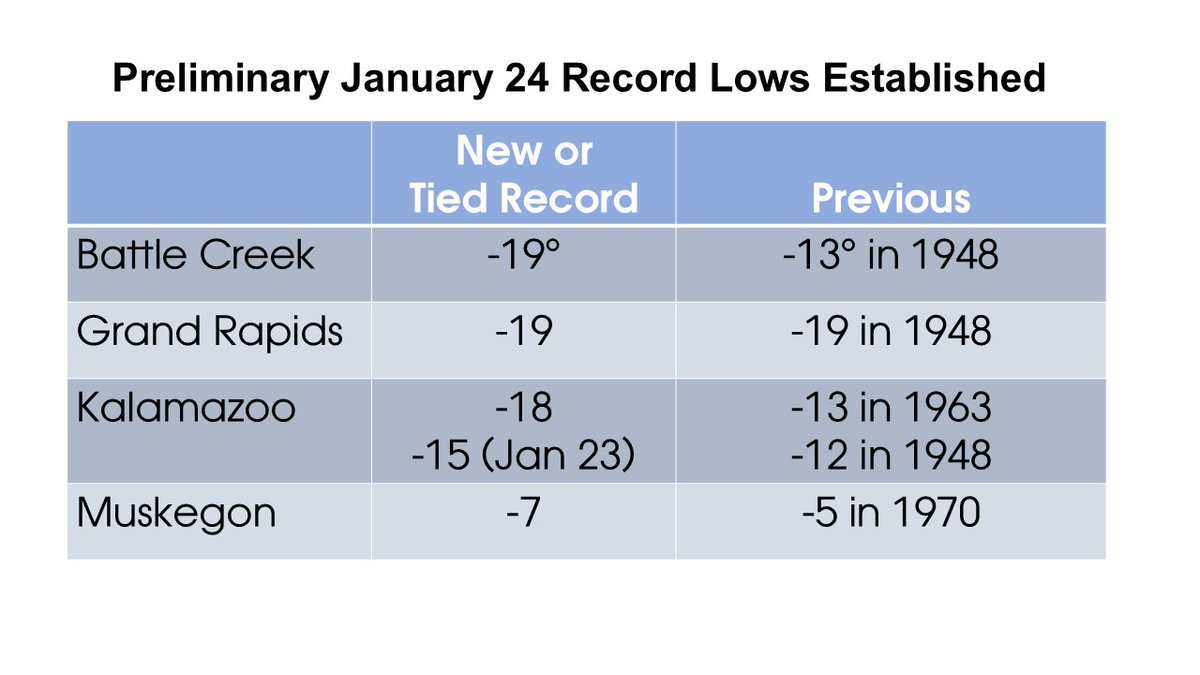
To help put into context our tied record low this morning:
Since records began in the 1890's, only 15 other times have we experienced a low temperature of -19° or colder at @NWSGrandRapids#wmiwx#miwx
From the NWS:
SINCE RECORD KEEPING BEGAN IN THE
1890S, GRAND RAPIDS HAS RECORDED -20° OR COLDER ONLY 11 TIMES, MOST RECENTLY IN JANUARY 1994.
IF THE CLOUDS STAY AWAY WE COULD MAKE A
RUN AT IT. ONE MODEL GIVES US -24°, WHICH WOULD TIE THE COLDEST READING EVER RECORDED.