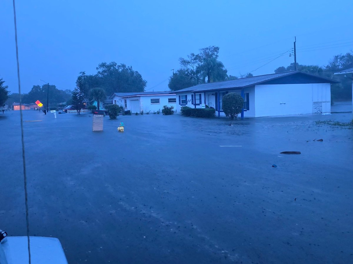
Just devastating. Some say worse than a hurricane. I agree. So many have been impacted by recent floods it is hard to put into words. Rode along with Florida FWC in Cocoa, Florida on a water rescue and saw things firsthand. Families stranded. Vehicles flooded. Water in homes. Having to salvage what they can as they try and escape the rising waters. Helped this family and their dogs. Really puts things into perspective. Hoping everything will be ok for them. And to everyone else these past couple weeks that have been hit so hard. Unprecedented flooding to say the least. Historic.
WEATHER UPDATE: Kennedy Space Center Visitor Complex re-opens on Saturday, November 21 with a few changes to guest parking. Due to high water, the primary entrance from Space Commerce Way is temporarily closed. Please follow the alternate arrival instructions below.
Arrival Instructions:
- Guests should arrive via S.R. 405/NASA Parkway. Do not turn onto Space Commerce Way.
- Continue on S.R. 405/NASA Parkway to the next traffic light.
- Turn right at the traffic light to access Kennedy Space Center Visitor Complex.
- Follow onsite signage and directions from parking attendants upon arrival.
Parking Information: Parking fees are currently waived.
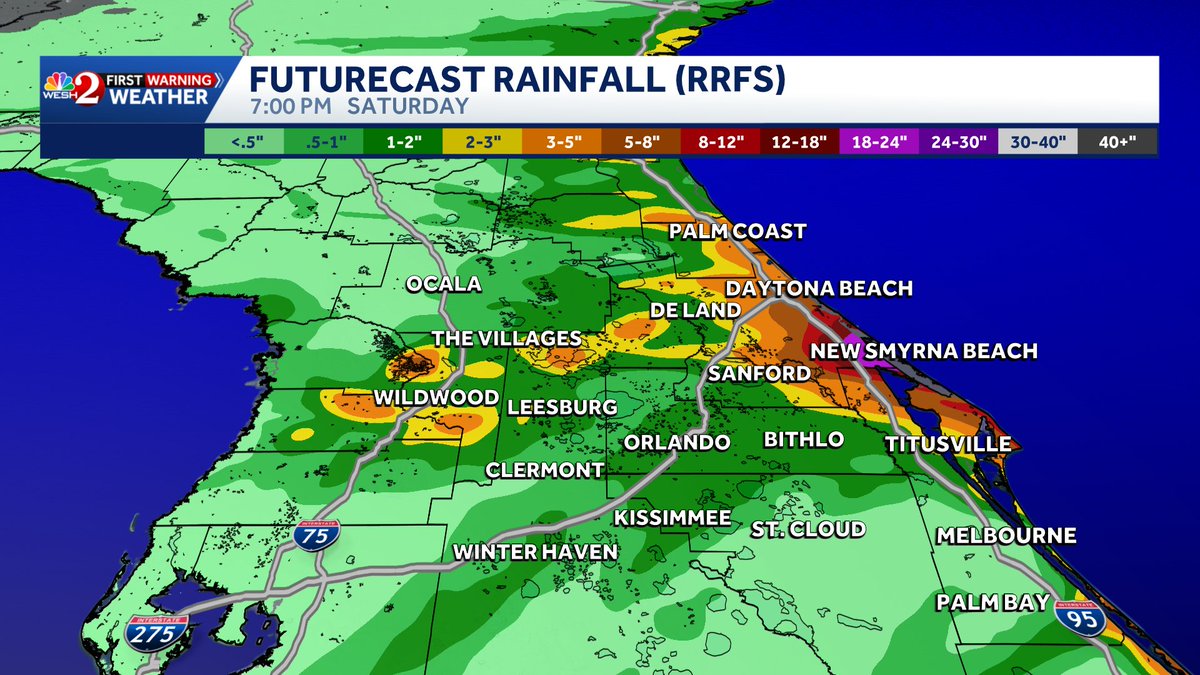
Many of our local high resolution models are indicating another round of significant rainfall Friday into Saturday then a look how it all may play out. Amounts could add up to another 10" of rain in #Brevard county. Stay with #weshwx for updates.
5pm Thu 11/19 | Another round of locally heavy rain is forecast to begin tonight and last at times into Friday as low pressure develops and drifts northward near the east coast of Florida. Any additional rain in saturated areas will prolong or cause renewed flooding. #FLwx
#Weather#Florida#SpaceCoast
Personal note ... My home and neighborhood came through the Great Deluge okay. Some nearby neighborhoods were not designed to drain well.
@NASAKennedy is seven miles up the road. Hopefully @NASA will tell us soon how KSC fared.
Here's a look at the latest storm totals from #Brevard#Volusia and #Flagler counties. More rain is on the way today into Saturday. Stay with #weshwx for updates.
The state is starting to post major road closures:
[11:10:25] 511: Closure — US-1 Northbound — Flooding in Brevard County on US-1 North, at Barnes Blvd. All lanes closed
[11:17:00] 511: Closure — SR-501 All Directions — Flooding on SR-501 All Directions Near Lake Dr. All lanes closed
[11:18:06] 511: Closure — US-192 / Vine St / Bronson Hwy Eastbound — Flooding in Brevard County on US-192 / Vine St / Bronson Hwy East, from Coastal Ln to beyond Minton Rd/S Wickham Rd. All lanes closed US-192 at CR-509
[11:18:06] 511: Closure — SR-A1A All Directions — Flooding on SR-A1A All Directions Near Grosse Pointe Ave. All lanes closed
[11:19:12] 511: Closure — US-1 All Directions — Flooding on US-1 All Directions Near CR-502. All lanes closed
[11:20:17] 511: Closure — Brevard Dr All Directions — Other on Brevard Dr All Directions Near CR-507. All lanes closed
[11:20:17] 511: Closure — SR-A1A All Directions — Flooding on SR-A1A All Directions Near Coral Sea Way. All lanes closed
[11:20:17] 511: Closure — SR-A1A Southbound — Flooding on SR-A1A Southbound Near Jupiter St. All lanes closed
[11:21:23] 511: Closure — US-1 All Directions — Flooding on US-1 All Directions Near CR-515. All lanes closed
[11:21:23] 511: Closure — US-1 Southbound — Flooding on US-1 Southbound Near Cottrell Ave. All lanes closed
[11:23:36] 511: Closure — SR-513 Southbound — Abandoned Vehicle on SR-513 Southbound Near Shrike Dr. All lanes closed
10:05 AM | The Flash Flood Warning has been upgraded to a Considerable threat for portions of Brevard County. Between 3 and 7 inches of rain have fallen. Additional rainfall amounts of 2 to 4 inches are possible in the warned area.
CLOSURE ALERT: For the safety of our guests and employees, Kennedy Space Center Visitor Complex will be closed Friday, November 20, due to heavy rains and potential flooding in the area.
We appreciate your understanding and will share updates as conditions improve. Please continue to check our social media channels and website for the latest information.
https://t.co/bfm2aTLlqV
Wow! Deep water seen around Rockledge and Cocoa this Thursday morning.
We are approaching really major flooding. Warnings are in effect.
📸: Morgan Rafalko
@NWSMelbourne@fox35orlando
7:30AM: RELENTLESS rain as expected in Brevard County. Sadly, the forecast from yesterday is happening just as it looked. Already 16”+ rain from this event in Port Canaveral, 12”+ in Rockledge. A solid 4-8 more hours of rain. Close to having Flash Flood Emergency issued from NWS. Doesn’t change much of the action needed though at this point. The flooding is bad, and only getting worse this morning. Worse off in northern Brevard. Coastal convergence and mid level warm front to the max. Wringing out the moisture in the atmosphere like a wet towel.
US-1 in Port St. John is completely inundated with water. FL DOT is monitoring the situation on scene. One car that attempted to pass ended up in a ditch along the side of the roadway. @NWSMelbourne
Latest RRFS; doing well I think in this event. An additional 10-25” of rain in northern Brevard - model run from 2am Thursday through Friday night.
Major flood event getting started.
5:30 AM | A Flash Flood Warning continues for portions of Brevard County until 7:45 AM EST. Between 4 and 6.5 inches of rain have fallen over the past 12 hours. Additional rainfall amounts of 3 to 5 inches are possible in the warned area.
NEW MODELS: 2-day future rainfall totals from the high-resolution models. HRRR, GRAF and RRFS. If you ever want to see how hard weather forecasting is, make a prediction for Melbourne below based on these models. All three do still indicate the potential for significantly higher totals in localized spots of 10-20", like we saw last night in Broward County. RRFS goes bananas with even higher. Let's hope they're wrong.
2:20 AM | A Flash Flood Warning has been issued for portions of Brevard County until 5:15 AM EST. Between 2 and 2.5 inches of rain have fallen over areas that have already received heavy rainfall over the past 12 hours. Additional rainfall amounts of 1-2 inches are possible.
Here's a look at the latest rainfall forecasts based on tonight's model data. Greatest totals will be along the east coast of #florida and it's also where the greatest flood risk will be through #Friday. Stay with #weshwx for updates.