Still lots of QC'ing and processing to do, but the early lidar data shows the tornado was initially moving north-northeast before stalling and intensifying (in some unfortunate beam blockage) and then moving due east.
🌪️05/17: The LIFT project used LiDAR & mobile mesonets to sample ground-level wind flow on a strong tornado in Nebraska.
This type of data of both the tornado itself AND its formation at such close range and proximity to ground is rare and valuable.
🔗: https://t.co/14LLWKo93r
@Brady_Wx We noticed the ground relative wind was oddly weak for the inflow of a supercell that looked like that. At one point before this it was only 5 kts.
@GumryWX@DualDoppler That is 6 hours of model runs that have not been corrected for nocturnal PBL errors in the EML region. That could be a pretty big deal considering the 12 Z model runs often set the stage for Day 1 risk. Diurnal transition periods are a pretty sensitive time for models.
@sambrandt99 Low-level mesocyclones can be primarily driven by ambient very low-level shear (see Coffer et al. 2023), so I don't think that magnitude of baroclinic vertical vorticity is necessarily a given with a strong low-level mesocyclone.
@sambrandt99 A cheat code is something that makes the game easier, right? That seems to fit the definition. You really would need values greater than Coriolis though before it could possibly matter.
@sambrandt99 This is probably too strong of a statement. Vorticity of 0.0003 over a 4 km radius area has a circulation of 15, 079 m^2 s^-1. At least theoretically, that can significantly cut down on the amount of vorticity the storm needs generated to produce a tornado.
This suggests that storms might not need to generate their own vertical vorticity to form tornadoes when there are strong coherent structures in the inflow and we would expect those structures to be strongest in the highest shear environments (like the southeast US).
I am excited to share the EOR of our latest BAMS article! We used the @NOAANSSL truck mounted Doppler lidar to show that supercells have coherent streaks of vertical vorticity, which we refer to as vorticity worms, in their inflow. https://t.co/nHr198z650
Conceptual models of tornadogenesis have often overlooked the inflow as a source of vertical vorticity, but the inflow is actually not devoid of vertical vorticity. Coherent turbulence found in sheared environments generates vertical vorticity right near the ground in the inflow.
@jschaut27 If it keeps trending north I do see a small chance that the Pittsburgh area flirts with a change over to sleet/freezing rain, but I don't think that is likely right now.
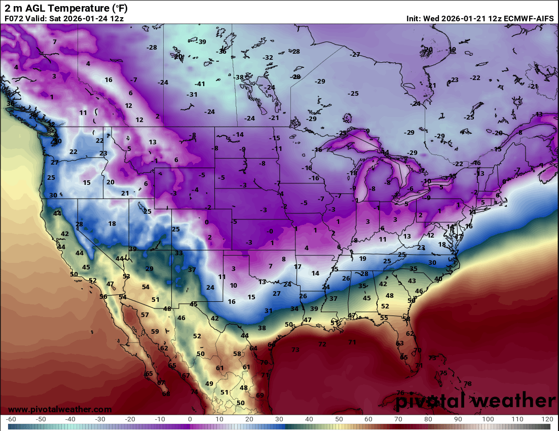
If the warm nose is as strong as what is shown by the ECMWF then I think that it's 2-m temperature over the southern Plains is garbage. I would be willing to bet that the freezing line is closer to Houston than Dallas at 12 Z on Saturday. It's AI companion has the right idea.
@jschaut27 I feel pretty good that most of PA will get snow. Only question now is if it is just 6 inches or if it really goes off and the current trend is for it to really go off. The potential is there for a widespread area of over a foot since liquid to snow ratio should be high.
NSSL 2025 "WRAPPED" Take a look at the tornadoes that defined our year! 🌪️
⛈️ Precise measurements of free-falling hail and tornado winds lead to better prediction methods, can lead to improved building design standards and ultimately help keep people safe. @NOAAResearch@NOAA
🌪️Rare start to finish EF‑3 Tornado Data Captured 🌪️
On 5/18/25 a tornado touched down near Arnett, Oklahoma. Our researchers were in place to intercept the storm and capture stunning data of the EF3-rated tornado from beginning to end. 🌪️🔬
FULL STORY: https://t.co/uJueTmXihu
🌪️🌩️ Studying tornadoes in the field has always been at the heart of the NSSL mission. With roots in the 90s, the VORTEX-USA project continues to blaze a trail in tornado science with the ultimate goal to protect lives and property.
🌪️ UP CLOSE: https://t.co/X8gEB9Jz1p
Add in the low-level clouds and there is no chance for the temperature to recover in time to meet the high temperature. Models really struggle with this because they can't properly resolve the inversion so the northerly winds in the cold air mass are often underestimated.
Classic conditions for a central Oklahoma high temperature bust. Shallow cold air with high pressure to the northwest. The negatively buoyant air over the sloped terrain enhances the northerly winds in the cold air which causes the it to surge farther south.