This system is already onshore so it will not into a tropical cyclone. However, according to WPC, the coast TX and LA will still receive 50-100mm (2-4 inches) of rain, potentially leading to flash floods. Be extra careful if you are currently staying there.
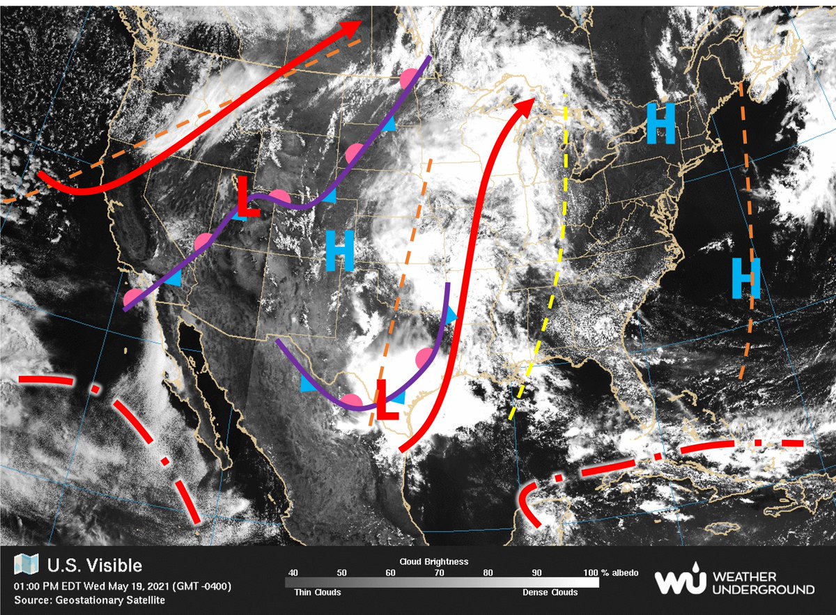
Currently, the weather is pretty stable over southern CA with persistent June gloom hovering above. What looks more interesting is the convective system in coastal TX and LA. It seems that the divergence associated with the westerly jet is favoring convection.
@uciess@UCIrvine
This system is already onshore so it will not into a tropical cyclone. However, according to WPC, the coast TX and LA will still receive 50-100mm (2-4 inches) of rain, potentially leading to flash floods. Be extra careful if you are currently staying there.
The drizzling in Irvine is just a thin layer of nimbostratus. Imagine the sunny weather up there...
[source: https://t.co/WFzQS4spg5, https://t.co/RcCx44kpYx]
Hello Anteaters! Here is the UCI American Meteorological Society (AMS) Student Chapter: zotCAMS weather forecast. If you would like to learn more about how we made this forecast please visit our website or join zotCAMS at @UCIRVINE@UCIESS (https://t.co/gu7VWxZ26C).
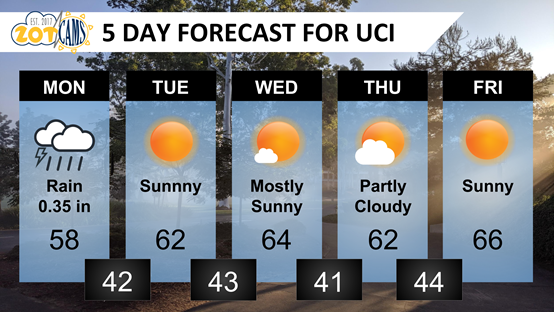
Looks like we have some surprise showers this Monday Morning, but the rest of the week looks good. There is a slight chance of showers on Wednesday, but we can expect clear and average temperatures for this time of year for the rest of the week.
Hello Anteaters! Here is the UCI American Meteorological Society (AMS) Student Chapter: zotCAMS weather forecast. If you would like to learn more about how we made this forecast please visit our website or join zotCAMS at @UCIRVINE@UCIESS (https://t.co/gu7VWxZ26C).
This is going to be a wild week. The persistent high over the southwest has shifted over the Pacific allowing numerous low pressure systems to reach southern California. We can expect cool temperatures, snow in the mountains, and possibly record precipitation Wednesday-Friday.
Here is the UCI American Meteorological Society (AMS) Student Chapter: zotCAMS weather forecast. If you would like to learn more about how we made this forecast please visit our website or join zotCAMS at @UCIRVINE@UCIESS (https://t.co/gu7VWxZ26C).
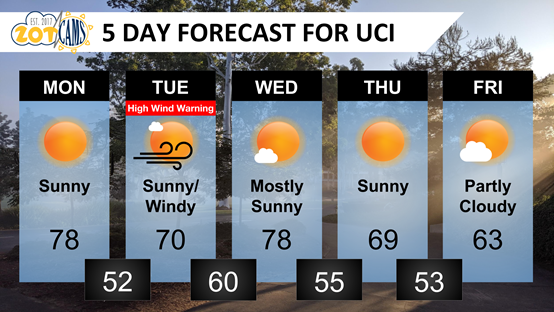
Looks like we might have some interesting weather this week. A strong Santa Ana Wind event is forecast to begin Tuesday with wind gusts possibly as high as 75 mph. We may also get some rain next weekend. You know, water that falls from the sky sometimes here in SoCal.
Very strong offshore winds will occur late this evening through early Wednesday morning. The best chance for a large fire will be late this evening through Tuesday morning when humidity will be at its lowest. However, a large fire will be possible anytime through Wednesday.
Wildland Fire: RPT @ 1:16 a.m. 28000blk Bonita Vista Rd. In Mountain Center. The fire is currently 15 acres, burning in heavy vegetation and pine trees. Fact sheet posted on our website: https://t.co/pSmyt9bOvl under the BONITA Incident. #BonitaFIRE
Hello Anteaters! Here is the UCI American Meteorological Society (AMS) Student Chapter: zotCAMS weather forecast. If you would like to learn more about how we made this forecast please visit our website or join zotCAMS at @UCIRVINE@UCIESS (https://t.co/gu7VWxZ26C).
Looks like Irvine will be impacted by the second major storm of the season after the first that occurred in early November. We can expect rain and possibly a thunderstorm or two in the region on Monday.
This year is abnormally dry which is no surprise as we are in the La Nina ENSO phase, which generally means a dryer than normal winter for Southern California.
Video from W rim of the caldera just before midnight. As of December 21 at 1:30 a.m. HST, the growing lava lake has almost reached the level of the lowest down-dropped block that formed during the 2018 collapse events. Over the past 2 hours, the lake has risen by ~10 m (32 ft).
Hello Anteaters! Here is the UCI American Meteorological Society (AMS) Student Chapter: zotCAMS weather forecast. If you would like to learn more about how we made this forecast please visit our website or join zotCAMS at @UCIRVINE@UCIESS (https://t.co/gu7VWxZ26C).
Looks like much of the same this week with abundant sunshine and winter temperatures (for Southern California that is). Next week is looking interesting with a change in the jet stream and the possibility of some rain. Stay tuned.
Here is the UCI American Meteorological Society (AMS) Student Chapter. If you would like to learn more about how we made this forecast please visit our website or join zotCAMS at @UCIRVINE@UCIESS (https://t.co/gu7VWxZ26C).
Hello Anteaters! Looks like we will have another Santa Ana wind event and Red Flag Warning for increased fire danger Monday and Tuesday. Tuesday will see increased temperatures and dry conditions, which will disappear Wednesday as a cooling trend hits UCI.