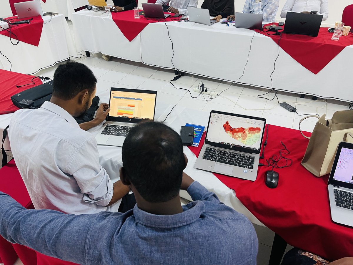
From data to decision: faster, smarter & still human-verified. #SWALIM’s AI Masterclass in Nairobi explored how AI can strengthen Somalia’s climate, water & land information systems: automating QA, detecting anomalies, improving metadata & turning data into actionable E-Warning.
#Mapping Somalia's urban future!
With @cooperazione_it support, #FAOSWALIM trained @imc_puntland & line ministries on urban sprawl assessment & land cover mapping — building skills for smarter, evidence-based planning and land management.
Moderate rains improving conditions in the north, but severe drought persists in south & central. Rising Shabelle River levels pose localized flood risks particularly along breakage points while heat & uneven rainfall continue to stress livelihoods.
👉🏽 https://t.co/wEmP92chjc
Proud to see the publication of the Land Cover Reference System for Somalia, developed by #SWALIM with @FAOLandWater. A milestone for standardized land cover classification and a key step toward stronger environmental intelligence & planning in Somalia.
https://t.co/o0RGWifZLl
#FAOSWALIM has concluded a training on Impact-Based Flood Forecasting & Anticipatory Action targeting SODMA, MoEWR, MoECC, MOLFR, SNBS & FMS States, to strengthen flood risk analysis, define triggers, apply models, and inform early action to protect vulnerable communities.
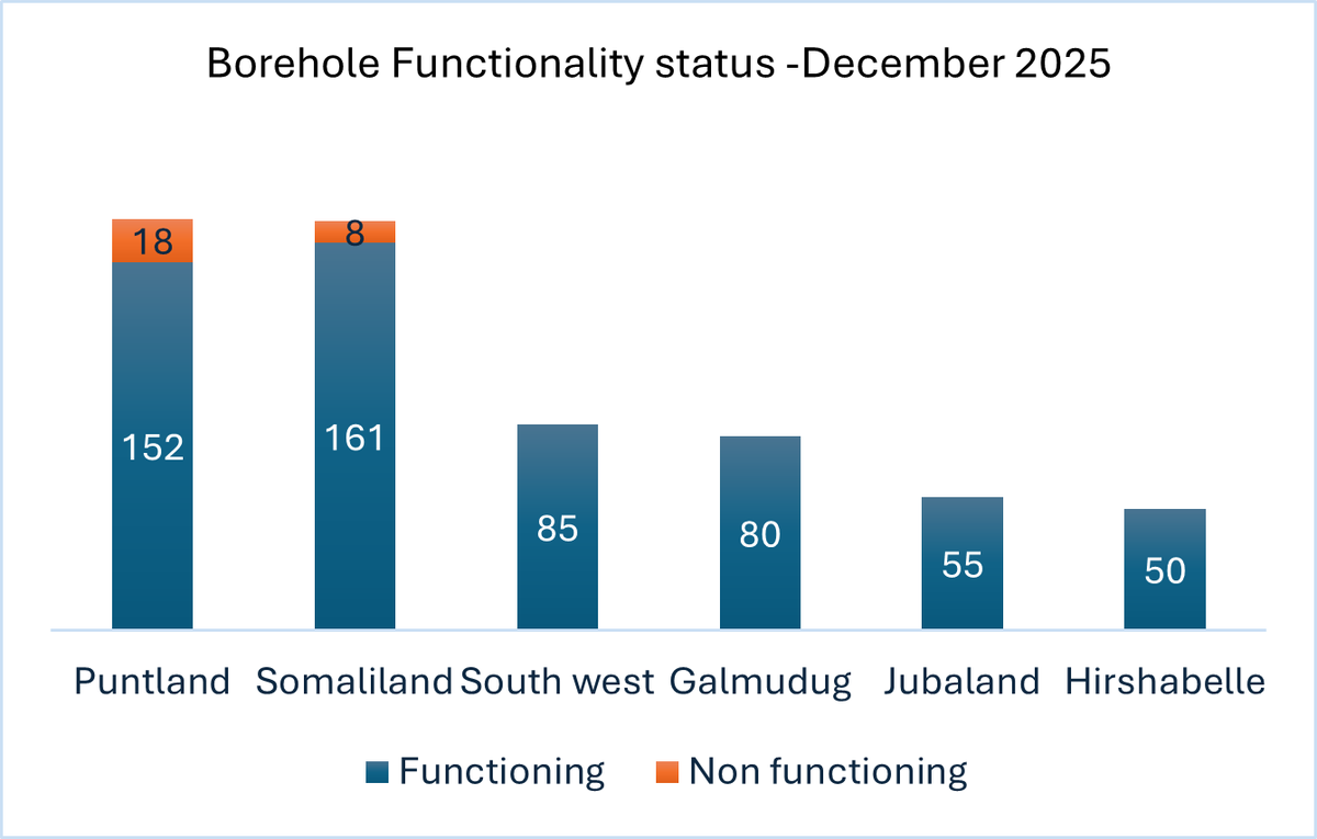
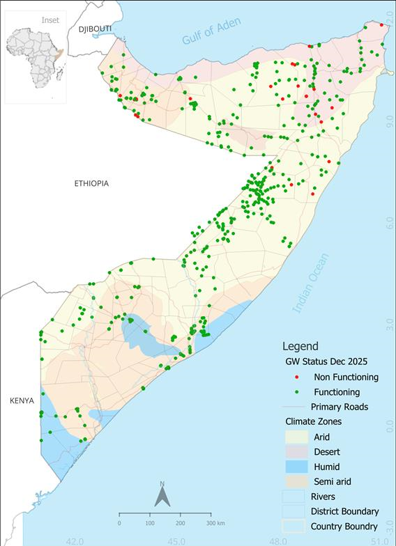
Groundwater update: Drought is exacerbating dependence on groundwater for HHs & livestock in #Somalia. Poor Deyr rains + high demand are straining aquifers North & parts of the South, signalling a tough Jilaal. Monitoring & timely repairs are critical.
🔗:https://t.co/QXDyBzLt8p
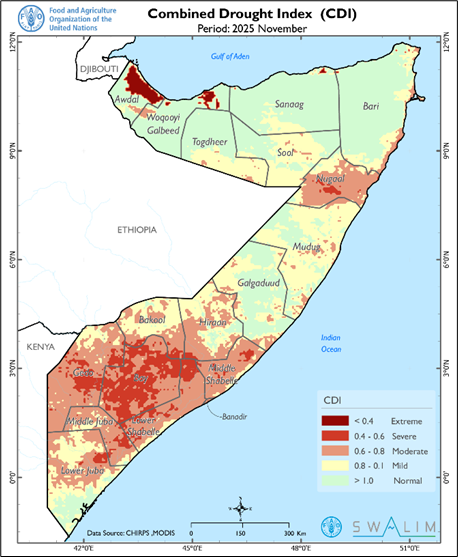
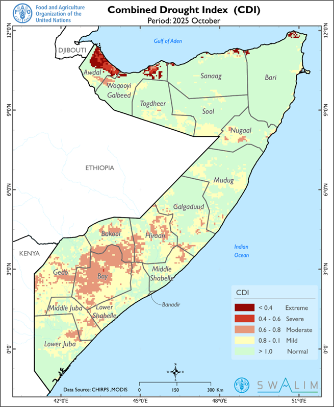
#Somalia is facing a worsening #drought: failed Deyr rains, water shortages, livestock losses & rising displacement. #SWALIM & #FSNAU warn that without urgent, coordinated action now, millions risk severe food insecurity as the Jilaal dry season begins.
👉🏽https://t.co/Vq7oKhjakd
Weather Alert:
➡️Dry conditions across🇸🇴only isolated light showers in south
➡️Southern regions face heat stress(35–40°C)
➡️Drought worsening, water shortages crop failure & livestock deaths
➡️Juba & Shabelle river levels continue to fall low flood risk
🔗:https://t.co/eDohKm19Jw
➡️Dry week ahead for Somalia, especially Somaliland & Puntland
➡️Only isolated light rains expected in the south & central coast
➡️Hot days in the south→heat stress & high evapotranspiration
➡️Juba & Shabelle rivers dropping→flood risk remains very low
https://t.co/mHbbcBFu3S
#FAOSWALIM conducted training for @imc_puntland and line ministry staff on land degradation monitoring and sand-dune mapping using Google Earth Engine and QGIS. The enhanced skills will support improved tracking of degraded areas and guide evidence-based restoration efforts.
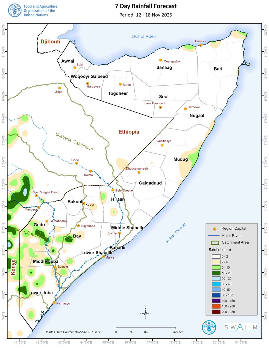
➡️Dry, hot week ahead for most of Somalia with light rains only in the south
➡️Heat to worsen water & pasture stress
➡️Deyr rains below normal, drought worsening
➡️Juba and Shabelle Rivers falling with low flood risk
#FAOSWALIM
👉🏾https://t.co/3j6JJB5ci9
➡️ Light rains expected in isolated areas in the south; most northern and central regions remain dry
➡️ Low flood risk along Juba and Shabelle Rivers
➡️ Persistent heat likely to increase evapotranspiration and thermal stress in the south
#FAOSWALIM
👉🏾 https://t.co/4qwgFAd3bd
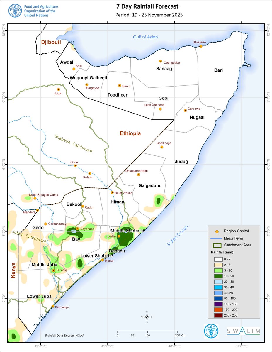
➡️ Light to moderate rains possible in the south, northern and central regions remain dry
➡️ Juba and Shabelle rivers remain below flood thresholds
➡️ Extremely high temperatures (above 40 °C) in the south
Today at #EACON2025 in Mogadishu I highlighted how #FAOSWALIM’s 20+ years of climate, land & water data underpin #AI for food security & agriculture.
Quality data is key to move from crisis response to predictive, resilient & inclusive food systems. 🌱
#AI4Ag#Somalia#FAO
FAO-SWALIM wrapped up a 3-week training in Hargeisa on land cover #mapping, data collection & machine learning. 12 staff from the SL IMC & line ministries (MoEWR, MoECC, MoAI, MoPIED, MOLFR & NADFOR) gained skills to map invasive species like Prosopis & Cactus.
Thanks to @SwissEmbassyKE, @FAOSWALIM trained relevant government staff in Somaliland on drought monitoring using the Combined Drought Index.
With evolving drought risk, the training aimed to strengthen early warning systems and improve drought preparedness.
🚨River Breakages Update:
⚠️ 207 open breakage points identified – 98 on the Shabelle River & 109 on the Juba River, requiring immediate action.
⚠️ 181 overflow points, 3 canal breakage points, & 76 canal flooding points posing serious risks.
More➡️: https://t.co/Mbc3bk4AVT
.@FAOSWALIM successfully completed fieldwork in Baki, Borama, and Gabiley, mapping invasive species such as Prosopis & Cactus, and evaluating NRM sites for conservation and land restoration.
A special thanks to @SwissEmbassyKE for their invaluable support in the #SIRAII project.